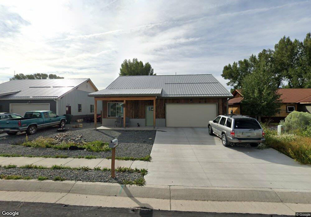
707 Andrew Ln Gunnison, CO 81230
Estimated Value: $722,332 - $778,000
3
Beds
2
Baths
1,298
Sq Ft
$571/Sq Ft
Est. Value
About This Home
This home is located at 707 Andrew Ln, Gunnison, CO 81230 and is currently estimated at $741,333, approximately $571 per square foot. 707 Andrew Ln is a home located in Gunnison County with nearby schools including Gunnison Elementary School, Gunnison Middle School, and Crested Butte Community School.
Ownership History
Date
Name
Owned For
Owner Type
Purchase Details
Closed on
May 24, 2023
Sold by
Kowal Eric and Kowal Emily
Bought by
Manning Patrick and Manning Kate
Current Estimated Value
Home Financials for this Owner
Home Financials are based on the most recent Mortgage that was taken out on this home.
Original Mortgage
$521,100
Outstanding Balance
$506,291
Interest Rate
6.27%
Mortgage Type
New Conventional
Estimated Equity
$235,042
Purchase Details
Closed on
Dec 10, 2014
Sold by
Daniel Mckenna and Bombard Ronald
Bought by
Kowal Eric and Kowal Emily
Create a Home Valuation Report for This Property
The Home Valuation Report is an in-depth analysis detailing your home's value as well as a comparison with similar homes in the area
Home Values in the Area
Average Home Value in this Area
Purchase History
| Date | Buyer | Sale Price | Title Company |
|---|---|---|---|
| Manning Patrick | $579,000 | None Listed On Document | |
| Kowal Eric | $37,000 | None Available |
Source: Public Records
Mortgage History
| Date | Status | Borrower | Loan Amount |
|---|---|---|---|
| Open | Manning Patrick | $521,100 |
Source: Public Records
Tax History Compared to Growth
Tax History
| Year | Tax Paid | Tax Assessment Tax Assessment Total Assessment is a certain percentage of the fair market value that is determined by local assessors to be the total taxable value of land and additions on the property. | Land | Improvement |
|---|---|---|---|---|
| 2024 | $2,190 | $45,860 | $9,670 | $36,190 |
| 2023 | $2,190 | $15,030 | $7,760 | $7,270 |
| 2022 | $1,202 | $20,300 | $20,300 | $0 |
| 2021 | $1,052 | $20,300 | $20,300 | $0 |
| 2020 | $910 | $16,560 | $16,560 | $0 |
| 2019 | $889 | $16,560 | $16,560 | $0 |
| 2018 | $592 | $10,730 | $10,730 | $0 |
| 2017 | $599 | $10,730 | $10,730 | $0 |
| 2016 | $565 | $10,150 | $10,150 | $0 |
Source: Public Records
Map
Nearby Homes
- 700 U S 50
- 706 Andrew Ln
- Lots 13-16 Us Highway 50 Frontage Rd
- 314 S 5th St
- TBD S 6th St
- 301 S 2nd St Unit 68
- 300 Bevington Rd
- 302 S 5th St
- 1412 W Gunnison Ave
- 215 S 7th St
- 288 S 5th St
- 1511 W Tomichi Ave
- 107 Wildrose Ln
- 137 Park Dr
- 133 Park Dr
- 1208 W Tomichi Ave Unit 4
- 1709 W Tomichi Ave
- 109 N 7th St
- 417 S Boulevard St Unit B
- 1314 W Tomichi Ave Unit 9
- 709 Andrew Ln
- 705 Andrew Ln
- 711 Andrew Ln
- 802 W Us Highway 50
- 703 Andrew Ln
- 703 Andrew Ln Unit (West Side by Old Dr
- 713 Andrew Ln
- 700 W Us Highway 50
- 700 W Hwy 50 Unit Lot 5
- 700 W Hwy 50 Unit Lot 7
- 700 W Us Highway 50 Unit Lot 6
- 700 W Us Highway 50
- 708 Andrew Ln
- 701 Andrew Ln
- 715 Andrew Ln
- 808 W Us Highway 50
- 712 Andrew Ln
- 704 & 706 Andrew Ln
- 704 Andrew Ln
- 701 Andrew Ln