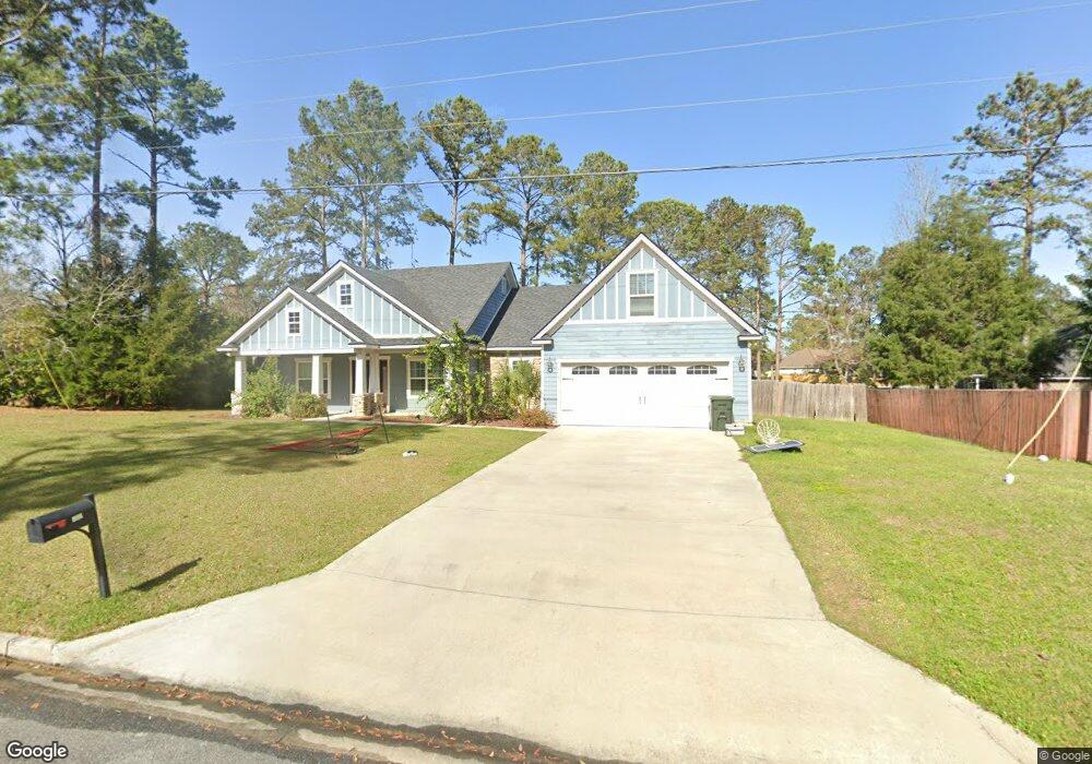
707 Fry Rd Hahira, GA 31632
Estimated Value: $322,000 - $363,813
4
Beds
3
Baths
2,067
Sq Ft
$167/Sq Ft
Est. Value
About This Home
This home is located at 707 Fry Rd, Hahira, GA 31632 and is currently estimated at $344,953, approximately $166 per square foot. 707 Fry Rd is a home located in Lowndes County with nearby schools including Hahira Elementary School, Hahira Middle School, and Lowndes High School.
Ownership History
Date
Name
Owned For
Owner Type
Purchase Details
Closed on
Apr 4, 2016
Sold by
Katelyn A Spring
Bought by
Brown John
Current Estimated Value
Home Financials for this Owner
Home Financials are based on the most recent Mortgage that was taken out on this home.
Original Mortgage
$183,889
Outstanding Balance
$146,232
Interest Rate
3.71%
Estimated Equity
$198,721
Purchase Details
Closed on
Oct 31, 2014
Sold by
Foxborough Development Cor
Bought by
Brown John Randal and Brown Jessica Renee
Purchase Details
Closed on
Mar 30, 2004
Bought by
Foxborough Development Corporation
Create a Home Valuation Report for This Property
The Home Valuation Report is an in-depth analysis detailing your home's value as well as a comparison with similar homes in the area
Home Values in the Area
Average Home Value in this Area
Purchase History
| Date | Buyer | Sale Price | Title Company |
|---|---|---|---|
| Brown John | -- | -- | |
| Brown John Randal | $15,000 | -- | |
| Foxborough Development Corporation | -- | -- |
Source: Public Records
Mortgage History
| Date | Status | Borrower | Loan Amount |
|---|---|---|---|
| Open | Brown John | $183,889 | |
| Closed | Brown John | -- |
Source: Public Records
Tax History Compared to Growth
Tax History
| Year | Tax Paid | Tax Assessment Tax Assessment Total Assessment is a certain percentage of the fair market value that is determined by local assessors to be the total taxable value of land and additions on the property. | Land | Improvement |
|---|---|---|---|---|
| 2024 | $3,651 | $139,451 | $16,000 | $123,451 |
| 2023 | $3,543 | $131,461 | $16,000 | $115,461 |
| 2022 | $3,513 | $117,732 | $16,000 | $101,732 |
| 2021 | $2,520 | $85,428 | $9,600 | $75,828 |
| 2020 | $2,554 | $85,428 | $9,600 | $75,828 |
| 2019 | $2,576 | $85,428 | $9,600 | $75,828 |
| 2018 | $2,704 | $83,568 | $9,600 | $73,968 |
| 2017 | $2,742 | $83,568 | $9,600 | $73,968 |
| 2016 | $316 | $9,600 | $9,600 | $0 |
| 2015 | $190 | $9,600 | $9,600 | $0 |
| 2014 | $155 | $4,800 | $4,800 | $0 |
Source: Public Records
Map
Nearby Homes
- 605 S Nelson St
- The Walker Plan at Reynolda Place
- The Belfort Plan at Reynolda Place
- The Ozark Plan at Reynolda Place
- The Beau Plan at Reynolda Place
- 627 Stagecoach Trail
- 1063 Angie Ln
- 1055 Angie Ln
- 1105 Hannah Dr
- 3001 Houser Way
- 1109 Hannah Dr
- 489 Bryson Cir
- 497 Bryson Cir
- 1130 Hannah Dr
- 1131 Hannah Dr
- 1135 Hannah Dr
- 601 Katherine Ln
- 1138 Hannah Dr
- 1139 Hannah Dr
- 411 Judy Ann Dr
- 523 Cottonwood Cove
- 527 Cottonwood Cove
- 400 E Coleman Dr
- 0 Hahira Unit 7139036
- 0 Hahira Unit 20084204
- 404 E Coleman Dr
- 302 E Coleman Dr
- 701 S Nelson St
- 531 Cottonwood Cove
- 406 E Coleman Dr
- 737 Fry Rd
- 611 Weaver St
- 500 E Coleman Dr
- 303 E Coleman Dr
- 612 S College St
- 535 Cottonwood Cove
- 535 Cottonwood Cove
- 739 Fry Rd
- 739 Fry Rd
- 803 S Nelson St