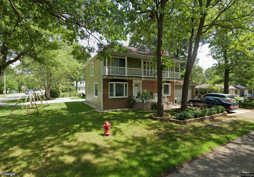
7071 Richardson Rd West Bloomfield, MI 48323
Estimated Value: $339,292 - $375,000
3
Beds
3
Baths
1,918
Sq Ft
$187/Sq Ft
Est. Value
About This Home
This home is located at 7071 Richardson Rd, West Bloomfield, MI 48323 and is currently estimated at $358,073, approximately $186 per square foot. 7071 Richardson Rd is a home located in Oakland County with nearby schools including Walled Lake Central High School, Our Lady Of Refuge School, and Frankel Jewish Academy Of Metro Detroit.
Ownership History
Date
Name
Owned For
Owner Type
Purchase Details
Closed on
Nov 26, 2008
Sold by
Federal National Mortgage Association
Bought by
Russell Nigel
Current Estimated Value
Purchase Details
Closed on
Sep 28, 2007
Sold by
Mortgage Electronic Registration Systems
Bought by
Federal National Mortgage Association
Purchase Details
Closed on
Sep 4, 2007
Sold by
Marvin Kevin R and Marvin Lori S
Bought by
Mortgage Electronic Registration Systems
Purchase Details
Closed on
Feb 12, 2001
Sold by
Nordeen Kathy J
Bought by
Marvin Kevin R
Home Financials for this Owner
Home Financials are based on the most recent Mortgage that was taken out on this home.
Original Mortgage
$117,000
Interest Rate
7.13%
Create a Home Valuation Report for This Property
The Home Valuation Report is an in-depth analysis detailing your home's value as well as a comparison with similar homes in the area
Home Values in the Area
Average Home Value in this Area
Purchase History
| Date | Buyer | Sale Price | Title Company |
|---|---|---|---|
| Russell Nigel | $120,000 | Warranty Title Agency Llc | |
| Federal National Mortgage Association | -- | None Available | |
| Mortgage Electronic Registration Systems | $159,900 | None Available | |
| Marvin Kevin R | $167,000 | -- |
Source: Public Records
Mortgage History
| Date | Status | Borrower | Loan Amount |
|---|---|---|---|
| Previous Owner | Marvin Kevin R | $117,000 |
Source: Public Records
Tax History Compared to Growth
Tax History
| Year | Tax Paid | Tax Assessment Tax Assessment Total Assessment is a certain percentage of the fair market value that is determined by local assessors to be the total taxable value of land and additions on the property. | Land | Improvement |
|---|---|---|---|---|
| 2024 | $1,724 | $149,360 | $0 | $0 |
| 2022 | $1,626 | $126,590 | $19,310 | $107,280 |
| 2021 | $2,674 | $121,360 | $0 | $0 |
| 2020 | $1,607 | $118,680 | $19,310 | $99,370 |
| 2018 | $2,603 | $106,850 | $16,080 | $90,770 |
| 2015 | -- | $86,250 | $0 | $0 |
| 2014 | -- | $78,530 | $0 | $0 |
| 2011 | -- | $65,640 | $0 | $0 |
Source: Public Records
Map
Nearby Homes
- 4245 Bunker Ave
- 4335 Crestdale Ave
- 6978 Colony Dr
- 4212 Greendale Ave
- 7337 Richardson Rd
- 7381 Crestmore St
- 4442 Borland St
- 3991 Fieldview Ave
- 6903 Dandison Blvd
- 4066 Green Lake Rd
- 6980 Hambro St
- 3965 Carrick Ave
- 0000 Langtoft
- 6675 Langtoft St
- 3950 Bradmore Ave
- 4540 Rolling Pine Ct
- 3631 Elder Rd S
- 3876 Elder Rd S
- 6630 Heron Point
- 3673 Highview St
- 7065 Richardson Rd
- 7059 Richardson Rd
- 4265 Middledale Ave
- 4260 Cedar Ave
- 4242 Middledale Ave
- 4250 Middledale Ave
- 7086 Richardson Rd
- 0 Cedar Ave Unit 217014061
- 4270 Cedar Ave
- 4272 Middledale Ave Unit Bldg-Unit
- 4272 Middledale Ave
- 4231 Crestdale Ave
- 4291 Middledale Ave
- 4174 Cedar Ave
- 4290 Cedar Ave
- 4251 Crestdale Ave
- 7121 Richardson Rd
- 4271 Cedar Ave
- 4163 Middledale Ave
- 4166 Middledale Ave