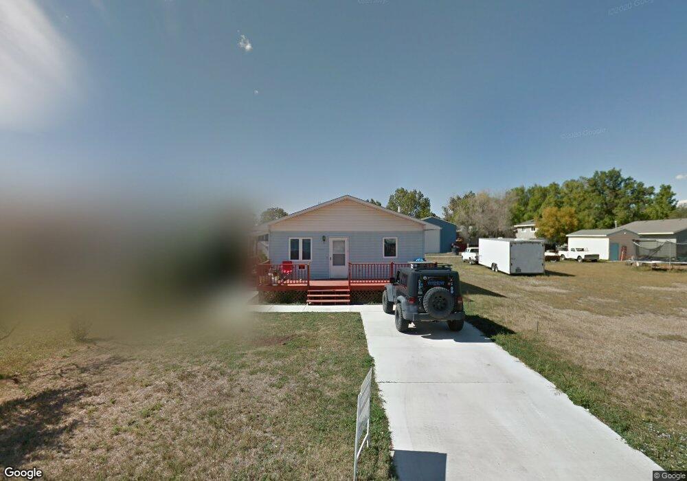
708 Mullberry Ave Laurel, MT 59044
Estimated Value: $217,000 - $275,000
3
Beds
2
Baths
1,040
Sq Ft
$246/Sq Ft
Est. Value
About This Home
This home is located at 708 Mullberry Ave, Laurel, MT 59044 and is currently estimated at $256,008, approximately $246 per square foot. 708 Mullberry Ave is a home located in Yellowstone County with nearby schools including Fred W. Graff School, West School, and Laurel Middle School.
Ownership History
Date
Name
Owned For
Owner Type
Purchase Details
Closed on
Dec 31, 2015
Sold by
Baskin James
Bought by
Johnston Robert C
Current Estimated Value
Purchase Details
Closed on
Jan 6, 2014
Sold by
Johnson Sheri L
Bought by
Baskin James
Home Financials for this Owner
Home Financials are based on the most recent Mortgage that was taken out on this home.
Original Mortgage
$129,000
Interest Rate
4.17%
Mortgage Type
VA
Create a Home Valuation Report for This Property
The Home Valuation Report is an in-depth analysis detailing your home's value as well as a comparison with similar homes in the area
Home Values in the Area
Average Home Value in this Area
Purchase History
| Date | Buyer | Sale Price | Title Company |
|---|---|---|---|
| Johnston Robert C | -- | American Title & Escrow | |
| Baskin James | -- | None Available |
Source: Public Records
Mortgage History
| Date | Status | Borrower | Loan Amount |
|---|---|---|---|
| Previous Owner | Baskin James | $129,000 |
Source: Public Records
Tax History
| Year | Tax Paid | Tax Assessment Tax Assessment Total Assessment is a certain percentage of the fair market value that is determined by local assessors to be the total taxable value of land and additions on the property. | Land | Improvement |
|---|---|---|---|---|
| 2025 | $1,899 | $237,000 | $56,449 | $180,551 |
| 2024 | $1,899 | $190,300 | $36,672 | $153,628 |
| 2023 | $1,753 | $190,300 | $36,672 | $153,628 |
| 2022 | $1,293 | $154,900 | $0 | $0 |
| 2021 | $1,530 | $154,900 | $0 | $0 |
| 2020 | $1,515 | $151,000 | $0 | $0 |
| 2019 | $1,508 | $151,000 | $0 | $0 |
| 2018 | $1,502 | $144,800 | $0 | $0 |
| 2017 | $1,393 | $144,800 | $0 | $0 |
| 2016 | $1,297 | $135,800 | $0 | $0 |
| 2015 | $140 | $135,800 | $0 | $0 |
| 2014 | $1,229 | $68,316 | $0 | $0 |
Source: Public Records
Map
Nearby Homes
- 1108 E 8th St
- 1104 E 8th St
- 605 Date Ave
- 1031 Fir Ave
- 1321 E Railroad St
- 801 E 4th St
- 717 E 5th, 506 Alder Ave
- 717 E 5th St
- 601 E 5th St
- 414 Wyoming Ave
- 809 Pennsylvania Ave
- 516 Pennsylvania Ave
- 110 E 5th St
- 1665 Wild Lupine Ln
- 603 5th Ave
- 1319 Valley Dr
- 116 4th Ave
- 1627 Brookway Cir
- 409 Maple Ave
- 319 6th Ave
- 708 Mullberry Ave
- 708 Mulberry Ave
- 702 Mullberry Ave
- 711 Locust Ave
- 715 Locust Ave
- 707 Locust Ave
- 1612 E 8th St
- 703 Locust Ave
- 719 Locust Ave
- 1702 E 8th St
- 0 Yard Office & Eleanor Roosevelt
- 723 Locust Ave
- 1619 E Main St
- 617 Locust Ave
- 619 Locust Ave
- 1603 E 8th St
- 710 Locust Ave
- 714 Locust Ave
- 706 Locust Ave
- 702 Locust Ave
Your Personal Tour Guide
Ask me questions while you tour the home.