Estimated Value: $429,000 - $511,000
3
Beds
2
Baths
2,079
Sq Ft
$228/Sq Ft
Est. Value
About This Home
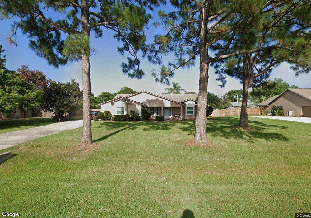
This home is located at 7085 Hundred Acre Dr, Cocoa, FL 32927 and is currently estimated at $474,414, approximately $228 per square foot. 7085 Hundred Acre Dr is a home located in Brevard County with nearby schools including Enterprise Elementary School, Space Coast Junior/Senior High School, and Sculptor Charter School.
Ownership History
Date
Name
Owned For
Owner Type
Purchase Details
Closed on
Apr 1, 2025
Sold by
Viscardi Carol A
Bought by
Viscardi Carol A and Viscardi Corinne E
Current Estimated Value
Purchase Details
Closed on
Dec 20, 1993
Sold by
Romar Homes Inc
Bought by
Viscardi Richard J and Viscardi Carol A
Home Financials for this Owner
Home Financials are based on the most recent Mortgage that was taken out on this home.
Original Mortgage
$50,000
Interest Rate
7.05%
Create a Home Valuation Report for This Property
The Home Valuation Report is an in-depth analysis detailing your home's value as well as a comparison with similar homes in the area
Home Values in the Area
Average Home Value in this Area
Purchase History
| Date | Buyer | Sale Price | Title Company |
|---|---|---|---|
| Viscardi Carol A | $100 | None Listed On Document | |
| Viscardi Richard J | -- | -- | |
| Viscardi Richard J | $143,600 | -- |
Source: Public Records
Mortgage History
| Date | Status | Borrower | Loan Amount |
|---|---|---|---|
| Previous Owner | Viscardi Richard J | $50,000 |
Source: Public Records
Tax History
| Year | Tax Paid | Tax Assessment Tax Assessment Total Assessment is a certain percentage of the fair market value that is determined by local assessors to be the total taxable value of land and additions on the property. | Land | Improvement |
|---|---|---|---|---|
| 2025 | $2,245 | $177,390 | -- | -- |
| 2024 | $2,198 | $172,400 | -- | -- |
| 2023 | $2,198 | $167,380 | -- | -- |
| 2022 | $2,166 | $162,510 | $0 | $0 |
| 2021 | $2,198 | $157,780 | $0 | $0 |
| 2020 | $2,131 | $155,610 | $0 | $0 |
| 2019 | $2,074 | $152,120 | $0 | $0 |
| 2018 | $2,075 | $149,290 | $0 | $0 |
| 2017 | $2,086 | $146,220 | $0 | $0 |
| 2016 | $2,124 | $143,220 | $32,000 | $111,220 |
| 2015 | $2,174 | $142,230 | $32,000 | $110,230 |
| 2014 | $2,184 | $141,110 | $32,000 | $109,110 |
Source: Public Records
Map
Nearby Homes
- 7065 Hundred Acre Dr
- 6990 Bryant Rd
- 5555 Brandon St
- 6815 Bryant Rd
- 7230 Venus Ave
- 5165 Patricia St
- 7200 Oakwood Ave
- 5155 Mayflower St
- 6760 Cairo Rd
- 6615 Dock Ave
- 7635 Fringe Place
- 5075 Carter St
- 5080 Mayflower St
- 6581 Bancroft Ave
- TBD Freeport Rd
- 5200 Frisco St
- 7545 Fringe Place
- 5150 Melody St
- 5740 Friendly St
- 7419 Hackberry Rd
- 7075 Hundred Acre Dr
- 6960 Kaylor Ave
- 6950 Kaylor Ave
- 7105 Hundred Acre Dr
- 6970 Kaylor Ave
- 7080 Hundred Acre Dr
- 6940 Kaylor Ave
- 7090 Hundred Acre Dr
- 7070 Hundred Acre Dr
- 6980 Kaylor Ave
- 7100 Hundred Acre Dr
- 6930 Kaylor Ave
- 7045 Hundred Acre Dr
- 7115 Hundred Acre Dr
- 7060 Hundred Acre Dr
- 6985 Pluto Ave
- 7005 Pluto Ave
- 7110 Hundred Acre Dr
- 6920 Kaylor Ave
- 7015 Pluto Ave
Your Personal Tour Guide
Ask me questions while you tour the home.