NOT LISTED FOR SALE

7091 Upper Burningtown Rd Franklin, NC 28734

Estimated Value: $171,405

3 Beds
1 Bath
-- Sq Ft
1.73 Acres

Last Sold December 22, 2014

Last sale price $44,000

Est. 290% increase in value since last sale

Current estimated payment $937/month

263 Days on Market

Highlights

  • 1.73 Acre Lot
  • Private Lot
  • No HOA
  • Wood Burning Stove
  • Wood Flooring
  • Cottage

About This Home

As of December 2014

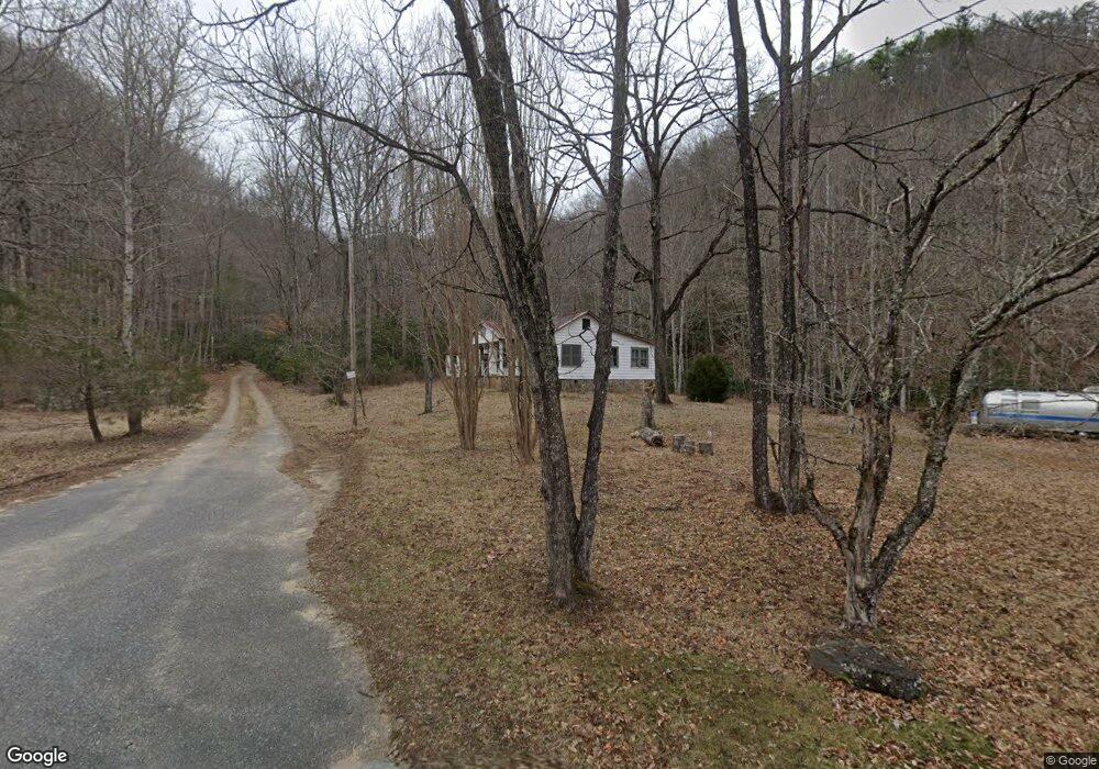
Older home built in 1950 being sold AS IS. Most of the value is in this incredible property and the Burningtown Creek( 15 feet wide) frontage it has. Property is very gentle and would be great for a RV or motorhome because of the easy state paved road access. Property is on both sides of the road. This parcel has lots of mountain laurel along the great creek frontage. A very loud small waterfall is located on this property. A lot of water sounds on this parcel. Old home has hardwood floors but owner knows nothing about how they got drinking water or where the septic is. Appalachian Trail close

Last Agent to Sell the Property

Jamie Stamey

Unique Properties Of Franklin Brokerage Phone: 8283494700 License #160001 Listed on: 03/02/2014

Home Details

Home Type

  • Single Family

Est. Annual Taxes

  • $244

Year Built

  • Built in 1950

Lot Details

  • 1.73 Acre Lot
  • Property fronts a state road
  • Private Lot
  • Level Lot
  • Historic Home

Parking

  • No Garage

Home Design

  • Cottage
  • Vinyl Siding

Interior Spaces

  • Fireplace
  • Wood Burning Stove
  • Wood Flooring
  • Crawl Space
  • No Kitchen Appliances
  • Property Views

Bedrooms and Bathrooms

  • 3 Bedrooms
  • 1 Full Bathroom

Outdoor Features

  • Outdoor Storage

Utilities

  • Cooling Available
  • Heating Available
  • No Water Heater

Community Details

  • No Home Owners Association
  • Stream

Listing and Financial Details

  • Assessor Parcel Number 6546730819

Home Details

Home Type

Single Family

Est. Annual Taxes

$244

Year Built

Built in 1950

Lot Details

0

Listing Details

  • Property Sub Type: Residential
  • Prop. Type: Residential
  • Lot Size Acres: 1.73
  • Road Frontage Type: State Road
  • Road Surface Type: Paved
  • Ownership: More than One Year
  • Subdivision Name: No
  • Directions: 28 North appx 3 miles to L on Airport Rd. Go past Airport & bear L on Olive Hill Rd which then turns into Upper Burningtown Rd farther down. When you turn L on Airport Rd it is 7.09 miles to this parcel at the end of the state paved road. LO signs on both sides of the road.
  • Architectural Style: Cottage
  • Carport Y N: No
  • Garage Yn: No
  • Structure Type: Historical
  • Year Built: 1950
  • NAV27_rets_property_type: Residential
  • Attribution Contact: 8283494700
  • Special Features: None

Interior Features

  • Furnished: Unfurnished
  • Appliances: No Water Heater, None
  • Has Basement: Crawl Space
  • Full Bathrooms: 1
  • Total Bedrooms: 3
  • Door Features: Other Doors (See Remarks)
  • Fireplace Features: Wood Burning Stove
  • Fireplace: Yes
  • Flooring: Hardwood
  • Interior Amenities: Other
  • Window Features: Other Windows (See Remarks)
  • Living Room Living Room Level: First
  • Room Living Room Area: 144
  • Room Kitchen Area: 100

Exterior Features

  • Lot Features: Private, Unrestricted, Level, Level Yard
  • View: View Year Round, Short Range View
  • View: Yes
  • Home Warranty: No
  • Construction Type: Vinyl Siding
  • Other Structures: Storage Building/Shed
  • Roof: Other

Garage/Parking

  • Attached Garage: No
  • Parking Features: No Garage, None-Carport

Utilities

  • Cooling: Other
  • Cooling Y N: Yes
  • Heating: Other
  • Heating Yn: Yes
  • Sewer: TWSA, Other
  • Water Source: Other

Condo/Co-op/Association

  • Senior Community: No
  • Association: No

Lot Info

  • Lot Size Sq Ft: 75358.8
  • Parcel #: 6546730819
  • ResoLotSizeUnits: Acres

Multi Family

  • Above Grade Finished Area Units: Square Feet

Tax Info

  • Tax Annual Amount: 243.67
  • Tax Book Number: O-31

Ownership History

Date Name Owned For Owner Type

Purchase Details

Closed on
Aug 1, 2007
Sold by
Mason Marvin Conrad and Browning Christy Mae Mason
Bought by
Harben Keith E and Harben Marsha P
Current Estimated Value
$171,405
Source: Public Records

Range of Values:

Collateral Analytics

Collateral Analytics Collateral Analytics AVMs (Automated Valuation Model) employ a number of statistical approaches combined with neighborhood-specific comparable selection guarantees the most up-to-date and precise valuations.

Not Available

Collateral Analytics does not have data for the current month. Please view the chart for historical values.

ICE

ICE Mortgage Technology ICE Mortgage Technology’s AVM (Automated Valuation Model) is a state-of-the-art online residential property valuation tool that provides a quick and accurate estimate of the value of almost any home in the U.S.

Not Available

ICE Mortgage Technology does not have data for the current month. Please view the chart for historical values.

First American

First American First American Data & Analytics’ next-generation AVM combines unrivaled data assets with a blended ensemble of valuation models to produce highly accurate, reliable valuations you can trust.

Not Available

First American does not have data for the current month. Please view the chart for historical values.

Quantarium

Quantarium Quantarium’s valuation service, repeatedly proven the industry’s most accurate and comprehensive, is supercharged with a self-learning and auto-tuning AI engine that continually becomes smarter and more accurate as it processes daily inputs from the industry’s leading RE data lake.

Not Available

Quantarium does not have data for the current month. Please view the chart for historical values.

Average Value
Not Available
List Price
Sold Price
Create a Home Valuation Report for This Property
The Home Valuation Report is an in-depth analysis detailing your home's value as well as a comparison with similar homes in the area

Home Values in the Area

Source: Public Records

Average Home Value in this Area


Source: Public Records

Purchase History

Date Buyer Sale Price Title Company
Harben Keith E $57,000 None Available
Source: Public Records

Property History

Date Event Price List to Sale Price per Sq Ft
12/22/2014 12/22/14 Sold $44,000 0.0% --
11/22/2014 11/22/14 Pending -- -- --
03/03/2014 03/03/14 For Sale $44,000 -- --
Source: Carolina Smokies Association of REALTORS®

Tax History Compared to Growth

Source: Public Records

Tax History

Year Tax Paid Tax Assessment Tax Assessment Total Assessment is a certain percentage of the fair market value that is determined by local assessors to be the total taxable value of land and additions on the property. Land Improvement
2025 $305 $53,200 $36,470 $16,730
2024 -- $53,200 $36,470 $16,730
2023 $294 $53,200 $36,470 $16,730
2022 $294 $36,020 $22,980 $13,040
2021 $290 $36,020 $22,980 $13,040
2020 $281 $36,020 $22,980 $13,040
2018 $287 $42,620 $25,530 $17,090
2017 $287 $42,620 $25,530 $17,090
2016 $281 $42,620 $25,530 $17,090
2015 $258 $42,620 $25,530 $17,090
2014 $244 $49,330 $32,180 $17,150
2013 -- $49,330 $32,180 $17,150
Source: Public Records

Agents Affiliated with this Home

  • Section Image
See All Agents

Map

Source: Carolina Smokies Association of REALTORS®

MLS Number: 53617

APN: 6546730819