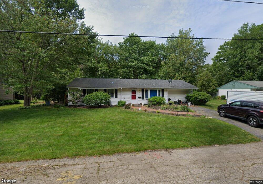
71 Appleby St Brockton, MA 02302
Campello NeighborhoodEstimated Value: $479,000 - $483,585
3
Beds
1
Bath
1,204
Sq Ft
$399/Sq Ft
Est. Value
About This Home
This home is located at 71 Appleby St, Brockton, MA 02302 and is currently estimated at $480,896, approximately $399 per square foot. 71 Appleby St is a home located in Plymouth County with nearby schools including Davis K-8 School, John F. Kennedy Elementary School, and South Middle School.
Ownership History
Date
Name
Owned For
Owner Type
Purchase Details
Closed on
Feb 26, 1988
Sold by
Smith Evelyn M
Bought by
Nunn Patricia A
Current Estimated Value
Create a Home Valuation Report for This Property
The Home Valuation Report is an in-depth analysis detailing your home's value as well as a comparison with similar homes in the area
Home Values in the Area
Average Home Value in this Area
Purchase History
| Date | Buyer | Sale Price | Title Company |
|---|---|---|---|
| Nunn Patricia A | $127,800 | -- |
Source: Public Records
Mortgage History
| Date | Status | Borrower | Loan Amount |
|---|---|---|---|
| Open | Nunn Patricia A | $36,870 | |
| Open | Nunn Patricia A | $191,250 |
Source: Public Records
Tax History Compared to Growth
Tax History
| Year | Tax Paid | Tax Assessment Tax Assessment Total Assessment is a certain percentage of the fair market value that is determined by local assessors to be the total taxable value of land and additions on the property. | Land | Improvement |
|---|---|---|---|---|
| 2025 | $4,966 | $410,100 | $160,400 | $249,700 |
| 2024 | $4,750 | $395,200 | $160,400 | $234,800 |
| 2023 | $4,585 | $353,200 | $110,700 | $242,500 |
| 2022 | $4,220 | $302,100 | $100,600 | $201,500 |
| 2021 | $4,237 | $292,200 | $93,500 | $198,700 |
| 2020 | $3,957 | $261,200 | $82,000 | $179,200 |
| 2019 | $3,602 | $231,800 | $78,300 | $153,500 |
| 2018 | $3,381 | $210,500 | $78,300 | $132,200 |
| 2017 | $2,838 | $176,300 | $78,300 | $98,000 |
| 2016 | $3,062 | $176,400 | $74,600 | $101,800 |
| 2015 | $2,730 | $150,400 | $74,600 | $75,800 |
| 2014 | $2,834 | $156,300 | $74,600 | $81,700 |
Source: Public Records
Map
Nearby Homes
- 139 Geralynn Dr
- 122 Sinclair Rd
- 578 Plain St
- 768 East St
- 24 Ithica Rd
- 16 Friendship Dr
- 1 Thomas Cir
- 15 Longworth Ave Unit 231
- 221 Sinclair Rd
- 229 Sinclair Rd
- 35 Longworth Ave Unit 17
- 18 American Ave
- 597 East St
- 163 S Leyden St
- 1435 Main St
- 12 Paulin Ave
- 44 Baker St
- 13 Finny's Way
- 1 Fairway Dr
- 358 Copeland St