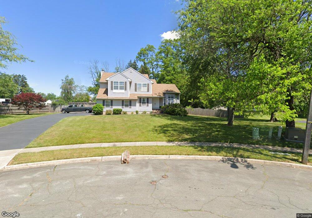
71 Brophy Ct Ewing, NJ 08638
Ewingville NeighborhoodEstimated Value: $557,000 - $681,000
Studio
--
Bath
2,418
Sq Ft
$249/Sq Ft
Est. Value
About This Home
This home is located at 71 Brophy Ct, Ewing, NJ 08638 and is currently estimated at $601,994, approximately $248 per square foot. 71 Brophy Ct is a home located in Mercer County with nearby schools including Ewing High School, Trenton Stem-To-Civics Charter School, and Guidepost Montessori at Lawrenceville.
Ownership History
Date
Name
Owned For
Owner Type
Purchase Details
Closed on
Jul 11, 2000
Sold by
Lostaunau Michael
Bought by
Marinelli Donald and Marinelli Karen
Current Estimated Value
Home Financials for this Owner
Home Financials are based on the most recent Mortgage that was taken out on this home.
Original Mortgage
$200,000
Outstanding Balance
$72,935
Interest Rate
8.5%
Estimated Equity
$529,059
Purchase Details
Closed on
Aug 29, 1997
Sold by
Tuffy Thomas
Bought by
Lostanau Michael and Brostrom Erika
Home Financials for this Owner
Home Financials are based on the most recent Mortgage that was taken out on this home.
Original Mortgage
$207,000
Interest Rate
7.46%
Purchase Details
Closed on
Jul 21, 1992
Sold by
Aspen Knolls Construction South Inc
Bought by
Tuffy Thomas and Tuffy Jennifer
Create a Home Valuation Report for This Property
The Home Valuation Report is an in-depth analysis detailing your home's value as well as a comparison with similar homes in the area
Home Values in the Area
Average Home Value in this Area
Purchase History
| Date | Buyer | Sale Price | Title Company |
|---|---|---|---|
| Marinelli Donald | $274,900 | -- | |
| Lostanau Michael | $230,000 | -- | |
| Tuffy Thomas | $231,000 | -- |
Source: Public Records
Mortgage History
| Date | Status | Borrower | Loan Amount |
|---|---|---|---|
| Open | Marinelli Donald | $200,000 | |
| Previous Owner | Lostanau Michael | $207,000 |
Source: Public Records
Tax History
| Year | Tax Paid | Tax Assessment Tax Assessment Total Assessment is a certain percentage of the fair market value that is determined by local assessors to be the total taxable value of land and additions on the property. | Land | Improvement |
|---|---|---|---|---|
| 2025 | $12,715 | $323,300 | $90,200 | $233,100 |
| 2024 | $11,952 | $323,300 | $90,200 | $233,100 |
Source: Public Records
Map
Nearby Homes
- 2 Sparrow Ct
- 19 van Saun Dr
- 2148 Pennington Rd
- 632 Timberlake Dr
- 311 Timberlake Dr
- 20 Corey Dr
- 34 Lopatcong Dr
- 222 Masterson Ct
- 231 Masterson Ct
- 235 Masterson Ct
- 89 Upper Ferry Rd
- 146 Masterson Ct
- 10 Howe Ct
- 611 Masterson Ct
- 13 Hickory Hill Dr
- 7 Diverty Rd
- 200 Amberleigh Dr Unit 32H
- 6 Van Gogh Ct
- 305 Tuxford Ct
- 305 Deer Run Ct Unit C
Your Personal Tour Guide
Ask me questions while you tour the home.