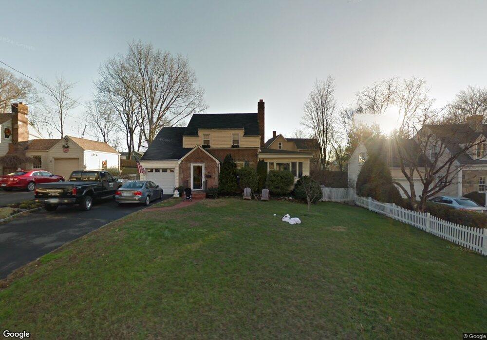
71 Glendale Dr Stamford, CT 06906
Glenbrook NeighborhoodEstimated Value: $780,000 - $864,000
4
Beds
2
Baths
1,864
Sq Ft
$439/Sq Ft
Est. Value
About This Home
This home is located at 71 Glendale Dr, Stamford, CT 06906 and is currently estimated at $819,083, approximately $439 per square foot. 71 Glendale Dr is a home located in Fairfield County with nearby schools including Julia A. Stark Elementary School, Dolan School, and Stamford High School.
Ownership History
Date
Name
Owned For
Owner Type
Purchase Details
Closed on
Sep 26, 2007
Sold by
Magness Mark A and Magness Mary Ed
Bought by
Wilson Lindsay C
Current Estimated Value
Purchase Details
Closed on
Jul 1, 2002
Sold by
Lines Andrew
Bought by
Magness Alex
Home Financials for this Owner
Home Financials are based on the most recent Mortgage that was taken out on this home.
Original Mortgage
$300,700
Interest Rate
6.92%
Mortgage Type
Purchase Money Mortgage
Purchase Details
Closed on
Jul 16, 1999
Sold by
Galante Timothy J and Galante Theresa
Bought by
Lines Andrew
Purchase Details
Closed on
Feb 12, 1993
Sold by
Paris Peter
Bought by
Galante Timothy and Galante Theresa
Create a Home Valuation Report for This Property
The Home Valuation Report is an in-depth analysis detailing your home's value as well as a comparison with similar homes in the area
Home Values in the Area
Average Home Value in this Area
Purchase History
| Date | Buyer | Sale Price | Title Company |
|---|---|---|---|
| Wilson Lindsay C | $661,000 | -- | |
| Wilson Lindsay C | $661,000 | -- | |
| Magness Alex | $429,610 | -- | |
| Magness Alex | $429,610 | -- | |
| Lines Andrew | $343,500 | -- | |
| Lines Andrew | $343,500 | -- | |
| Galante Timothy | $205,000 | -- | |
| Galante Timothy | $205,000 | -- |
Source: Public Records
Mortgage History
| Date | Status | Borrower | Loan Amount |
|---|---|---|---|
| Previous Owner | Galante Timothy | $386,000 | |
| Previous Owner | Galante Timothy | $300,700 |
Source: Public Records
Tax History Compared to Growth
Tax History
| Year | Tax Paid | Tax Assessment Tax Assessment Total Assessment is a certain percentage of the fair market value that is determined by local assessors to be the total taxable value of land and additions on the property. | Land | Improvement |
|---|---|---|---|---|
| 2025 | $9,827 | $415,330 | $222,010 | $193,320 |
| 2024 | $9,611 | $415,330 | $222,010 | $193,320 |
| 2023 | $10,325 | $415,330 | $222,010 | $193,320 |
| 2022 | $8,904 | $333,000 | $170,460 | $162,540 |
| 2021 | $8,808 | $333,000 | $170,460 | $162,540 |
| 2020 | $8,581 | $333,000 | $170,460 | $162,540 |
| 2019 | $8,581 | $333,000 | $170,460 | $162,540 |
| 2018 | $8,265 | $333,000 | $170,460 | $162,540 |
| 2017 | $7,703 | $296,260 | $143,190 | $153,070 |
| 2016 | $7,486 | $296,260 | $143,190 | $153,070 |
| 2015 | $7,291 | $296,260 | $143,190 | $153,070 |
| 2014 | $7,048 | $296,260 | $143,190 | $153,070 |
Source: Public Records
Map
Nearby Homes
- 51 Glendale Rd
- 596 Glenbrook Rd Unit 36
- 31 Bellmere Ave
- 88 Pine Hill Ave
- 34 Crescent St Unit 2D
- 406 Courtland Ave Unit D
- 43 Crescent St Unit 11
- 59 Holbrook Dr
- 30 Maple Tree Ave Unit D
- 30 Lake Dr
- 543 Newfield Ave
- 143 Overbrook Dr
- 35 Maple Tree Ave Unit 6
- 8 Windell Place
- 62 Maple Tree Ave Unit 62
- 27 Crane Rd N
- 88 Maple Tree Ave Unit G
- 30 Lindsey Ave
- 69 Maple Tree Ave Unit 4
- 31 Sussex Place