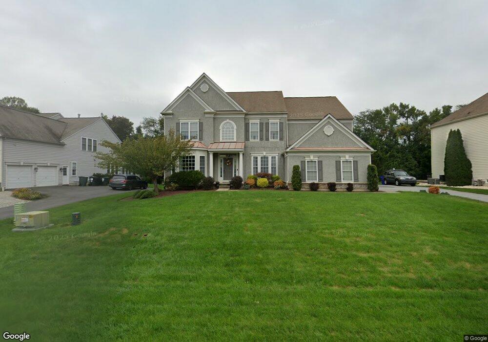
71 Hempstead Dr Newark, DE 19702
Estimated Value: $656,275 - $774,000
4
Beds
4
Baths
3,610
Sq Ft
$194/Sq Ft
Est. Value
About This Home
This home is located at 71 Hempstead Dr, Newark, DE 19702 and is currently estimated at $700,569, approximately $194 per square foot. 71 Hempstead Dr is a home located in New Castle County with nearby schools including Olive B. Loss Elementary School, Alfred G. Waters Middle School, and Appoquinimink High School.
Ownership History
Date
Name
Owned For
Owner Type
Purchase Details
Closed on
Jan 30, 2007
Sold by
Pulte Home Corp
Bought by
Frushon Joseph and Frushon Deborah L
Current Estimated Value
Home Financials for this Owner
Home Financials are based on the most recent Mortgage that was taken out on this home.
Original Mortgage
$320,000
Outstanding Balance
$189,726
Interest Rate
6.16%
Mortgage Type
Purchase Money Mortgage
Estimated Equity
$510,843
Purchase Details
Closed on
Jan 20, 2005
Sold by
395 Associates Llc
Bought by
Pulte Home Corp
Create a Home Valuation Report for This Property
The Home Valuation Report is an in-depth analysis detailing your home's value as well as a comparison with similar homes in the area
Home Values in the Area
Average Home Value in this Area
Purchase History
| Date | Buyer | Sale Price | Title Company |
|---|---|---|---|
| Frushon Joseph | $521,950 | None Available | |
| Pulte Home Corp | $7,755,000 | -- |
Source: Public Records
Mortgage History
| Date | Status | Borrower | Loan Amount |
|---|---|---|---|
| Open | Frushon Joseph | $320,000 |
Source: Public Records
Tax History
| Year | Tax Paid | Tax Assessment Tax Assessment Total Assessment is a certain percentage of the fair market value that is determined by local assessors to be the total taxable value of land and additions on the property. | Land | Improvement |
|---|---|---|---|---|
| 2024 | $5,224 | $120,700 | $15,200 | $105,500 |
| 2023 | $4,480 | $120,700 | $15,200 | $105,500 |
| 2022 | $4,492 | $120,700 | $15,200 | $105,500 |
| 2021 | $4,388 | $120,700 | $15,200 | $105,500 |
| 2020 | $4,388 | $120,700 | $15,200 | $105,500 |
| 2019 | $450 | $120,700 | $15,200 | $105,500 |
| 2018 | $3,943 | $120,700 | $15,200 | $105,500 |
| 2017 | $3,784 | $120,700 | $15,200 | $105,500 |
| 2016 | $3,444 | $120,700 | $15,200 | $105,500 |
| 2015 | -- | $120,700 | $15,200 | $105,500 |
| 2014 | -- | $120,700 | $15,200 | $105,500 |
Source: Public Records
Map
Nearby Homes
- 95 Hempstead Dr
- 45 Hempstead Dr
- 9 Hempstead Dr
- 242 Torrey Dr
- 178 Torrey Dr
- 116 Torrey Dr
- 2956 Frazer Rd
- 3017 Frenchtown Rd
- 38 Stardust Dr
- 61 Rose Hill Dr
- 9 Coralberry Dr
- 7 Keeneland Ct
- 14 Inkberry Ct
- 34 Photinia Dr
- 52 Eaton Place
- 18 Devalinder Dr
- 2664 Glasgow Ave
- 121 Devalinder Dr
- 15 Eaton Place
- 5 Lyon Ct
- 73 Hempstead Dr
- 69 Hempstead Dr
- 1000 Hempstead Dr
- 1100 Hempstead Dr
- 1200 Hempstead Dr
- 1300 Hempstead Dr
- 75 Hempstead Dr
- 67 Hempstead Dr
- 133 Haut Brion Ave
- 135 Haut Brion Ave
- 131 Haut Brion Ave
- 70 Hempstead Dr
- 137 Haut Brion Ave
- 72 Hempstead Dr
- 129 Haut Brion Ave
- 77 Hempstead Dr
- 65 Hempstead Dr
- 68 Hempstead Dr
- 74 Hempstead Dr
- 139 Haut Brion Ave
Your Personal Tour Guide
Ask me questions while you tour the home.