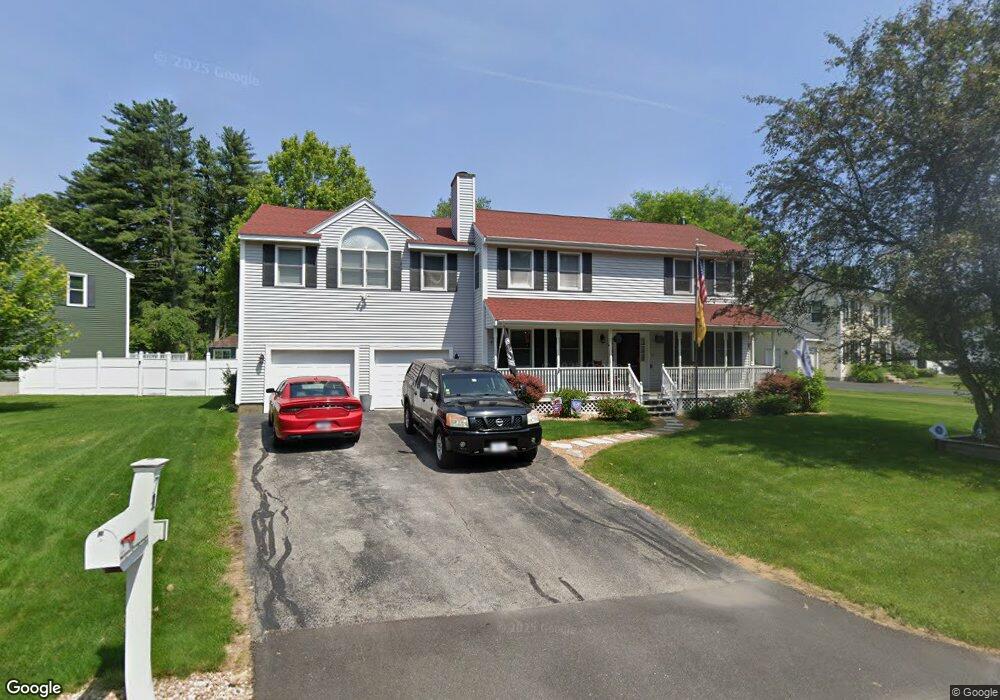
71 Mallard Point Rd Merrimack, NH 03054
Estimated Value: $716,000 - $780,000
4
Beds
3
Baths
2,904
Sq Ft
$255/Sq Ft
Est. Value
About This Home
This home is located at 71 Mallard Point Rd, Merrimack, NH 03054 and is currently estimated at $739,358, approximately $254 per square foot. 71 Mallard Point Rd is a home located in Hillsborough County with nearby schools including Reeds Ferry School, James Mastricola Upper Elementary School, and Merrimack Middle School.
Ownership History
Date
Name
Owned For
Owner Type
Purchase Details
Closed on
Jul 22, 2015
Sold by
Mills Steven L and Mills Linda J
Bought by
Couch Jerry C
Current Estimated Value
Home Financials for this Owner
Home Financials are based on the most recent Mortgage that was taken out on this home.
Original Mortgage
$361,446
Outstanding Balance
$283,304
Interest Rate
4.01%
Mortgage Type
VA
Estimated Equity
$456,054
Purchase Details
Closed on
Nov 22, 2010
Sold by
Aubut Andrew S and Aubut Kristin
Bought by
Mills Steven L and Mills Linda J
Home Financials for this Owner
Home Financials are based on the most recent Mortgage that was taken out on this home.
Original Mortgage
$256,000
Interest Rate
4.3%
Mortgage Type
Purchase Money Mortgage
Purchase Details
Closed on
Dec 31, 2001
Sold by
Obrien Sue Ellen and Obrien Kevin
Bought by
Aubut Andrew S and Aubut Kristin
Home Financials for this Owner
Home Financials are based on the most recent Mortgage that was taken out on this home.
Original Mortgage
$189,600
Interest Rate
6.61%
Create a Home Valuation Report for This Property
The Home Valuation Report is an in-depth analysis detailing your home's value as well as a comparison with similar homes in the area
Home Values in the Area
Average Home Value in this Area
Purchase History
| Date | Buyer | Sale Price | Title Company |
|---|---|---|---|
| Couch Jerry C | $349,933 | -- | |
| Mills Steven L | $320,000 | -- | |
| Aubut Andrew S | $237,000 | -- |
Source: Public Records
Mortgage History
| Date | Status | Borrower | Loan Amount |
|---|---|---|---|
| Open | Aubut Andrew S | $361,446 | |
| Previous Owner | Aubut Andrew S | $256,000 | |
| Previous Owner | Aubut Andrew S | $78,000 | |
| Previous Owner | Aubut Andrew S | $189,600 |
Source: Public Records
Tax History Compared to Growth
Tax History
| Year | Tax Paid | Tax Assessment Tax Assessment Total Assessment is a certain percentage of the fair market value that is determined by local assessors to be the total taxable value of land and additions on the property. | Land | Improvement |
|---|---|---|---|---|
| 2024 | $10,966 | $530,000 | $174,900 | $355,100 |
| 2023 | $10,309 | $530,000 | $174,900 | $355,100 |
| 2022 | $9,211 | $530,000 | $174,900 | $355,100 |
| 2021 | $9,100 | $530,000 | $174,900 | $355,100 |
| 2020 | $8,462 | $351,700 | $130,800 | $220,900 |
| 2019 | $8,487 | $351,700 | $130,800 | $220,900 |
| 2018 | $8,483 | $351,700 | $130,800 | $220,900 |
| 2017 | $8,172 | $349,700 | $130,800 | $218,900 |
| 2016 | $7,970 | $349,700 | $130,800 | $218,900 |
| 2015 | $7,826 | $316,600 | $114,400 | $202,200 |
| 2014 | $7,627 | $316,600 | $114,400 | $202,200 |
| 2013 | $7,527 | $314,800 | $114,400 | $200,400 |
Source: Public Records
Map
Nearby Homes
- 12 Sandhill Dr
- 80 Wire Rd
- 87 Indian Rock Rd
- 79 Indian Rock Rd
- 20 Essex Green Ct
- 12 Clinton Ct
- 12 Davis Rd
- 2 Killian Ct
- 6 Stearns Ln Unit 202
- 12 Fernwood Dr
- 29 Bedford Rd
- 2 Bishop St
- 33 Belmont Dr
- 9 Edgewood Ave
- 42 Cota Rd
- 6 Boulder Way
- 21 Adams Green
- 16 Penacook Terrace
- 17 Echo Shore Dr
- 14 Echo Shore Dr