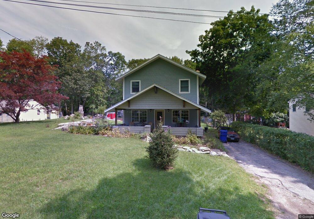
71 Mink Trail Coventry, CT 06238
Estimated Value: $321,000 - $439,000
3
Beds
2
Baths
1,600
Sq Ft
$236/Sq Ft
Est. Value
About This Home
This home is located at 71 Mink Trail, Coventry, CT 06238 and is currently estimated at $377,140, approximately $235 per square foot. 71 Mink Trail is a home located in Tolland County with nearby schools including George Hersey Robertson School, Coventry Grammar School, and Capt. Nathan Hale School.
Ownership History
Date
Name
Owned For
Owner Type
Purchase Details
Closed on
Jan 6, 2004
Sold by
Department Of Housing & Urban Dev
Bought by
Brazeal Suzanne
Current Estimated Value
Home Financials for this Owner
Home Financials are based on the most recent Mortgage that was taken out on this home.
Original Mortgage
$147,000
Interest Rate
5.86%
Purchase Details
Closed on
Feb 28, 1994
Sold by
Zannetos Diane
Bought by
Smith Jai
Create a Home Valuation Report for This Property
The Home Valuation Report is an in-depth analysis detailing your home's value as well as a comparison with similar homes in the area
Home Values in the Area
Average Home Value in this Area
Purchase History
| Date | Buyer | Sale Price | Title Company |
|---|---|---|---|
| Brazeal Suzanne | $85,000 | -- | |
| Smith Jai | $88,000 | -- | |
| Brazeal Suzanne | $85,000 | -- | |
| Smith Jai | $88,000 | -- |
Source: Public Records
Mortgage History
| Date | Status | Borrower | Loan Amount |
|---|---|---|---|
| Open | Smith Jai | $45,000 | |
| Closed | Smith Jai | $187,500 | |
| Closed | Smith Jai | $147,000 |
Source: Public Records
Tax History Compared to Growth
Tax History
| Year | Tax Paid | Tax Assessment Tax Assessment Total Assessment is a certain percentage of the fair market value that is determined by local assessors to be the total taxable value of land and additions on the property. | Land | Improvement |
|---|---|---|---|---|
| 2025 | $5,840 | $245,800 | $55,600 | $190,200 |
| 2024 | $4,364 | $131,000 | $46,100 | $84,900 |
| 2023 | $4,158 | $131,000 | $46,100 | $84,900 |
| 2022 | $4,081 | $131,000 | $46,100 | $84,900 |
| 2021 | $4,081 | $131,000 | $46,100 | $84,900 |
| 2020 | $4,083 | $131,000 | $46,100 | $84,900 |
| 2019 | $4,218 | $131,000 | $46,100 | $84,900 |
| 2018 | $4,186 | $130,000 | $46,100 | $83,900 |
| 2017 | $4,160 | $130,000 | $46,100 | $83,900 |
| 2016 | $4,056 | $130,000 | $46,100 | $83,900 |
| 2015 | $4,056 | $130,000 | $46,100 | $83,900 |
| 2014 | $4,219 | $148,200 | $55,700 | $92,500 |
Source: Public Records
Map
Nearby Homes
- 48 Lakeview Dr
- 83 Morin Ave
- 17 Ireland Dr
- 1902 South St
- 219 Reynolds Dr
- 131 Lakewood Dr
- 30 Knollwood Dr
- 152 Cheney Ln
- 35 Birch Trail
- 198 Forest Rd
- 39 Wood Trail
- 220 Buena Vista Rd
- 59 Woodland Rd
- 1365 Main St
- 122 High St
- 360 Sam Green Rd
- 94 Stonehouse Rd Unit 10
- 0 Skinner Hill Rd Unit 24077239
- 259 High St
- 40 Wheeling Rd
- 66 Wangumbaug Dr
- 77 Mink Trail
- 0 Wangumbaug Dr
- 68 Mink Trail
- 135 Fox Trail
- 92 Wangumbaug Dr
- 78 Mink Trail
- 86 Mink Trail
- 59 Beaver Trail
- 93 Wangumbaug Dr
- 46 Wangumbaug Dr
- 89 Mink Trail
- 138 Fox Trail
- 38 Mink Trail
- 72 Fox Trail
- 39 Mink Trail
- 39 Mink Trail
- 147 Fox Trail
- 117 Squirrel Trail
- 111 Squirrel Trail