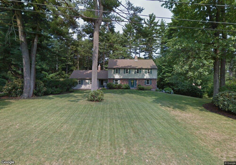
71 Pine Arden Dr West Boylston, MA 01583
Estimated Value: $660,000 - $1,210,000
4
Beds
3
Baths
2,401
Sq Ft
$340/Sq Ft
Est. Value
About This Home
This home is located at 71 Pine Arden Dr, West Boylston, MA 01583 and is currently estimated at $817,257, approximately $340 per square foot. 71 Pine Arden Dr is a home located in Worcester County with nearby schools including Major Edwards Elementary School and West Boylston Junior/Senior High School.
Ownership History
Date
Name
Owned For
Owner Type
Purchase Details
Closed on
Feb 11, 2021
Sold by
Johnston Brian E and Johnston Anne P
Bought by
B E Johnston Irt
Current Estimated Value
Purchase Details
Closed on
Aug 15, 1997
Sold by
Est Tully Nancy M and Mancuso Joseph C
Bought by
Johnston Brian E and Johnston Anne P
Create a Home Valuation Report for This Property
The Home Valuation Report is an in-depth analysis detailing your home's value as well as a comparison with similar homes in the area
Home Values in the Area
Average Home Value in this Area
Purchase History
| Date | Buyer | Sale Price | Title Company |
|---|---|---|---|
| B E Johnston Irt | -- | None Available | |
| Johnston Brian E | $250,000 | -- |
Source: Public Records
Mortgage History
| Date | Status | Borrower | Loan Amount |
|---|---|---|---|
| Previous Owner | Johnston Brian E | $245,000 | |
| Previous Owner | Johnston Brian E | $285,000 | |
| Previous Owner | Johnston Brian E | $209,900 | |
| Previous Owner | Johnston Brian E | $220,000 |
Source: Public Records
Tax History Compared to Growth
Tax History
| Year | Tax Paid | Tax Assessment Tax Assessment Total Assessment is a certain percentage of the fair market value that is determined by local assessors to be the total taxable value of land and additions on the property. | Land | Improvement |
|---|---|---|---|---|
| 2025 | $81 | $580,900 | $125,200 | $455,700 |
| 2024 | $7,758 | $524,900 | $128,700 | $396,200 |
| 2023 | $7,626 | $489,500 | $127,000 | $362,500 |
| 2022 | $7,388 | $417,900 | $130,500 | $287,400 |
| 2021 | $5,009 | $394,800 | $118,800 | $276,000 |
| 2020 | $4,711 | $372,300 | $121,900 | $250,400 |
| 2019 | $113 | $360,600 | $121,900 | $238,700 |
| 2018 | $3,691 | $346,600 | $121,900 | $224,700 |
| 2017 | $3,754 | $341,900 | $121,900 | $220,000 |
| 2016 | $6,293 | $341,100 | $113,400 | $227,700 |
| 2015 | $6,192 | $337,600 | $112,300 | $225,300 |
Source: Public Records
Map
Nearby Homes
- 113 Newton St
- 5 Marsh Hawk Way
- 16 N Main St
- 20 Winthrop St
- 12 Winthrop St
- 20 Holt St Unit G
- 64 Worcester St
- 101 Sterling St
- 156 Prospect St
- 39 Bowen St
- 112 N Main St
- 136 Sterling St Unit A3
- 225 Prescott St
- 152 Worcester St Unit 8
- 14 Maple St
- 363 Prospect St
- 216 River St
- 39 Davidson Rd
- 0 North St
- 687 Bullard St
- 65 Pine Arden Dr
- 77 Pine Arden Dr
- 74 Pine Arden Dr
- 66 Pine Arden Dr
- 57 Pine Arden Dr
- 46 Townsend Dr
- 29 Townsend Dr
- 72 Townsend Dr Unit 267
- 42 Townsend Dr
- 85 Pine Arden Dr
- 15 Townsend Dr
- 19 Townsend Dr
- 38 Townsend Dr
- 58 Townsend Dr
- 47 Pine Arden Dr
- 28 Pine Arden Dr
- 25 Townsend Dr
- 56 Townsend Dr
- 88 Pine Arden Dr
- 50 Townsend Dr