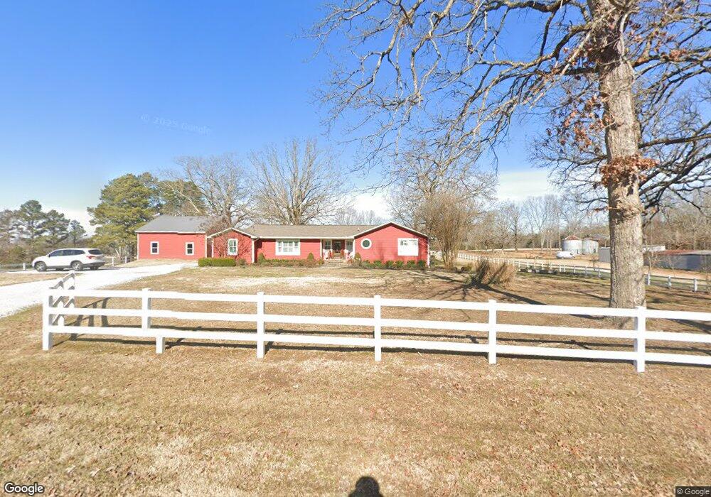
71 State Line Rd Michie, TN 38357
Estimated Value: $193,754 - $337,000
--
Bed
1
Bath
2,644
Sq Ft
$97/Sq Ft
Est. Value
About This Home
This home is located at 71 State Line Rd, Michie, TN 38357 and is currently estimated at $257,689, approximately $97 per square foot. 71 State Line Rd is a home located in McNairy County with nearby schools including Michie Elementary School, Ramer Elementary School, and Selmer Elementary School.
Ownership History
Date
Name
Owned For
Owner Type
Purchase Details
Closed on
Jan 11, 2017
Sold by
Allen Randall D
Bought by
Allen Andrew and Allen Sally
Current Estimated Value
Purchase Details
Closed on
Jan 5, 2004
Sold by
Etal Allen Karen D
Bought by
Allen Randall D
Purchase Details
Closed on
Feb 3, 2003
Sold by
Allen Karen D and Allen Randall D
Bought by
Walden Gilda J
Purchase Details
Closed on
Apr 10, 2002
Sold by
Allen Randall D
Bought by
Allen Karen D
Create a Home Valuation Report for This Property
The Home Valuation Report is an in-depth analysis detailing your home's value as well as a comparison with similar homes in the area
Home Values in the Area
Average Home Value in this Area
Purchase History
| Date | Buyer | Sale Price | Title Company |
|---|---|---|---|
| Allen Andrew | -- | -- | |
| Allen Randall D | $18,750 | -- | |
| Walden Gilda J | -- | -- | |
| Allen Karen D | $12,000 | -- |
Source: Public Records
Tax History Compared to Growth
Tax History
| Year | Tax Paid | Tax Assessment Tax Assessment Total Assessment is a certain percentage of the fair market value that is determined by local assessors to be the total taxable value of land and additions on the property. | Land | Improvement |
|---|---|---|---|---|
| 2025 | $673 | $42,700 | $0 | $0 |
| 2024 | $673 | $42,700 | $6,475 | $36,225 |
| 2023 | $673 | $42,700 | $6,475 | $36,225 |
| 2022 | $673 | $42,700 | $6,475 | $36,225 |
| 2021 | $724 | $35,400 | $6,625 | $28,775 |
| 2020 | $721 | $35,225 | $6,625 | $28,600 |
| 2019 | $721 | $35,225 | $6,625 | $28,600 |
| 2018 | $721 | $35,225 | $6,625 | $28,600 |
| 2017 | $721 | $35,225 | $6,625 | $28,600 |
| 2016 | $707 | $35,225 | $6,625 | $28,600 |
| 2015 | $736 | $35,225 | $6,625 | $28,600 |
| 2014 | $388 | $18,575 | $7,275 | $11,300 |
Source: Public Records
Map
Nearby Homes
- 106 Afton Dr
- 13 Quail Run Rd
- 820 John George Loop
- 14 Newcomb Dr
- 0 John George Loop Unit 10202475
- 0 John George Loop Unit 25-2649
- 1 Northtowne Dr
- 3 Northtowne Dr
- Lot 6 Northtown Dr
- Lot 12 Northtown Dr
- Lot 4 Northtown Dr
- Lot 5 Northtown Dr
- Lot 2 Northtown Dr
- Lot 11 Northtown Dr
- Lot 8 Northtown Dr
- Lot 16 Northtown Dr
- Lot 14 Northtown Dr
- Lot 7 Northtown Dr
- Lot 9 Northtown Dr
- Lot 15 Northtown Dr
- 72 State Line Rd
- 79 State Line Rd
- 5831 N Harper Road Extension
- 85 State Line Rd
- 5831 N County Road 138 Extension
- 87 State Line Rd
- 82 State Line Rd
- 5830 N Harper Road Extension
- 89 State Line Rd
- 5825 N Harper Road Extension
- 93 State Line Rd
- 97 State Line Rd
- 95 State Line Rd
- 5818 N Harper Road Extension
- 5817 N Harper Road Extension
- 51 State Line Rd
- 48 State Line Rd
- 103 State Line Rd
- 5800 N Harper Road Extension
- 5808 N Harper Road Extension