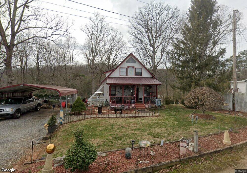
71 Swallow Ln Franklin, NC 28734
Estimated Value: $278,826 - $328,000
3
Beds
2
Baths
1,390
Sq Ft
$224/Sq Ft
Est. Value
About This Home
This home is located at 71 Swallow Ln, Franklin, NC 28734 and is currently estimated at $310,707, approximately $223 per square foot. 71 Swallow Ln is a home located in Macon County with nearby schools including Iotla Valley Elementary School, Mountain View Intermediate School, and Macon Middle School.
Ownership History
Date
Name
Owned For
Owner Type
Purchase Details
Closed on
Aug 9, 2006
Sold by
Haber Marvin S and Haber Mary Jeanette
Bought by
Voyles James B and Voyles Krist Ann
Current Estimated Value
Home Financials for this Owner
Home Financials are based on the most recent Mortgage that was taken out on this home.
Original Mortgage
$400,000
Outstanding Balance
$240,023
Interest Rate
6.75%
Mortgage Type
Adjustable Rate Mortgage/ARM
Estimated Equity
$70,684
Purchase Details
Closed on
Apr 20, 2006
Sold by
Evans Kelle E Lasky and Evans Joihn
Bought by
Sanders Susan
Home Financials for this Owner
Home Financials are based on the most recent Mortgage that was taken out on this home.
Original Mortgage
$104,000
Interest Rate
6.44%
Mortgage Type
New Conventional
Create a Home Valuation Report for This Property
The Home Valuation Report is an in-depth analysis detailing your home's value as well as a comparison with similar homes in the area
Home Values in the Area
Average Home Value in this Area
Purchase History
| Date | Buyer | Sale Price | Title Company |
|---|---|---|---|
| Voyles James B | $510,000 | None Available | |
| Sanders Susan | $130,000 | None Available | |
| Sanders Susan | $130,000 | None Available |
Source: Public Records
Mortgage History
| Date | Status | Borrower | Loan Amount |
|---|---|---|---|
| Open | Voyles James B | $400,000 | |
| Previous Owner | Sanders Susan | $104,000 |
Source: Public Records
Tax History
| Year | Tax Paid | Tax Assessment Tax Assessment Total Assessment is a certain percentage of the fair market value that is determined by local assessors to be the total taxable value of land and additions on the property. | Land | Improvement |
|---|---|---|---|---|
| 2025 | $816 | $204,230 | $26,340 | $177,890 |
| 2024 | $816 | $204,230 | $26,340 | $177,890 |
| 2023 | $672 | $204,130 | $26,340 | $177,790 |
| 2022 | $672 | $119,940 | $12,200 | $107,740 |
| 2021 | $653 | $119,940 | $12,200 | $107,740 |
| 2020 | $623 | $119,940 | $12,200 | $107,740 |
| 2018 | $454 | $88,940 | $15,490 | $73,450 |
| 2017 | $454 | $88,940 | $15,490 | $73,450 |
| 2016 | $445 | $88,940 | $15,490 | $73,450 |
| 2015 | $422 | $88,940 | $15,490 | $73,450 |
| 2014 | $430 | $115,980 | $20,910 | $95,070 |
| 2013 | -- | $115,980 | $20,910 | $95,070 |
Source: Public Records
Map
Nearby Homes
- 58 Swallow Ln
- Lot 26 Bryson City Rd
- Lot 19 Bryson City Rd
- 113 Courtney Marie Dr
- 00 Pine Ridge Dr
- 89 Nettie Hurst Rd
- 30 Maxies Corner Rd
- 381 Parsons Way
- 160 Lakeview Dr
- 153 Breezy Oak Ln
- 1616 Riverbend Rd
- Lot 44 Mews Ln
- 373 Trimont Trail
- 440 Lakeshore Dr
- Lot 46 Mews Ln
- Lot 32 Village Cir E
- 49 Village Cir E
- 1817 Lakeside Dr
- Lot S-16 Town Mountain Dr
- 00 Town Mountain Dr
- 0 Swallow Ln
- 53 Swallow Ln
- 84 Swallow Ln
- 91 Rolling Acres Trail
- 22 Swallow Ln
- 111 Rolling Acres Trail
- 112 Rolling Acres Trail
- 30 Rolling Acres Trail
- 125 Rolling Acres Trail
- 132 Rolling Acres Trail
- 108 Rolling Acres Trail
- 14 Rolling Acres Trail
- 1840 Bryson City Rd
- 85 K Ln
- 30 Maple Dr
- 30 Maple Dr
- 141 Rolling Acres Trail
- 60 Walnut Hill
- 81 K Ln
- 60 Walnut Hill Dr
Your Personal Tour Guide
Ask me questions while you tour the home.