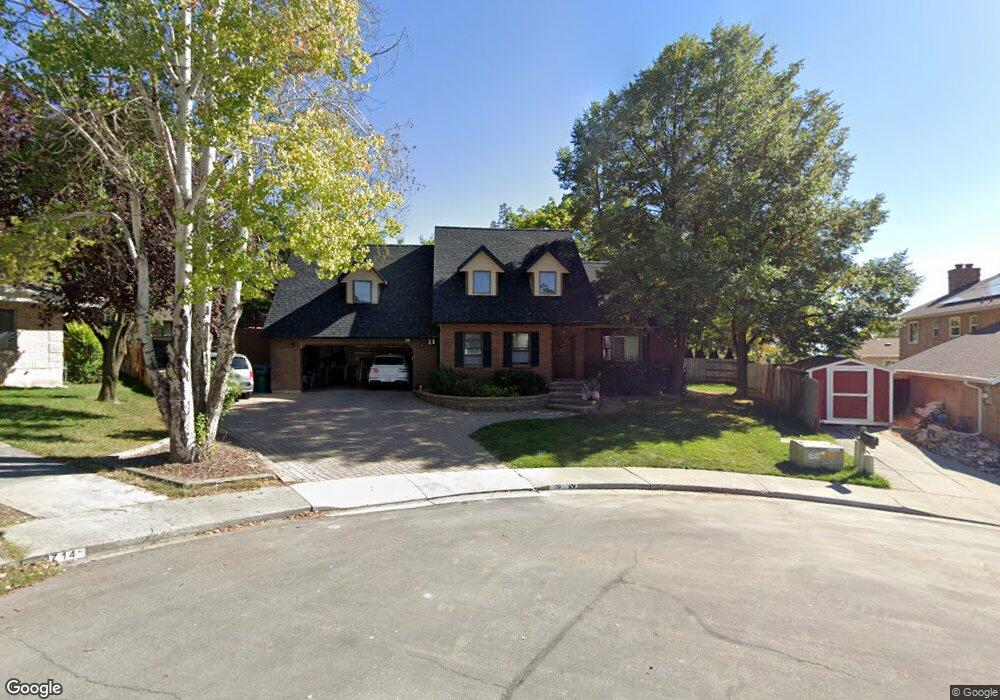
710 E 1950 N Orem, UT 84097
Northridge NeighborhoodEstimated Value: $646,292 - $799,000
3
Beds
2
Baths
2,106
Sq Ft
$332/Sq Ft
Est. Value
About This Home
This home is located at 710 E 1950 N, Orem, UT 84097 and is currently estimated at $698,431, approximately $331 per square foot. 710 E 1950 N is a home located in Utah County with nearby schools including Orchard Elementary School, Oak Canyon Junior High School, and Timpanogos High School.
Ownership History
Date
Name
Owned For
Owner Type
Purchase Details
Closed on
Dec 20, 2021
Sold by
Marital John and Marital Barbara
Bought by
Robertson John Steven
Current Estimated Value
Purchase Details
Closed on
Dec 1, 2020
Sold by
Steven Robertson John
Bought by
Robertson Family Legacy Trust
Purchase Details
Closed on
Sep 26, 2019
Sold by
Robertson John S and The John S Robertson Family Tr
Bought by
Robertson John S and Robertson Barbara C
Purchase Details
Closed on
Nov 7, 2016
Sold by
Roberson John S and Roberson Barbara C
Bought by
Robertson Barbara C and The Barbara S Robertson Family
Create a Home Valuation Report for This Property
The Home Valuation Report is an in-depth analysis detailing your home's value as well as a comparison with similar homes in the area
Home Values in the Area
Average Home Value in this Area
Purchase History
| Date | Buyer | Sale Price | Title Company |
|---|---|---|---|
| Robertson John Steven | -- | None Listed On Document | |
| Robertson Family Legacy Trust | -- | None Listed On Document | |
| Robertson John S | -- | None Available | |
| Robertson Barbara C | -- | None Available |
Source: Public Records
Tax History
| Year | Tax Paid | Tax Assessment Tax Assessment Total Assessment is a certain percentage of the fair market value that is determined by local assessors to be the total taxable value of land and additions on the property. | Land | Improvement |
|---|---|---|---|---|
| 2025 | $2,378 | $323,345 | -- | -- |
| 2024 | $2,378 | $290,840 | $0 | $0 |
| 2023 | $2,251 | $295,790 | $0 | $0 |
| 2022 | $2,646 | $336,875 | $0 | $0 |
| 2021 | $2,396 | $462,000 | $176,000 | $286,000 |
| 2020 | $2,244 | $425,400 | $153,000 | $272,400 |
| 2019 | $1,924 | $379,200 | $142,300 | $236,900 |
| 2018 | $1,850 | $348,300 | $142,300 | $206,000 |
| 2017 | $1,787 | $180,290 | $0 | $0 |
| 2016 | $1,836 | $170,775 | $0 | $0 |
| 2015 | $1,794 | $157,850 | $0 | $0 |
| 2014 | $1,645 | $144,045 | $0 | $0 |
Source: Public Records
Map
Nearby Homes
- 695 E 1870 N
- 110 S 1320 E
- 540 E Quail Rd
- 1643 N Mountain Oaks Dr
- 723 E 1450 N Unit 25
- 713 E 1500 St N Unit 19
- 747 E 1500 N Unit 13
- 1480 N 430 E
- 1366 N 750 E
- 713 E 1450 N Unit 23
- 1356 N 750 E Unit 11
- 733 E 1450 N Unit 5
- 1324 N 750 E Unit 3
- 1636 N 160 E
- 1638 N 160 E
- 1051 E 100 N
- 363 E 1395 N Unit 22
- 710 E 1280 N
- 120 N 950 E
- 1371 N 330 E Unit 8
Your Personal Tour Guide
Ask me questions while you tour the home.