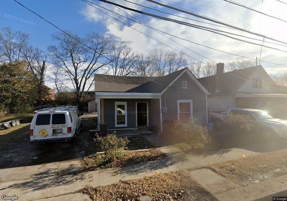
710 Lancaster Ave Lexington, KY 40508
William Wells Brown NeighborhoodEstimated Value: $143,000 - $206,000
3
Beds
2
Baths
1,042
Sq Ft
$176/Sq Ft
Est. Value
About This Home
This home is located at 710 Lancaster Ave, Lexington, KY 40508 and is currently estimated at $183,000, approximately $175 per square foot. 710 Lancaster Ave is a home located in Fayette County with nearby schools including William Wells Brown Elementary School, Lexington Traditional Magnet School, and Frederick Douglass High School.
Ownership History
Date
Name
Owned For
Owner Type
Purchase Details
Closed on
Apr 29, 2020
Sold by
Clem Frankie Lee and Clem Frankie Lee
Bought by
Nest A Lex Llc
Current Estimated Value
Purchase Details
Closed on
May 30, 2013
Sold by
Hoskins Siller
Bought by
Clem Frankie Lee and Clem Ada Mae
Home Financials for this Owner
Home Financials are based on the most recent Mortgage that was taken out on this home.
Original Mortgage
$25,966
Interest Rate
3.42%
Mortgage Type
Unknown
Create a Home Valuation Report for This Property
The Home Valuation Report is an in-depth analysis detailing your home's value as well as a comparison with similar homes in the area
Home Values in the Area
Average Home Value in this Area
Purchase History
| Date | Buyer | Sale Price | Title Company |
|---|---|---|---|
| Nest A Lex Llc | $22,500 | -- | |
| Clem Frankie Lee | $25,966 | -- |
Source: Public Records
Mortgage History
| Date | Status | Borrower | Loan Amount |
|---|---|---|---|
| Previous Owner | Clem Frankie Lee | $25,966 |
Source: Public Records
Tax History Compared to Growth
Tax History
| Year | Tax Paid | Tax Assessment Tax Assessment Total Assessment is a certain percentage of the fair market value that is determined by local assessors to be the total taxable value of land and additions on the property. | Land | Improvement |
|---|---|---|---|---|
| 2025 | $1,676 | $135,500 | $0 | $0 |
| 2024 | $1,676 | $135,500 | $0 | $0 |
| 2023 | $1,263 | $102,100 | $0 | $0 |
| 2022 | $287 | $22,500 | $0 | $0 |
| 2021 | $287 | $22,500 | $0 | $0 |
| 2020 | $824 | $64,500 | $0 | $0 |
| 2019 | $824 | $64,500 | $0 | $0 |
| 2018 | $511 | $40,000 | $0 | $0 |
| 2017 | $487 | $40,000 | $0 | $0 |
| 2015 | $67 | $40,000 | $0 | $0 |
| 2014 | $67 | $40,000 | $0 | $0 |
| 2012 | $67 | $40,000 | $0 | $0 |
Source: Public Records
Map
Nearby Homes
- 750 Maple Ave
- 650 N Martin Luther King Blvd
- 633 Ohio St
- 635 N Martin Luther King Blvd
- 150 York St
- 557 Chestnut St
- 818 Idlewild Ct
- 248 E Fifth St
- 714 Florida St
- 216 E Fifth St
- 569 N Upper St
- 443 Ohio St
- 275 E Fourth St
- 413 Chestnut St
- 423 Hawkins Ave
- 635 Breckenridge St
- 276 E Fourth St
- 433 E Fourth St
- 607 N Broadway
- 126 N Broadway Park
- 708 Lancaster Ave
- 712 Lancaster Ave
- 706 Lancaster Ave
- 714 Lancaster Ave
- 704 Lancaster Ave
- 716 Lancaster Ave
- 702 Lancaster Ave
- 713 Lancaster Ave
- 711 Lancaster Ave
- 715 Lancaster Ave
- 705 Lancaster Ave
- 717 Lancaster Ave
- 707 Lancaster Ave
- 301 E Seventh St
- 719 Lancaster Ave
- 721 Lancaster Ave
- 245 E 7th St
- 227 E Seventh St
- 670 Elm Tree Ln
- 733 Lancaster Ave