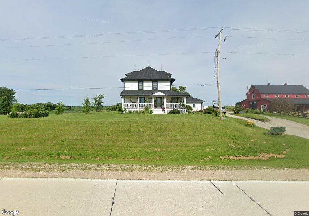
7106 N 10th St Marion, IA 52302
Estimated Value: $554,000 - $728,089
4
Beds
3
Baths
3,245
Sq Ft
$191/Sq Ft
Est. Value
About This Home
This home is located at 7106 N 10th St, Marion, IA 52302 and is currently estimated at $618,772, approximately $190 per square foot. 7106 N 10th St is a home located in Linn County with nearby schools including Novak Elementary School, Excelsior Middle School, and Linn-Mar High School.
Ownership History
Date
Name
Owned For
Owner Type
Purchase Details
Closed on
Feb 1, 2013
Sold by
Parsons Terry E
Bought by
Parsons Julie A
Current Estimated Value
Purchase Details
Closed on
Jul 1, 1998
Sold by
Bolson Loren Marlin
Bought by
Parsons Terry E and Parsons Julie Ann
Home Financials for this Owner
Home Financials are based on the most recent Mortgage that was taken out on this home.
Original Mortgage
$223,300
Outstanding Balance
$44,706
Interest Rate
6.75%
Estimated Equity
$574,066
Create a Home Valuation Report for This Property
The Home Valuation Report is an in-depth analysis detailing your home's value as well as a comparison with similar homes in the area
Home Values in the Area
Average Home Value in this Area
Purchase History
| Date | Buyer | Sale Price | Title Company |
|---|---|---|---|
| Parsons Julie A | -- | None Available | |
| Parsons Terry E | $253,500 | -- |
Source: Public Records
Mortgage History
| Date | Status | Borrower | Loan Amount |
|---|---|---|---|
| Open | Parsons Terry E | $223,300 |
Source: Public Records
Tax History Compared to Growth
Tax History
| Year | Tax Paid | Tax Assessment Tax Assessment Total Assessment is a certain percentage of the fair market value that is determined by local assessors to be the total taxable value of land and additions on the property. | Land | Improvement |
|---|---|---|---|---|
| 2025 | $7,076 | $568,200 | $119,000 | $449,200 |
| 2024 | $6,262 | $536,700 | $119,000 | $417,700 |
| 2023 | $6,262 | $536,700 | $119,000 | $417,700 |
| 2022 | $5,472 | $407,600 | $119,000 | $288,600 |
| 2021 | $5,572 | $369,000 | $119,000 | $250,000 |
| 2020 | $5,572 | $350,400 | $81,100 | $269,300 |
| 2019 | $5,246 | $330,900 | $81,100 | $249,800 |
| 2018 | $5,010 | $330,900 | $81,100 | $249,800 |
| 2017 | $5,163 | $329,500 | $81,100 | $248,400 |
| 2016 | $5,163 | $329,500 | $81,100 | $248,400 |
| 2015 | $5,203 | $329,500 | $81,100 | $248,400 |
| 2014 | $5,066 | $329,500 | $81,100 | $248,400 |
| 2013 | $4,862 | $329,500 | $81,100 | $248,400 |
Source: Public Records
Map
Nearby Homes
- 1789 Glen Rock Cir
- 1823 Glen Rock Cir
- 1605 Valentine Dr
- 2070 Royal Oak Ridge Rd
- 1727 Hunters Creek Way Unit 1727
- 2239 Royal Oak Ridge Rd
- 2027 Royal Oak Ridge Rd
- 2069 Royal Oak Ridge Rd
- 2155 Royal Oak Ridge Rd
- 1845 Hunters Creek Way Unit 1845
- 1600 Hunters Creek Way Unit 1600
- 1562 Hunters Creek Way Unit 1562
- 5524 Cimarron Ct
- 5936 Cedar Ridge Dr
- 1350 Huntington Hills Dr
- 5510 Hunters Ridge Ct
- 3456 Quartz Dr
- 2970 Covey Run Ct
- 2995 Royal Oak Ridge Rd
- 5760 Hertz Dr
- 7000 N 10th St
- 6925 White Gate Ct
- 6843 White Gate Ct
- 6890 White Gate Ct
- 6763 White Gate Ct
- 6684 White Gate Ct
- 6600 N 10th St
- 6691 White Gate Ct
- 6601 White Gate Ct
- 6550 White Gate Ct
- 6551 White Gate Ct
- 6500 White Gate Ct
- 6404 N 10th St
- 6501 White Gate Ct
- 6450 White Gate Ct
- 6310 N 10th St
- 6451 White Gate Ct
- 6400 White Gate Ct
- 6401 White Gate Ct
- 1493 Glen Rock Cir