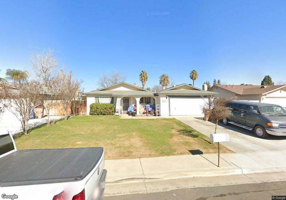
7116 Cedarcrest Ave Bakersfield, CA 93308
Olive Drive Area NeighborhoodEstimated Value: $398,000 - $499,000
4
Beds
2
Baths
1,602
Sq Ft
$271/Sq Ft
Est. Value
About This Home
This home is located at 7116 Cedarcrest Ave, Bakersfield, CA 93308 and is currently estimated at $434,826, approximately $271 per square foot. 7116 Cedarcrest Ave is a home located in Kern County with nearby schools including Olive Drive Elementary School, Norris Middle School, and Centennial High School.
Ownership History
Date
Name
Owned For
Owner Type
Purchase Details
Closed on
Apr 9, 2003
Sold by
Goodman Jimmy A and Goodman Dorothy E
Bought by
Terrell Christopher and Terrell Joyce
Current Estimated Value
Home Financials for this Owner
Home Financials are based on the most recent Mortgage that was taken out on this home.
Original Mortgage
$150,000
Outstanding Balance
$64,534
Interest Rate
5.77%
Mortgage Type
Purchase Money Mortgage
Estimated Equity
$370,292
Create a Home Valuation Report for This Property
The Home Valuation Report is an in-depth analysis detailing your home's value as well as a comparison with similar homes in the area
Home Values in the Area
Average Home Value in this Area
Purchase History
| Date | Buyer | Sale Price | Title Company |
|---|---|---|---|
| Terrell Christopher | $150,000 | Stewart Title |
Source: Public Records
Mortgage History
| Date | Status | Borrower | Loan Amount |
|---|---|---|---|
| Open | Terrell Christopher | $150,000 |
Source: Public Records
Tax History Compared to Growth
Tax History
| Year | Tax Paid | Tax Assessment Tax Assessment Total Assessment is a certain percentage of the fair market value that is determined by local assessors to be the total taxable value of land and additions on the property. | Land | Improvement |
|---|---|---|---|---|
| 2025 | $3,203 | $232,326 | $55,024 | $177,302 |
| 2024 | $3,136 | $227,772 | $53,946 | $173,826 |
| 2023 | $3,136 | $223,307 | $52,889 | $170,418 |
| 2022 | $3,066 | $218,930 | $51,852 | $167,078 |
| 2021 | $2,982 | $214,638 | $50,836 | $163,802 |
| 2020 | $2,889 | $212,438 | $50,315 | $162,123 |
| 2019 | $2,847 | $212,438 | $50,315 | $162,123 |
| 2018 | $2,753 | $204,191 | $48,362 | $155,829 |
| 2017 | $2,762 | $200,188 | $47,414 | $152,774 |
| 2016 | $2,578 | $196,264 | $46,485 | $149,779 |
| 2015 | $2,535 | $193,317 | $45,787 | $147,530 |
| 2014 | $2,476 | $189,532 | $44,891 | $144,641 |
Source: Public Records
Map
Nearby Homes
- 6801 Mignonette St
- 7400 Petris Ave
- 7116 Jolynn St
- 6708 Cranbrook Ave
- 6709 Cedarcrest Ave
- 6300 Mignonette St
- 7513 Terry John Ave
- 7704 Jill Jean Ave
- 6710 Pinecone Ave
- 6600 Cedarcrest Ave
- 7108 Luke Ave
- 7716 Canfield Ct
- 7207 Briar Ridge Ct
- 6918 Crestwood St
- 7309 Angela Ave
- 7009 Etter St
- 6600 Audene Way
- 6418 Abby Rose Ave
- 6816 Coffee Rd
- 7918 Date Palm Ct
- 7112 Cedarcrest Ave
- 7200 Cedarcrest Ave
- 7108 Cedarcrest Ave
- 7204 Cedarcrest Ave
- 7117 Cranbrook Ave
- 7100 Cedarcrest Ave
- 7208 Cedarcrest Ave
- 7201 Cranbrook Ave
- 7113 Cranbrook Ave
- 7109 Cranbrook Ave
- 7205 Cranbrook Ave
- 7117 Cedarcrest Ave
- 7201 Cedarcrest Ave
- 7113 Cedarcrest Ave
- 7212 Cedarcrest Ave
- 7101 Cranbrook Ave
- 7209 Cranbrook Ave
- 7205 Cedarcrest Ave
- 7109 Cedarcrest Ave
- 7209 Cedarcrest Ave