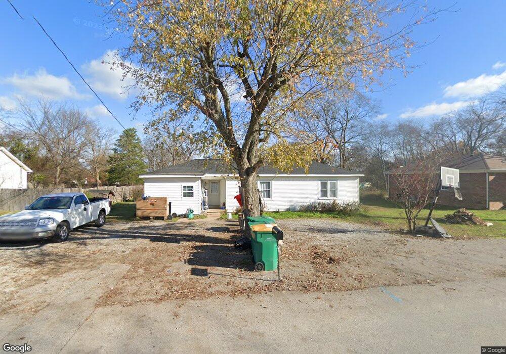
712 Crestland St Lewisburg, TN 37091
Estimated Value: $165,618 - $235,000
--
Bed
1
Bath
1,343
Sq Ft
$145/Sq Ft
Est. Value
About This Home
This home is located at 712 Crestland St, Lewisburg, TN 37091 and is currently estimated at $194,405, approximately $144 per square foot. 712 Crestland St is a home located in Marshall County with nearby schools including Marshall Elementary School, Oak Grove Elementary School, and Westhills Elementary School.
Ownership History
Date
Name
Owned For
Owner Type
Purchase Details
Closed on
Mar 24, 2006
Sold by
Catalino Aramda
Bought by
Reza Rogel Emilio
Current Estimated Value
Home Financials for this Owner
Home Financials are based on the most recent Mortgage that was taken out on this home.
Original Mortgage
$51,000
Outstanding Balance
$28,925
Interest Rate
6.23%
Estimated Equity
$165,480
Purchase Details
Closed on
Jul 3, 2003
Sold by
Marsha Coble
Bought by
Catalino Aranda
Purchase Details
Closed on
Dec 6, 2002
Sold by
Gordon Dyer Robert
Bought by
Marsha Cole
Create a Home Valuation Report for This Property
The Home Valuation Report is an in-depth analysis detailing your home's value as well as a comparison with similar homes in the area
Home Values in the Area
Average Home Value in this Area
Purchase History
| Date | Buyer | Sale Price | Title Company |
|---|---|---|---|
| Reza Rogel Emilio | $60,000 | -- | |
| Catalino Aranda | $59,900 | -- | |
| Marsha Cole | $44,000 | -- |
Source: Public Records
Mortgage History
| Date | Status | Borrower | Loan Amount |
|---|---|---|---|
| Open | Marsha Cole | $51,000 |
Source: Public Records
Tax History Compared to Growth
Tax History
| Year | Tax Paid | Tax Assessment Tax Assessment Total Assessment is a certain percentage of the fair market value that is determined by local assessors to be the total taxable value of land and additions on the property. | Land | Improvement |
|---|---|---|---|---|
| 2024 | -- | $31,925 | $7,000 | $24,925 |
| 2023 | $991 | $31,925 | $7,000 | $24,925 |
| 2022 | $991 | $31,925 | $7,000 | $24,925 |
| 2021 | $867 | $18,650 | $3,500 | $15,150 |
| 2020 | $710 | $15,275 | $3,500 | $11,775 |
| 2019 | $687 | $15,275 | $3,500 | $11,775 |
| 2018 | $680 | $15,275 | $3,500 | $11,775 |
| 2017 | $680 | $15,275 | $3,500 | $11,775 |
| 2016 | $730 | $14,250 | $3,375 | $10,875 |
| 2015 | $665 | $14,250 | $3,375 | $10,875 |
| 2014 | $665 | $14,250 | $3,375 | $10,875 |
Source: Public Records
Map
Nearby Homes
- 755 Center St
- 301 East Ave
- 224 Hardison Ave
- 126 Armory Dr
- 125 Armory Dr
- 535 Clayton Ave
- 330 Hickory Cir
- 411 Elm Ave
- 391 Elm Ave
- 131 Isabela Dr
- 141 Isabela Dr
- 319 E Hill Ave
- 380 Baxter Ave
- 188 Trey Dr
- 1351 Old Belfast Rd
- 155 Landon Ln
- 3019 Cambridge Ct
- 3021 Cambridge Ct
- 1183 Finley Beech Rd
- 416 1st Ave N
- 720 Crestland St
- 690 Crestland St
- 728 Crestland St
- 719 Crestland St
- 691 Crestland St
- 686 Crestland St
- 693 Crestland St
- 738 Crestland St
- 725 Crestland St
- 721 Crestland St
- 511 Hardison Ave
- 682 Crestland St
- 743 Belfast St
- 737 Belfast St
- 735 Crestland St
- 749 Belfast St
- 680 Crestland St
- 755 Belfast St
- 729 Belfast St
- 745 Crestland St