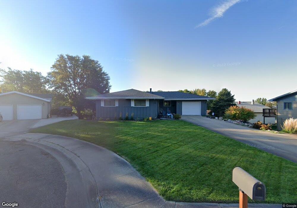
712 N Monroe Ave Pierre, SD 57501
Estimated Value: $297,905 - $348,000
3
Beds
3
Baths
1,202
Sq Ft
$262/Sq Ft
Est. Value
About This Home
This home is located at 712 N Monroe Ave, Pierre, SD 57501 and is currently estimated at $315,226, approximately $262 per square foot. 712 N Monroe Ave is a home with nearby schools including T.F. Riggs High School and Pierre SDA School.
Ownership History
Date
Name
Owned For
Owner Type
Purchase Details
Closed on
Oct 3, 2008
Sold by
George-Larson Shannon M
Bought by
Keyes James R and Keyes Tracy M
Current Estimated Value
Home Financials for this Owner
Home Financials are based on the most recent Mortgage that was taken out on this home.
Original Mortgage
$222,000
Interest Rate
6.41%
Create a Home Valuation Report for This Property
The Home Valuation Report is an in-depth analysis detailing your home's value as well as a comparison with similar homes in the area
Home Values in the Area
Average Home Value in this Area
Purchase History
| Date | Buyer | Sale Price | Title Company |
|---|---|---|---|
| Keyes James R | $160,000 | -- |
Source: Public Records
Mortgage History
| Date | Status | Borrower | Loan Amount |
|---|---|---|---|
| Closed | Keyes James R | $222,000 |
Source: Public Records
Tax History
| Year | Tax Paid | Tax Assessment Tax Assessment Total Assessment is a certain percentage of the fair market value that is determined by local assessors to be the total taxable value of land and additions on the property. | Land | Improvement |
|---|---|---|---|---|
| 2025 | $3,392 | $284,430 | $60,999 | $223,431 |
| 2024 | $3,383 | $273,790 | $60,999 | $212,791 |
| 2023 | $3,111 | $265,973 | $58,372 | $207,601 |
| 2022 | $2,929 | $228,593 | $55,592 | $173,001 |
| 2021 | $2,870 | $204,101 | $49,636 | $154,465 |
| 2020 | $2,937 | $198,156 | $48,190 | $149,966 |
| 2019 | $2,932 | $198,156 | $48,190 | $149,966 |
| 2018 | $2,809 | $192,384 | $46,786 | $145,598 |
| 2017 | -- | $183,223 | $44,558 | $138,665 |
| 2016 | $2,939 | $183,223 | $44,558 | $138,665 |
| 2015 | -- | $177,886 | $43,260 | $134,626 |
| 2014 | -- | $172,705 | $42,000 | $130,705 |
| 2013 | -- | $172,705 | $42,000 | $130,705 |
| 2011 | -- | $170,265 | $47,580 | $122,685 |
Source: Public Records
Map
Nearby Homes
- 620 N Harrison Ave
- TBD Lilac Dr
- 726 N Taylor Ave
- 212 N Van Buren Ave
- 601 Yucca Dr
- 203 N Tyler Ave
- 313 N Taylor Ave
- 2004 Buffalo St
- 111 N Harrison Ave
- 1511 E Capitol Ave
- 1515 E Capitol Ave
- 2106 Antelope St
- 119 S Tyler Ave
- 0 Woodview Dr
- 302 E Wynoka St
- 338 N Highland Ave
- 109 Baja Dr
- 137 Hampton Dr
- 139 Hampton Dr
- 219 N Highland Ave
- 710 N Monroe Ave
- 714 N Monroe Ave
- 706 N Monroe Ave
- 704 N Monroe Ave
- 624 N Jackson Ave
- 804 N Monroe Ave
- 716 N Monroe Ave
- 720 N Monroe Ave
- 620 N Jackson Ave
- 718 N Monroe Ave
- 707 N Monroe Ave
- 711 N Monroe Ave
- 808 N Monroe Ave
- 614 N Jackson Ave
- 803 N Monroe Ave
- 703 N Monroe Ave
- 623 N Jackson Ave
- 807 N Monroe Ave
- 627 N Jackson Ave
- 610 N Jackson Ave
Your Personal Tour Guide
Ask me questions while you tour the home.