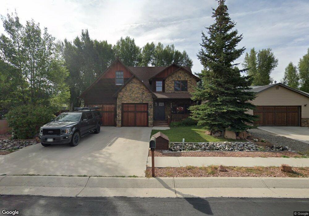
713 Andrew Ln Gunnison, CO 81230
Estimated Value: $891,000 - $1,174,000
3
Beds
4
Baths
2,624
Sq Ft
$370/Sq Ft
Est. Value
About This Home
This home is located at 713 Andrew Ln, Gunnison, CO 81230 and is currently estimated at $969,623, approximately $369 per square foot. 713 Andrew Ln is a home located in Gunnison County with nearby schools including Gunnison Elementary School, Gunnison Middle School, and Crested Butte Community School.
Ownership History
Date
Name
Owned For
Owner Type
Purchase Details
Closed on
Oct 5, 2020
Sold by
Jacobs Paul and Jacobs Elida
Bought by
Shondeck Scott Robert and Shondeck Lauren Elizabeth
Current Estimated Value
Home Financials for this Owner
Home Financials are based on the most recent Mortgage that was taken out on this home.
Original Mortgage
$496,000
Outstanding Balance
$441,166
Interest Rate
2.9%
Mortgage Type
New Conventional
Estimated Equity
$528,457
Purchase Details
Closed on
Jul 17, 2007
Sold by
Gunnison Investments Llc
Bought by
Jacobs Paul L
Create a Home Valuation Report for This Property
The Home Valuation Report is an in-depth analysis detailing your home's value as well as a comparison with similar homes in the area
Home Values in the Area
Average Home Value in this Area
Purchase History
| Date | Buyer | Sale Price | Title Company |
|---|---|---|---|
| Shondeck Scott Robert | $620,000 | Gunnison County Abstract Co | |
| Jacobs Paul L | $62,500 | Stewart Title Of Colorado |
Source: Public Records
Mortgage History
| Date | Status | Borrower | Loan Amount |
|---|---|---|---|
| Open | Shondeck Scott Robert | $496,000 |
Source: Public Records
Tax History Compared to Growth
Tax History
| Year | Tax Paid | Tax Assessment Tax Assessment Total Assessment is a certain percentage of the fair market value that is determined by local assessors to be the total taxable value of land and additions on the property. | Land | Improvement |
|---|---|---|---|---|
| 2024 | $2,465 | $51,180 | $9,670 | $41,510 |
| 2023 | $2,465 | $47,490 | $8,970 | $38,520 |
| 2022 | $2,793 | $46,920 | $4,870 | $42,050 |
| 2021 | $2,516 | $48,270 | $5,010 | $43,260 |
| 2020 | $2,135 | $38,610 | $4,080 | $34,530 |
| 2019 | -- | $38,610 | $4,080 | $34,530 |
| 2018 | -- | $31,850 | $2,660 | $29,190 |
| 2017 | -- | $31,850 | $2,660 | $29,190 |
| 2016 | -- | $35,350 | $2,790 | $32,560 |
Source: Public Records
Map
Nearby Homes
- 706 Andrew Ln
- 700 U S 50
- Lots 13-16 Us Highway 50 Frontage Rd
- 300 Bevington Rd
- 301 S 2nd St Unit 68
- 314 S 5th St
- TBD S 6th St
- 302 S 5th St
- 1412 W Gunnison Ave
- 215 S 7th St
- 288 S 5th St
- 137 Park Dr
- 133 Park Dr
- 1511 W Tomichi Ave
- 107 Wildrose Ln
- 1709 W Tomichi Ave
- 1208 W Tomichi Ave Unit 4
- 109 N 7th St
- 1314 W Tomichi Ave Unit 9
- 417 S Boulevard St Unit B
- 711 Andrew Ln
- 715 Andrew Ln
- 709 Andrew Ln
- 717 Andrew Ln
- 707 Andrew Ln
- 808 W Us Highway 50
- 802 W Us Highway 50
- 719 Andrew Ln
- 712 Andrew Ln
- 714 Andrew Ln
- 716 Andrew Ln
- 708 Andrew Ln
- 810 W Us Highway 50
- 705 Andrew Ln
- 718 Andrew Ln Unit Corner of Thorton Wa
- 721 Andrew Ln
- 1568 Thornton Way
- 703 Andrew Ln
- 703 Andrew Ln Unit (West Side by Old Dr
- 700 W Us Highway 50