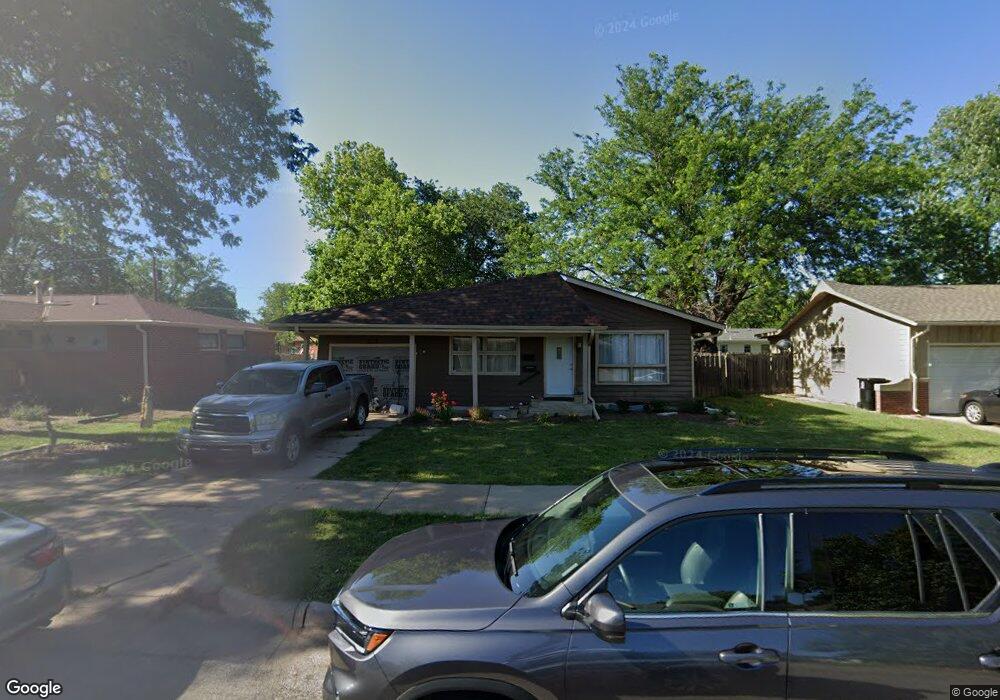
713 Carl Ave Salina, KS 67401
Estimated Value: $181,689 - $207,000
3
Beds
3
Baths
1,520
Sq Ft
$132/Sq Ft
Est. Value
About This Home
This home is located at 713 Carl Ave, Salina, KS 67401 and is currently estimated at $199,922, approximately $131 per square foot. 713 Carl Ave is a home located in Saline County with nearby schools including Stewart Elementary School, Salina South Middle School, and Salina High School South.
Ownership History
Date
Name
Owned For
Owner Type
Purchase Details
Closed on
Oct 18, 2011
Sold by
Federal National Mortgage Association
Bought by
Medellin-Ortiz Fernando J
Current Estimated Value
Home Financials for this Owner
Home Financials are based on the most recent Mortgage that was taken out on this home.
Original Mortgage
$77,000
Outstanding Balance
$52,618
Interest Rate
4.14%
Mortgage Type
Purchase Money Mortgage
Estimated Equity
$147,304
Create a Home Valuation Report for This Property
The Home Valuation Report is an in-depth analysis detailing your home's value as well as a comparison with similar homes in the area
Home Values in the Area
Average Home Value in this Area
Purchase History
| Date | Buyer | Sale Price | Title Company |
|---|---|---|---|
| Medellin-Ortiz Fernando J | -- | Stewart Title |
Source: Public Records
Mortgage History
| Date | Status | Borrower | Loan Amount |
|---|---|---|---|
| Open | Medellin-Ortiz Fernando J | $77,000 |
Source: Public Records
Tax History Compared to Growth
Tax History
| Year | Tax Paid | Tax Assessment Tax Assessment Total Assessment is a certain percentage of the fair market value that is determined by local assessors to be the total taxable value of land and additions on the property. | Land | Improvement |
|---|---|---|---|---|
| 2025 | $2,254 | $16,468 | $1,601 | $14,867 |
| 2024 | $2,254 | $17,434 | $2,231 | $15,203 |
| 2023 | $2,254 | $18,228 | $2,159 | $16,069 |
| 2022 | $2,571 | $19,619 | $2,018 | $17,601 |
| 2021 | $2,120 | $15,617 | $1,965 | $13,652 |
| 2020 | $2,207 | $16,054 | $2,125 | $13,929 |
| 2019 | $1,973 | $16,514 | $2,200 | $14,314 |
| 2018 | $1,983 | $14,663 | $2,200 | $12,463 |
| 2017 | $0 | $14,329 | $2,014 | $12,315 |
| 2016 | $0 | $13,685 | $2,014 | $11,671 |
| 2015 | -- | $12,742 | $2,006 | $10,736 |
| 2013 | -- | $0 | $0 | $0 |
Source: Public Records
Map
Nearby Homes
- 639 Ralph Ave
- 1908 Marc St
- 1201 Wet Stone Dr
- 2037 Roach St
- 2053 Quincy St
- 813 E Claflin Ave
- 1418 Sunrise Dr
- 1820 Glendale Rd
- 220 E Ellsworth Ave
- 1307 Parkwood Dr
- 1100 Quincy St
- 1325 Lynn Dr
- 237 E Minneapolis Ave
- 2162 S Ohio St
- 2211 S Ohio St
- 952 Pearl Ave
- 1301 E Ellsworth Ave
- 717 Morningside Dr
- 1218 E Beloit Ave
- 1402 S 9th St