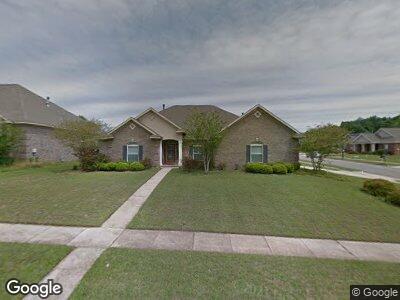
7130 Saybrook Blvd Unit 1 Mobile, AL 36619
Travis NeighborhoodEstimated Value: $315,319 - $386,000
4
Beds
3
Baths
2,502
Sq Ft
$143/Sq Ft
Est. Value
About This Home
This home is located at 7130 Saybrook Blvd Unit 1, Mobile, AL 36619 and is currently estimated at $357,080, approximately $142 per square foot. 7130 Saybrook Blvd Unit 1 is a home located in Mobile County with nearby schools including Meadowlake Elementary School, Burns Middle School, and WP Davidson High School.
Ownership History
Date
Name
Owned For
Owner Type
Purchase Details
Closed on
Dec 27, 2010
Sold by
Jbl Properties Ltd
Bought by
Ngo Phat T and Ngo Thai T
Current Estimated Value
Home Financials for this Owner
Home Financials are based on the most recent Mortgage that was taken out on this home.
Original Mortgage
$180,000
Interest Rate
4.42%
Mortgage Type
New Conventional
Purchase Details
Closed on
Nov 14, 2003
Sold by
Mcinnis Llc
Bought by
Jbl Properties Ltd
Create a Home Valuation Report for This Property
The Home Valuation Report is an in-depth analysis detailing your home's value as well as a comparison with similar homes in the area
Home Values in the Area
Average Home Value in this Area
Purchase History
| Date | Buyer | Sale Price | Title Company |
|---|---|---|---|
| Ngo Phat T | $225,000 | None Available | |
| Jbl Properties Ltd | -- | -- |
Source: Public Records
Mortgage History
| Date | Status | Borrower | Loan Amount |
|---|---|---|---|
| Open | Ngo Phat T | $125,000 | |
| Closed | Ngo Phat T | $180,000 |
Source: Public Records
Tax History Compared to Growth
Tax History
| Year | Tax Paid | Tax Assessment Tax Assessment Total Assessment is a certain percentage of the fair market value that is determined by local assessors to be the total taxable value of land and additions on the property. | Land | Improvement |
|---|---|---|---|---|
| 2024 | $1,461 | $29,020 | $4,350 | $24,670 |
| 2023 | $1,461 | $27,200 | $4,350 | $22,850 |
| 2022 | $1,134 | $24,740 | $4,350 | $20,390 |
| 2021 | $1,072 | $23,460 | $4,350 | $19,110 |
| 2020 | $1,082 | $23,690 | $4,350 | $19,340 |
| 2019 | $992 | $21,840 | $0 | $0 |
| 2018 | $1,003 | $22,060 | $0 | $0 |
| 2017 | $988 | $21,760 | $0 | $0 |
| 2016 | $998 | $21,960 | $0 | $0 |
| 2013 | $1,054 | $22,920 | $0 | $0 |
Source: Public Records
Map
Nearby Homes
- 7170 Pierson Dr
- 3853 Dwight Ct
- 7303 Saybrook Blvd Unit 1
- 4000 Fenwick Loop W
- 4150 Oakbriar Dr E
- 3843 Pierson Dr W
- 0 Mill House Dr N Unit 7553176
- 0 Mill House Dr N Unit 376890
- 7155 Mill House Dr N
- 7227 Mill House Dr S
- 0 Mill House Dr S Unit 7507184
- 0 Mill House Dr S Unit 7507180
- 0 Mill House Dr S Unit 7450314
- 0 Mill House Dr S Unit 7450430
- 4250 Tara Dr W
- 3480 Sollie Rd
- 7601 Meadows Dr S
- 0 Raleigh Way Unit 7526650
- 4251 Honey Ct
- 3200 Long Leaf Way
- 7130 Saybrook Blvd Unit 1
- 7140 Saybrook Blvd
- 3900 Branford Ct
- 3890 Branford Ct
- 3931 Branford Ct
- 3921 Branford Ct
- 7150 Saybrook Blvd
- 7125 Saybrook Blvd
- 3911 Branford Ct
- 7135 Saybrook Blvd
- 3880 Branford Ct
- 3901 Branford Ct
- 3915 Trumbull Ct
- 7145 Saybrook Blvd
- 3891 Branford Ct
- 7160 Saybrook Blvd
- 3870 Branford Ct
- 3905 Trumbull Ct
- 7155 Saybrook Blvd
- 7130 Pierson Dr