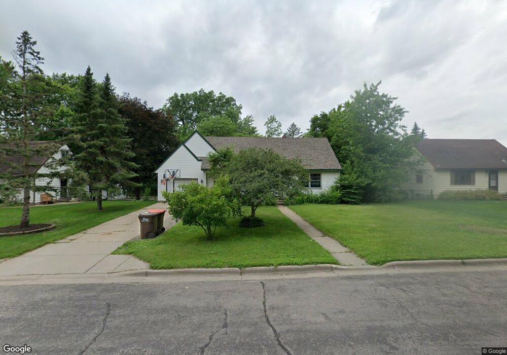
715 Ashland Ave St. Paul Park, MN 55071
Estimated Value: $277,000 - $307,000
3
Beds
2
Baths
1,139
Sq Ft
$256/Sq Ft
Est. Value
About This Home
This home is located at 715 Ashland Ave, St. Paul Park, MN 55071 and is currently estimated at $291,370, approximately $255 per square foot. 715 Ashland Ave is a home located in Washington County with nearby schools including Pullman Elementary School, Oltman Middle School, and Park Senior High School.
Ownership History
Date
Name
Owned For
Owner Type
Purchase Details
Closed on
Jul 26, 2010
Sold by
Wells Fargo Financial Minnesota Inc
Bought by
Hunter James A and Hunter Teri C
Current Estimated Value
Purchase Details
Closed on
Oct 16, 1987
Sold by
Bilski John R and Bilski Twyla
Bought by
Fitzgerald Patrick M and Fitzgerald Thela D
Create a Home Valuation Report for This Property
The Home Valuation Report is an in-depth analysis detailing your home's value as well as a comparison with similar homes in the area
Home Values in the Area
Average Home Value in this Area
Purchase History
| Date | Buyer | Sale Price | Title Company |
|---|---|---|---|
| Hunter James A | $80,000 | -- | |
| Fitzgerald Patrick M | $62,900 | -- |
Source: Public Records
Mortgage History
| Date | Status | Borrower | Loan Amount |
|---|---|---|---|
| Closed | Fitzgerald Patrick M | -- | |
| Closed | Fitzgerald Patrick M | $17,500 |
Source: Public Records
Tax History Compared to Growth
Tax History
| Year | Tax Paid | Tax Assessment Tax Assessment Total Assessment is a certain percentage of the fair market value that is determined by local assessors to be the total taxable value of land and additions on the property. | Land | Improvement |
|---|---|---|---|---|
| 2024 | $3,412 | $254,800 | $80,000 | $174,800 |
| 2023 | $3,412 | $259,100 | $92,000 | $167,100 |
| 2022 | $2,932 | $248,300 | $91,300 | $157,000 |
| 2021 | $2,798 | $206,900 | $76,000 | $130,900 |
| 2020 | $2,718 | $200,400 | $76,000 | $124,400 |
| 2019 | $2,670 | $191,800 | $67,000 | $124,800 |
| 2018 | $2,322 | $176,700 | $63,000 | $113,700 |
| 2017 | $2,146 | $153,200 | $54,000 | $99,200 |
| 2016 | $2,174 | $144,200 | $49,000 | $95,200 |
| 2015 | $2,030 | $144,200 | $56,000 | $88,200 |
| 2013 | -- | $122,400 | $46,400 | $76,000 |
Source: Public Records
Map
Nearby Homes
- 801 Summit Ave
- 1033 Portland Ave
- TBD Broadway Ave
- 6444 Genevieve Trail
- 1200 Summit Ave
- 6538 Genevieve Trail
- 6745 Wildflower Dr S
- 6283 Highland Hills Ln S
- 11XX 1st St
- 6266 Highland Hills Ln S
- 6291 Highland Hills Ln S
- 6295 Highland Hills Ln S
- 6284 Highland Hills Ln S
- 1637 Pullman Ave
- 6290 Highland Hills Ln S
- 6296 Highland Hills Ln S
- 6219 64th St S
- 1142 1st St
- 6300 Highland Hills Ln S
- Mercer Plan at Hawthorne - Expressions
- 715 Ashland Ave
- 729 Ashland Ave
- 701 Ashland Ave
- 715 715 Ashland-Avenue-
- 701 Ashland Ave
- 743 Ashland Ave
- 714 Holley Ave
- 728 Holley Ave
- 700 Holley Ave
- 757 Ashland Ave
- 742 Holley Ave
- 742 Ashland Ave
- 756 Holley Ave
- 756 Ashland Ave
- 700 Hastings Ave
- 756 Holley Ave
- 640 Hastings Ave
- 770 Holley Ave
- 770 Ashland Ave
- 785 Ashland Ave