Estimated payment $2,922/month
Highlights
- Deck
- Traditional Architecture
- Main Floor Primary Bedroom
- Property is near public transit
- Wood Flooring
- High Ceiling
About This Home
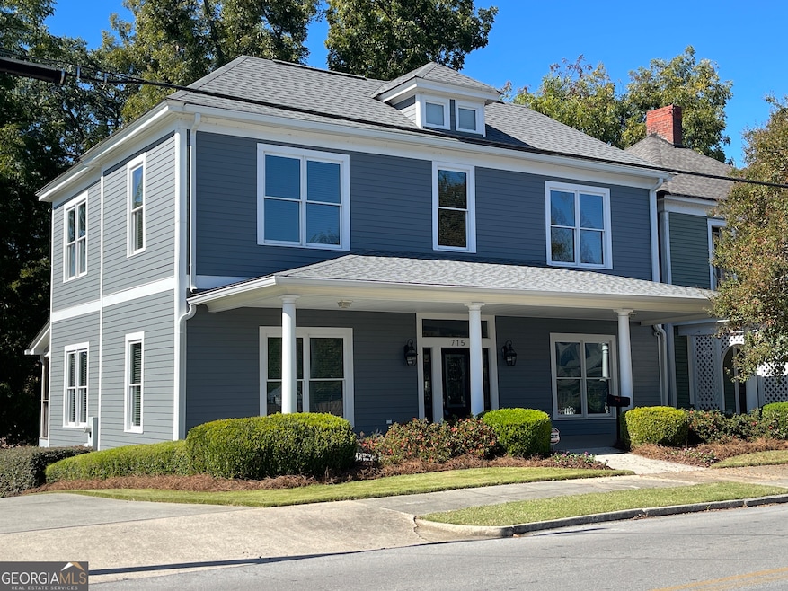
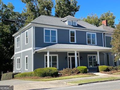
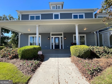
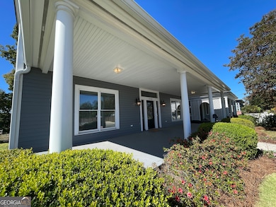
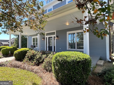
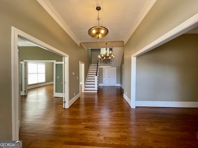
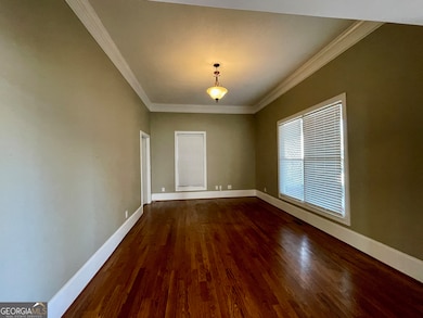
Now available in the heart of Rome, this beautifully restored 1910 historic home blends timeless charm with modern comfort. The Morrison House, a 4-bedroom, 2-bath residence was fully remodeled in 2012 and located minutes from downtown, dining, shopping, trail system and entertainment. Featuring 12-foot ceilings, hardwood floors, stunning staircase, kitchen w/SS appliances, Cat5 internet, and elegant architectural details. Freshly painted and move-in ready with off-street parking and private backyard. This unique home could easily be rezoned for office use, offering excellent potential for a professional space in a high-visibility, central location - or simply enjoy it as a one-of-a-kind intown residence. Historically significant, this is the birthplace of Admiral George Stephen Morrison, a highly decorated U.S. Naval officer credited with saving thousands of lives and best known as the father of Jim Morrison, legendary frontman of The Doors. Don't miss this rare opportunity to own a true piece of American history.
Home Details
Home Type
- Single Family
Est. Annual Taxes
- $5,167
Year Built
- Built in 1910 | Remodeled
Lot Details
- 7,405 Sq Ft Lot
- Level Lot
- Sprinkler System
Home Design
- Traditional Architecture
- Block Foundation
- Composition Roof
- Concrete Siding
Interior Spaces
- 2,604 Sq Ft Home
- 2-Story Property
- High Ceiling
- Double Pane Windows
- Window Treatments
- Entrance Foyer
- Family Room
- Breakfast Room
- Formal Dining Room
- Laundry on upper level
Kitchen
- Oven or Range
- Microwave
- Dishwasher
- Solid Surface Countertops
Flooring
- Wood
- Tile
Bedrooms and Bathrooms
- 4 Bedrooms | 1 Primary Bedroom on Main
- Walk-In Closet
- Bathtub Includes Tile Surround
Unfinished Basement
- Exterior Basement Entry
- Dirt Floor
Home Security
- Home Security System
- Fire and Smoke Detector
Parking
- Parking Pad
- Off-Street Parking
Accessible Home Design
- Accessible Full Bathroom
- Accessible Kitchen
- Accessible Hallway
- Accessible Doors
- Low Door Handles
- Accessible Approach with Ramp
- Accessible Entrance
Outdoor Features
- Deck
- Porch
Location
- Property is near public transit
- Property is near shops
- City Lot
Schools
- Main Elementary School
- Rome Middle School
- Rome High School
Utilities
- Two cooling system units
- Central Heating and Cooling System
- Dual Heating Fuel
- Electric Water Heater
- High Speed Internet
- Phone Available
- Cable TV Available
Community Details
- No Home Owners Association
- Laundry Facilities
Listing and Financial Details
- Tax Lot 237
Map
Home Values in the Area
Average Home Value in this Area
Tax History
| Year | Tax Paid | Tax Assessment Tax Assessment Total Assessment is a certain percentage of the fair market value that is determined by local assessors to be the total taxable value of land and additions on the property. | Land | Improvement |
|---|---|---|---|---|
| 2024 | $5,573 | $145,897 | $8,378 | $137,519 |
| 2023 | $5,167 | $141,362 | $7,573 | $133,789 |
| 2022 | $4,330 | $118,667 | $6,284 | $112,383 |
| 2021 | $4,022 | $108,386 | $6,284 | $102,102 |
| 2020 | $3,201 | $85,554 | $4,834 | $80,720 |
| 2019 | $2,856 | $77,158 | $4,834 | $72,324 |
| 2018 | $2,716 | $73,379 | $4,834 | $68,545 |
| 2017 | $2,553 | $68,964 | $4,834 | $64,130 |
| 2016 | $2,519 | $67,840 | $4,800 | $63,040 |
| 2015 | $2,448 | $68,640 | $4,800 | $63,840 |
| 2014 | $2,448 | $69,480 | $4,800 | $64,680 |
Property History
| Date | Event | Price | List to Sale | Price per Sq Ft |
|---|---|---|---|---|
| 10/17/2025 10/17/25 | For Sale | $475,000 | -- | $182 / Sq Ft |
Purchase History
| Date | Type | Sale Price | Title Company |
|---|---|---|---|
| Warranty Deed | -- | -- | |
| Warranty Deed | $55,000 | -- | |
| Warranty Deed | $85,000 | -- | |
| Deed | $40,000 | -- | |
| Deed | -- | -- | |
| Deed | -- | -- | |
| Deed | -- | -- | |
| Deed | -- | -- |
Mortgage History
| Date | Status | Loan Amount | Loan Type |
|---|---|---|---|
| Previous Owner | $150,218 | FHA |
Source: Georgia MLS
MLS Number: 10626874
APN: J13Y-470
Disclaimer: Certain information contained herein is derived from information provided by parties other than Homes.com. All information provided is deemed reliable, but is not guaranteed to be accurate and should be independently verified.
![]() The data relating to real estate for sale on this web site comes in part from the Broker Reciprocity Program of Georgia MLS. Real estate listings held by brokerage firms other than Redfin are marked with the Broker Reciprocity logo and detailed information about them includes the name of the listing brokers. Information deemed reliable but not guaranteed. Copyright 2025 Georgia MLS. All rights reserved.
The data relating to real estate for sale on this web site comes in part from the Broker Reciprocity Program of Georgia MLS. Real estate listings held by brokerage firms other than Redfin are marked with the Broker Reciprocity logo and detailed information about them includes the name of the listing brokers. Information deemed reliable but not guaranteed. Copyright 2025 Georgia MLS. All rights reserved.
- 601 W 10th St NE
- 1006 Avenue A NE
- Lot #1 Martha Berry Hwy
- 1005 N 2nd Ave NW
- 1005 N 2nd Ave NW Unit 31
- 8 E 3rd Ave
- 10 E 3rd Ave
- 213 Iron St NW
- 407 E 3rd St
- 202 E 4th Ave Unit 5
- 202 E 4th Ave
- 110 Smith St NE
- 102 Smith St NE
- 138 E 8th Ave Unit 25
- 312 E 3rd St
- 214 E 3rd St
- 13 Heard St NE
- 15 Heard St
- 31 Ross St NE
- 712 Avenue A NE
- 340 W 3rd St SW
- 525 W 13th St NE
- 1005 N 2nd Ave NW Unit 32
- 1005 N 2nd Ave NW
- 1005 N 2nd Ave NW Unit 33
- 1005 N 2nd Ave NW Unit 39
- 1005 N 2nd Ave NW Unit 35
- 507 E 2nd St Unit 3
- 204 Smith St NE Unit 206A
- 114 Broad St Unit 208
- 7 Myrtle St SW
- 108 Oakwood St NW
- 204 Oakwood St NW
- 111 Charlton St NW
- 707 E 2nd Ave
- 3 Fair St SW Unit A
- 12 Morningside Dr SW
- 812 Darlington Way SW
- 24 Riverpoint Place
