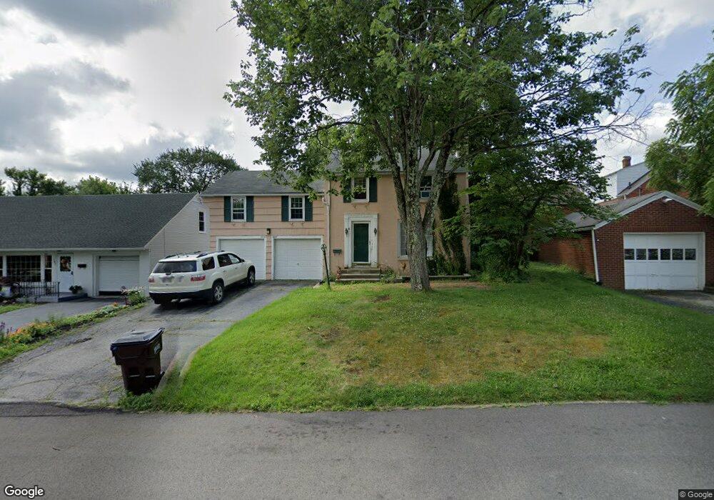
715 Barnard Ave Mansfield, OH 44903
Estimated Value: $171,000 - $195,000
4
Beds
2
Baths
1,663
Sq Ft
$107/Sq Ft
Est. Value
About This Home
This home is located at 715 Barnard Ave, Mansfield, OH 44903 and is currently estimated at $178,146, approximately $107 per square foot. 715 Barnard Ave is a home located in Richland County with nearby schools including Discovery School and St. Peter's Junior High / High School.
Ownership History
Date
Name
Owned For
Owner Type
Purchase Details
Closed on
Jun 26, 1997
Sold by
Porte Donna J
Bought by
Ballard Margaret L
Current Estimated Value
Home Financials for this Owner
Home Financials are based on the most recent Mortgage that was taken out on this home.
Original Mortgage
$57,464
Outstanding Balance
$8,602
Interest Rate
8%
Mortgage Type
FHA
Estimated Equity
$169,544
Purchase Details
Closed on
Mar 29, 1991
Sold by
Metzger David A
Bought by
Porter Donna J
Create a Home Valuation Report for This Property
The Home Valuation Report is an in-depth analysis detailing your home's value as well as a comparison with similar homes in the area
Home Values in the Area
Average Home Value in this Area
Purchase History
| Date | Buyer | Sale Price | Title Company |
|---|---|---|---|
| Ballard Margaret L | $62,450 | -- | |
| Porter Donna J | $60,000 | -- |
Source: Public Records
Mortgage History
| Date | Status | Borrower | Loan Amount |
|---|---|---|---|
| Open | Ballard Margaret L | $57,464 |
Source: Public Records
Tax History
| Year | Tax Paid | Tax Assessment Tax Assessment Total Assessment is a certain percentage of the fair market value that is determined by local assessors to be the total taxable value of land and additions on the property. | Land | Improvement |
|---|---|---|---|---|
| 2024 | $1,772 | $38,700 | $3,510 | $35,190 |
| 2023 | $1,812 | $38,700 | $3,510 | $35,190 |
| 2022 | $1,537 | $27,500 | $3,010 | $24,490 |
| 2021 | $1,547 | $27,500 | $3,010 | $24,490 |
| 2020 | $1,582 | $27,500 | $3,010 | $24,490 |
| 2019 | $1,753 | $27,500 | $3,010 | $24,490 |
| 2018 | $1,729 | $27,500 | $3,010 | $24,490 |
| 2017 | $1,720 | $27,500 | $3,010 | $24,490 |
| 2016 | $1,756 | $27,830 | $4,150 | $23,680 |
| 2015 | $1,678 | $27,830 | $4,150 | $23,680 |
| 2014 | $1,656 | $27,830 | $4,150 | $23,680 |
| 2012 | $1,261 | $27,820 | $4,360 | $23,460 |
Source: Public Records
Map
Nearby Homes
- 679 Coleman Rd
- 616 Cline Ave
- 143 Fairlawn Ave
- 189 Westwood Ave
- 356 S Linden Rd
- 135 Fairlawn Ave
- 129 Fairlawn Ave
- 455 Marion Ave
- 487 Davey Ave
- 133 Stewart Ave S
- 116 Stewart Ave S
- 108 Stewart Ave S
- 960 W Linden Cir
- 244 S Trimble Rd Unit 246
- 232 S Trimble Rd Unit 234
- 216 S Trimble Rd Unit 218
- 282 Vennum Ave
- 24 Stewart Ave S
- 988 Kentland Dr
- 158 Vennum Ave
- 707 Barnard Ave
- 333 Taylor Rd
- 349 Taylor Rd
- 341 Taylor Rd
- 703 Barnard Ave
- 325 Taylor Rd
- 355 Taylor Rd
- 321 Taylor Rd
- 689 Barnard Ave
- 736 Manchester Rd
- 342 Taylor Rd
- 700 Barnard Ave
- 359 Taylor Rd
- 315 Taylor Rd
- 338 Taylor Rd
- 348 Taylor Rd
- 687 Barnard Ave
- 356 Taylor Rd Unit 54
- 696 Barnard Ave
- 684 Manchester Rd
Your Personal Tour Guide
Ask me questions while you tour the home.