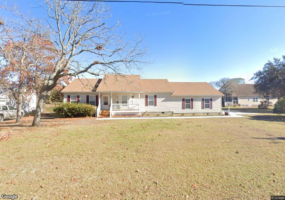
715 Summit Dr Southport, NC 28461
Estimated Value: $316,000 - $371,000
3
Beds
3
Baths
1,701
Sq Ft
$199/Sq Ft
Est. Value
About This Home
This home is located at 715 Summit Dr, Southport, NC 28461 and is currently estimated at $338,451, approximately $198 per square foot. 715 Summit Dr is a home located in Brunswick County with nearby schools including Bolivia Elementary School, South Brunswick Middle School, and South Brunswick High School.
Ownership History
Date
Name
Owned For
Owner Type
Purchase Details
Closed on
May 12, 2010
Sold by
Lombardi Frank A and Lombardi Margaret A
Bought by
Howard Donnie R and Howard Bonnie G
Current Estimated Value
Home Financials for this Owner
Home Financials are based on the most recent Mortgage that was taken out on this home.
Original Mortgage
$165,750
Outstanding Balance
$120,158
Interest Rate
5.02%
Mortgage Type
Purchase Money Mortgage
Estimated Equity
$218,293
Create a Home Valuation Report for This Property
The Home Valuation Report is an in-depth analysis detailing your home's value as well as a comparison with similar homes in the area
Home Values in the Area
Average Home Value in this Area
Purchase History
| Date | Buyer | Sale Price | Title Company |
|---|---|---|---|
| Howard Donnie R | $165,000 | None Available |
Source: Public Records
Mortgage History
| Date | Status | Borrower | Loan Amount |
|---|---|---|---|
| Open | Howard Donnie R | $165,750 |
Source: Public Records
Tax History
| Year | Tax Paid | Tax Assessment Tax Assessment Total Assessment is a certain percentage of the fair market value that is determined by local assessors to be the total taxable value of land and additions on the property. | Land | Improvement |
|---|---|---|---|---|
| 2025 | $2,008 | $339,830 | $74,250 | $265,580 |
| 2024 | $20 | $339,830 | $74,250 | $265,580 |
| 2023 | $1,653 | $339,830 | $74,250 | $265,580 |
| 2022 | $1,653 | $195,800 | $37,400 | $158,400 |
| 2021 | $1,639 | $195,800 | $37,400 | $158,400 |
| 2020 | $1,537 | $195,800 | $37,400 | $158,400 |
| 2019 | $1,537 | $44,640 | $37,400 | $7,240 |
| 2018 | $1,208 | $22,300 | $17,000 | $5,300 |
| 2017 | $1,178 | $22,300 | $17,000 | $5,300 |
| 2016 | $1,153 | $22,300 | $17,000 | $5,300 |
| 2015 | $1,153 | $151,510 | $17,000 | $134,510 |
| 2014 | $1,135 | $168,956 | $36,000 | $132,956 |
Source: Public Records
Map
Nearby Homes
- 1156 Twin Lakes Dr
- 1116 Twin Lakes Dr
- 1154 Twin Lakes Dr
- 840 Eden Dr
- 1268 S Shore Dr
- 1272 S Shore Dr
- 808 Wimberley Rd
- 1361 Forest Lake Rd
- 1081 Greenview Rd
- 940 Eden Dr
- 949 Eden Dr
- 1034 Bayside Rd
- 501 Eden Dr
- 76 Trevino Rd
- 949 Fifty Lakes Dr
- 530 Sioux Rd
- 1053 Springdale Rd
- 821 S Shore Dr
- 700 Fifty Lakes Dr
- 1045 Springdale Rd
- 715 Summit Rd
- 713 Summit Dr
- 1155 Summit Rd
- 716 Summit Rd
- 1159 Twin Lakes Dr
- 1159 Twin Lakes
- 1159 Twin Lakes
- 1157 Twin Lakes Dr
- 712 Summit Dr
- 1161 Twin Lakes Dr
- 710 Summit Dr
- 1109 Twin Lakes Dr
- 1109 Twin Lakes Dr
- 1163 Twin Lakes Dr
- Lot 14 Twin Lakes Dr
- Lot 13 Twin Lakes Dr
- Lot 4 Twin Lakes Dr
- 0 Twin Lakes Dr
- 0 Twin Lakes Dr
- 1138 Twin Lakes Dr
Your Personal Tour Guide
Ask me questions while you tour the home.