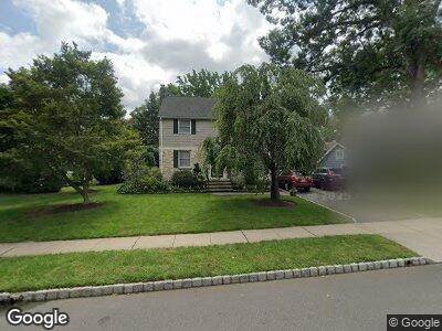
716 Kimball Ave Westfield, NJ 07090
Estimated Value: $972,000 - $1,325,000
--
Bed
--
Bath
2,271
Sq Ft
$499/Sq Ft
Est. Value
About This Home
This home is located at 716 Kimball Ave, Westfield, NJ 07090 and is currently estimated at $1,132,694, approximately $498 per square foot. 716 Kimball Ave is a home located in Union County with nearby schools including Wilson Elementary School, Roosevelt Intermediate School, and Westfield Senior High School.
Ownership History
Date
Name
Owned For
Owner Type
Purchase Details
Closed on
May 27, 1999
Sold by
Sullivan Kevin and Sullivan Anja
Bought by
Romano Christopher R and Romano Mary E
Current Estimated Value
Home Financials for this Owner
Home Financials are based on the most recent Mortgage that was taken out on this home.
Original Mortgage
$230,000
Interest Rate
6.85%
Mortgage Type
Purchase Money Mortgage
Purchase Details
Closed on
Jul 6, 1995
Sold by
Hoffmann Steven A and Hoffmann Lora F
Bought by
Sullivan Kevin and Sullivan Anja
Create a Home Valuation Report for This Property
The Home Valuation Report is an in-depth analysis detailing your home's value as well as a comparison with similar homes in the area
Home Values in the Area
Average Home Value in this Area
Purchase History
| Date | Buyer | Sale Price | Title Company |
|---|---|---|---|
| Romano Christopher R | $305,000 | -- | |
| Sullivan Kevin | $222,500 | -- |
Source: Public Records
Mortgage History
| Date | Status | Borrower | Loan Amount |
|---|---|---|---|
| Open | Romano Christopher R | $240,000 | |
| Closed | Romano Christopher R | $343,000 | |
| Closed | Romano Christopher R | $359,650 | |
| Closed | Romano Christopher R | $230,000 | |
| Previous Owner | Sullivan Kevin | $240,000 |
Source: Public Records
Tax History Compared to Growth
Tax History
| Year | Tax Paid | Tax Assessment Tax Assessment Total Assessment is a certain percentage of the fair market value that is determined by local assessors to be the total taxable value of land and additions on the property. | Land | Improvement |
|---|---|---|---|---|
| 2024 | $16,774 | $760,400 | $521,600 | $238,800 |
| 2023 | $16,774 | $760,400 | $521,600 | $238,800 |
| 2022 | $16,425 | $760,400 | $521,600 | $238,800 |
| 2021 | $16,447 | $760,400 | $521,600 | $238,800 |
| 2020 | $16,409 | $760,400 | $521,600 | $238,800 |
| 2019 | $16,349 | $760,400 | $521,600 | $238,800 |
| 2018 | $15,043 | $161,800 | $76,300 | $85,500 |
| 2017 | $14,960 | $161,800 | $76,300 | $85,500 |
| 2016 | $14,609 | $161,800 | $76,300 | $85,500 |
| 2015 | $14,318 | $161,800 | $76,300 | $85,500 |
| 2014 | $13,845 | $161,800 | $76,300 | $85,500 |
Source: Public Records
Map
Nearby Homes
- 303 Harrison Ave
- 512 Sherwood Pkwy
- 520 Raymond St
- 520 Mountain Ave
- 800 Franklin Ave
- 504 Mountain Ave
- 445 Topping Hill Rd
- 40 Canterbury Ln
- 123 Linden Ave
- 460 Topping Hill Rd
- 752 Belvidere Ave
- 521 Topping Hill Rd
- 569 Colonial Ave
- 591 Terrace Place
- 826 Wallberg Ave
- 534 Alden Ave
- 821 Grant Ave
- 816 E Broad St
- 18 Bennett Place
- 820 E Broad St
- 716 Kimball Ave
- 720 Kimball Ave
- 321 Baker Ave
- 334 N Chestnut St
- 336 N Chestnut St
- 328 N Chestnut St
- 715 Kimball Ave
- 324 N Chestnut St
- 721 Kimball Ave
- 402 N Chestnut St
- 315 Baker Ave
- 320 N Chestnut St
- 409 Baker Ave
- 410 N Chestnut St
- 311 Baker Ave
- 729 Kimball Ave
- 316 N Chestnut St
- 413 Baker Ave
- 312 N Chestnut St
- 412 N Chestnut St