Estimated Value: $228,424 - $271,000
3
Beds
2
Baths
1,710
Sq Ft
$149/Sq Ft
Est. Value
About This Home
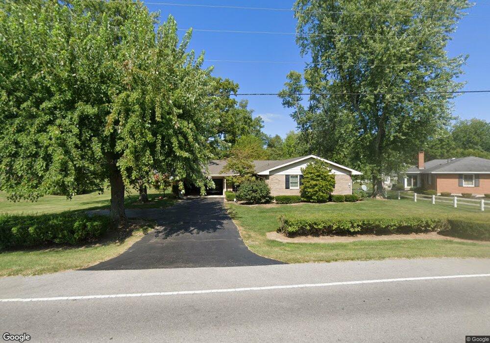
This home is located at 716 Us Route 35, Eaton, OH 45320 and is currently estimated at $255,356, approximately $149 per square foot. 716 Us Route 35 is a home located in Preble County with nearby schools including Hollingsworth East Elementary School, William Bruce Elementary School, and Eaton Middle School.
Ownership History
Date
Name
Owned For
Owner Type
Purchase Details
Closed on
Dec 22, 2008
Sold by
Herring John A and Herring Kathryn E
Bought by
Aukerman William J and Aukerman Rachael E
Current Estimated Value
Home Financials for this Owner
Home Financials are based on the most recent Mortgage that was taken out on this home.
Original Mortgage
$166,305
Outstanding Balance
$110,207
Interest Rate
6.19%
Mortgage Type
FHA
Estimated Equity
$145,149
Purchase Details
Closed on
Feb 29, 1988
Bought by
Aukerman William J and Aukerman Rachael E
Create a Home Valuation Report for This Property
The Home Valuation Report is an in-depth analysis detailing your home's value as well as a comparison with similar homes in the area
Home Values in the Area
Average Home Value in this Area
Purchase History
| Date | Buyer | Sale Price | Title Company |
|---|---|---|---|
| Aukerman William J | $168,500 | Partners Title Agency | |
| Aukerman William J | $84,500 | -- |
Source: Public Records
Mortgage History
| Date | Status | Borrower | Loan Amount |
|---|---|---|---|
| Open | Aukerman William J | $166,305 |
Source: Public Records
Tax History Compared to Growth
Tax History
| Year | Tax Paid | Tax Assessment Tax Assessment Total Assessment is a certain percentage of the fair market value that is determined by local assessors to be the total taxable value of land and additions on the property. | Land | Improvement |
|---|---|---|---|---|
| 2024 | $2,296 | $65,730 | $11,970 | $53,760 |
| 2023 | $2,296 | $65,730 | $11,970 | $53,760 |
| 2022 | $2,157 | $50,970 | $9,700 | $41,270 |
| 2021 | $2,266 | $50,970 | $9,700 | $41,270 |
| 2020 | $2,180 | $50,970 | $9,700 | $41,270 |
| 2019 | $1,969 | $45,510 | $8,650 | $36,860 |
| 2018 | $2,032 | $45,510 | $8,650 | $36,860 |
| 2017 | $1,925 | $45,510 | $8,650 | $36,860 |
| 2016 | $1,818 | $44,030 | $8,400 | $35,630 |
| 2014 | $1,847 | $44,030 | $8,400 | $35,630 |
| 2013 | $1,847 | $44,030 | $8,400 | $35,630 |
Source: Public Records
Map
Nearby Homes
- 115 Woodland Dr
- 308 Hubble St
- 331 W Chicago St
- 405 Walnut St
- 230 W Spring St
- 210 W Spring St
- 124 Deem St
- 111 W High St
- 233 N Barron St
- 919 N Barron St
- 115 E Decatur St
- 0-00 Washington Jackson Rd
- 612 N Cherry St
- 105 Leatherman Place
- 125 E Decatur St
- 130 E Chicago St
- 219 E High St
- 414 N Maple St
- 1008 N Maple St
- 401 Romadoor Ave Unit 511 (BLDG 12)
- 716 Richmond Pike
- 111 Woodland Dr
- 724 U S 35
- 724 Richmond Pike
- 724 Us Route 35
- 123 Woodland Dr
- 127 Woodland Dr
- 612 Us Route 35
- 119 Woodland Dr
- 112 Woodland Dr
- 325 Lutheran Dr
- 144 Woodland Dr
- 140 Woodland Dr
- 116 Woodland Dr
- 148 Woodland Dr
- 160 Woodland Dr
- 136 Woodland Dr
- 321 Lutheran Dr
- 152 Woodland Dr
- 320 Lutheran Dr