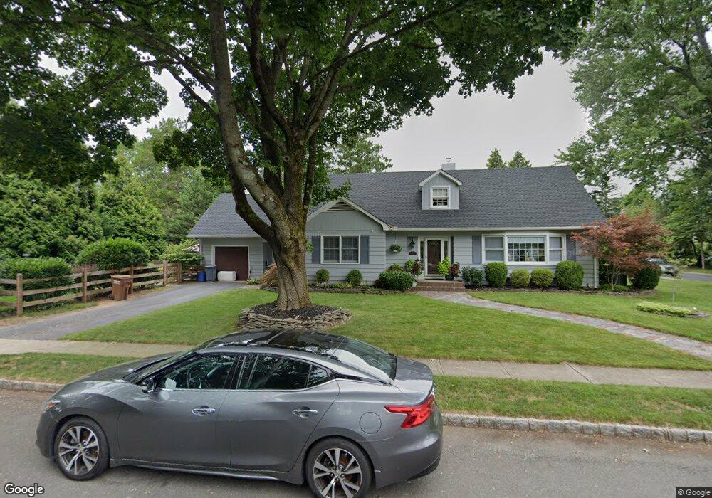
717 Hawthorne Ave Bound Brook, NJ 08805
Estimated Value: $605,000 - $677,000
--
Bed
--
Bath
2,704
Sq Ft
$236/Sq Ft
Est. Value
About This Home
This home is located at 717 Hawthorne Ave, Bound Brook, NJ 08805 and is currently estimated at $638,536, approximately $236 per square foot. 717 Hawthorne Ave is a home located in Somerset County with nearby schools including Adamsville Primary School, Bridgewater-Raritan Middle School, and Hillside Intermediate School.
Ownership History
Date
Name
Owned For
Owner Type
Purchase Details
Closed on
Oct 1, 2002
Sold by
Garry Lori
Bought by
Baker Jeff and Baker Kendra
Current Estimated Value
Home Financials for this Owner
Home Financials are based on the most recent Mortgage that was taken out on this home.
Original Mortgage
$293,600
Outstanding Balance
$123,449
Interest Rate
6.2%
Estimated Equity
$515,087
Create a Home Valuation Report for This Property
The Home Valuation Report is an in-depth analysis detailing your home's value as well as a comparison with similar homes in the area
Home Values in the Area
Average Home Value in this Area
Purchase History
| Date | Buyer | Sale Price | Title Company |
|---|---|---|---|
| Baker Jeff | $367,000 | -- |
Source: Public Records
Mortgage History
| Date | Status | Borrower | Loan Amount |
|---|---|---|---|
| Open | Baker Jeff | $293,600 |
Source: Public Records
Tax History Compared to Growth
Tax History
| Year | Tax Paid | Tax Assessment Tax Assessment Total Assessment is a certain percentage of the fair market value that is determined by local assessors to be the total taxable value of land and additions on the property. | Land | Improvement |
|---|---|---|---|---|
| 2025 | $9,490 | $502,200 | $212,400 | $289,800 |
| 2024 | $9,490 | $481,500 | $212,400 | $269,100 |
| 2023 | $8,923 | $444,600 | $212,400 | $232,200 |
| 2022 | $8,505 | $407,700 | $207,400 | $200,300 |
| 2021 | $8,190 | $396,200 | $207,400 | $188,800 |
| 2020 | $8,189 | $384,800 | $207,400 | $177,400 |
| 2019 | $8,190 | $381,100 | $207,400 | $173,700 |
| 2018 | $7,783 | $363,000 | $207,400 | $155,600 |
| 2017 | $7,560 | $352,300 | $207,400 | $144,900 |
| 2016 | $7,123 | $336,800 | $192,400 | $144,400 |
| 2015 | $7,060 | $334,100 | $192,400 | $141,700 |
| 2014 | $7,031 | $327,800 | $192,400 | $135,400 |
Source: Public Records
Map
Nearby Homes
- 811 Mountain Ave
- 650 Central Ave
- 807 Watchung Rd
- 180 Farm Ln
- 14 E Maple Ave
- 745 Schoolhouse Ln
- 563 Winsor St
- 112 E Union Ave
- 205 Ashland Rd
- 112-114 E Union Ave
- 520 Winsor St
- 311 Ashland Rd
- 320 Church St
- 363 Grant Ave
- 112 East St
- 1891 Middlebrook Rd
- 116 Greene Ave
- 1820 Woodland Terrace
- 102 W Franklin St
- 231 Fairview Ave
- 242 Willow St
- 707 Hawthorne Ave
- 236 Willow St
- 714 Hawthorne Ave
- 716 Hawthorne Ave
- 699 Hawthorne Ave
- 720 Hawthorne Ave
- 727 Hawthorne Ave
- 706 Hawthorne Ave
- 230 Willow St
- 718 Park Ave
- 724 Hawthorne Ave
- 685 Hawthorne Ave
- 698 Hawthorne Ave
- 729 Hawthorne Ave
- 226 Willow St
- 720 Park Ave
- 730 Hawthorne Ave
- 731 Hawthorne Ave
- 730 Park Ave