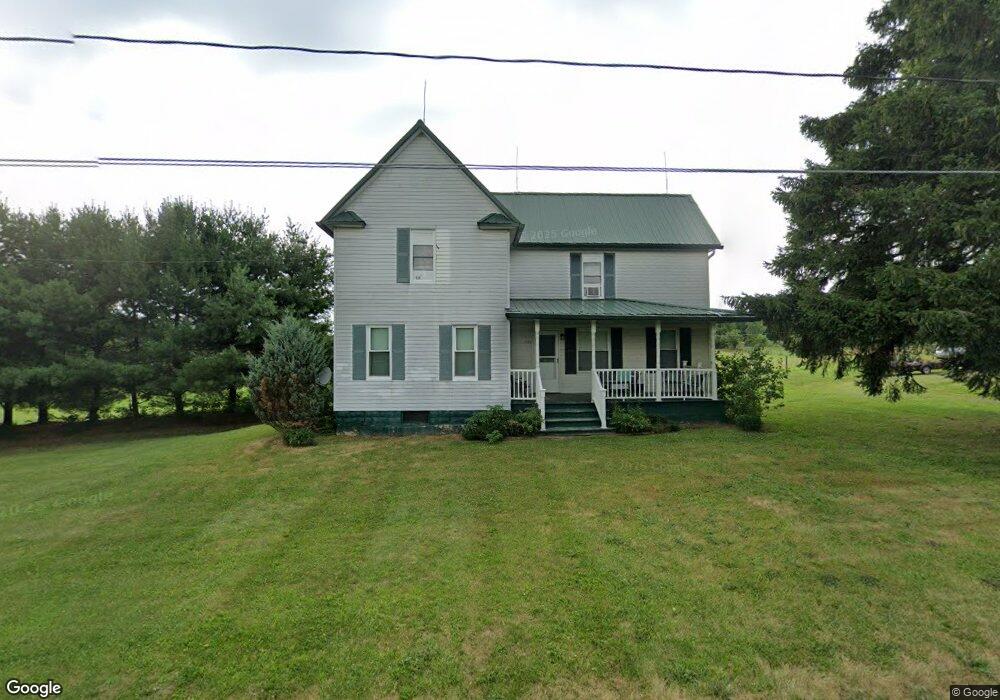
7171 Kennard Rd Seville, OH 44273
Estimated Value: $283,092 - $418,000
3
Beds
1
Bath
1,640
Sq Ft
$204/Sq Ft
Est. Value
About This Home
This home is located at 7171 Kennard Rd, Seville, OH 44273 and is currently estimated at $335,273, approximately $204 per square foot. 7171 Kennard Rd is a home located in Medina County with nearby schools including Cloverleaf Elementary School, Cloverleaf Middle School, and Cloverleaf High School.
Ownership History
Date
Name
Owned For
Owner Type
Purchase Details
Closed on
Apr 25, 2017
Sold by
Syme Robert P and Syme Sally S
Bought by
Carragher Julie Syme and Carragher Frank
Current Estimated Value
Purchase Details
Closed on
Feb 8, 2007
Sold by
Anderson Donald M B
Bought by
Syme Robert P
Purchase Details
Closed on
Mar 24, 2006
Sold by
Kelland Laurel C
Bought by
Anderson Donald M and Anderson B
Purchase Details
Closed on
Feb 8, 2002
Sold by
Mills Richard B
Bought by
Mills Richard B and Kelland Laurel C
Create a Home Valuation Report for This Property
The Home Valuation Report is an in-depth analysis detailing your home's value as well as a comparison with similar homes in the area
Home Values in the Area
Average Home Value in this Area
Purchase History
| Date | Buyer | Sale Price | Title Company |
|---|---|---|---|
| Carragher Julie Syme | $150,000 | None Available | |
| Syme Robert P | $154,000 | -- | |
| Anderson Donald M | $154,000 | -- | |
| Mills Richard B | -- | Ltic |
Source: Public Records
Tax History Compared to Growth
Tax History
| Year | Tax Paid | Tax Assessment Tax Assessment Total Assessment is a certain percentage of the fair market value that is determined by local assessors to be the total taxable value of land and additions on the property. | Land | Improvement |
|---|---|---|---|---|
| 2024 | $2,434 | $64,300 | $33,190 | $31,110 |
| 2023 | $2,434 | $64,300 | $33,190 | $31,110 |
| 2022 | $2,505 | $64,300 | $33,190 | $31,110 |
| 2021 | $2,111 | $49,090 | $25,340 | $23,750 |
| 2020 | $2,150 | $49,090 | $25,340 | $23,750 |
| 2019 | $2,163 | $49,090 | $25,340 | $23,750 |
| 2018 | $1,645 | $35,910 | $20,800 | $15,110 |
| 2017 | $1,580 | $35,910 | $20,800 | $15,110 |
| 2016 | $1,602 | $35,910 | $20,800 | $15,110 |
| 2015 | $1,558 | $33,890 | $19,630 | $14,260 |
| 2014 | $1,551 | $33,890 | $19,630 | $14,260 |
| 2013 | $1,434 | $33,890 | $19,630 | $14,260 |
Source: Public Records
Map
Nearby Homes
- 8525 Broxton Ct
- 7595 Kings Creek Dr
- 8849 Concord Dr
- 6895 Grant Dr
- 7101 Greenwich Rd
- 7009 Greenwich Rd
- Lot #3 Ballash Rd
- 6200 Buffham Rd
- 537 Lee Lore Dr
- 304 Redfern Rd
- V/L Brookshore
- 130 Clovercliff Dr
- 7390 Chestnut St
- 0 Greenwich Rd Unit 5170888
- Lot #4 Chippewa Rd
- Lot #6 Chippewa Rd
- 0 Walnut Dr
- 7762 Chesterfield Dr
- 9250 Daniels Rd
- 5829 Heatherhedge Dr
- 7145 Kennard Rd
- 7241 Kennard Rd
- 7099 Kennard Rd
- 7255 Kennard Rd
- 7087 Kennard Rd
- 7087 Kennard Rd
- 7271 Kennard Rd
- 7073 Kennard Rd
- 7285 Kennard Rd
- 7057 Kennard Rd
- 7033 Kennard Rd
- 7379 Kennard Rd
- 6970 Kennard Rd
- 8146 Westfield Rd
- V/L Kennard Rd
- 7400 Kennard Rd
- 8050 Westfield Rd
- 7418 Kennard Rd
- 32 Lake
- 8076 Westfield Rd