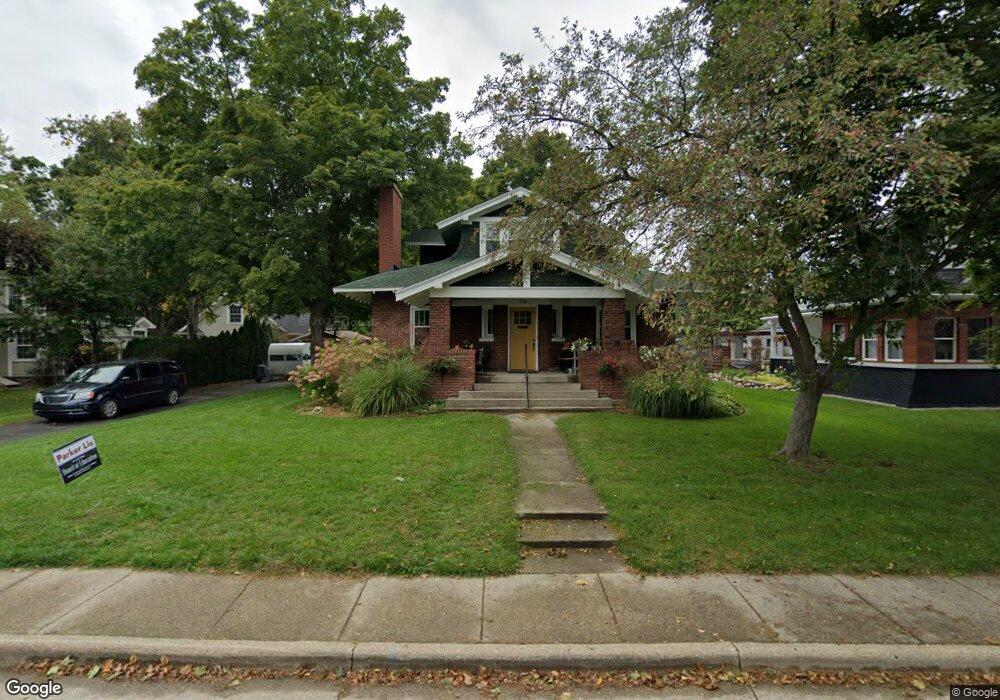
718 Riverside Dr Lowell, MI 49331
Estimated Value: $332,000 - $463,185
3
Beds
2
Baths
3,250
Sq Ft
$132/Sq Ft
Est. Value
About This Home
This home is located at 718 Riverside Dr, Lowell, MI 49331 and is currently estimated at $430,046, approximately $132 per square foot. 718 Riverside Dr is a home located in Kent County with nearby schools including Bushnell Elementary School, Cherry Creek Elementary School, and Lowell Middle School.
Ownership History
Date
Name
Owned For
Owner Type
Purchase Details
Closed on
Sep 18, 2020
Sold by
Bredin Eric Sherwood and Bredin Linday Fay
Bought by
Bredin Eric Sherwood and Bredin Lidnsay Fay
Current Estimated Value
Purchase Details
Closed on
Jul 12, 2007
Sold by
Ellsworth Yvette L
Bought by
Bredin Lindsay F and Bredin Eric S
Home Financials for this Owner
Home Financials are based on the most recent Mortgage that was taken out on this home.
Original Mortgage
$310,410
Interest Rate
6.54%
Mortgage Type
Purchase Money Mortgage
Purchase Details
Closed on
Aug 17, 2005
Sold by
Ellsworth Yvette L and Defler Yvette
Bought by
Ellsworth Yvette L
Purchase Details
Closed on
Jul 21, 2000
Bought by
Bredin Defler and Bredin Lindsay F
Purchase Details
Closed on
May 9, 1997
Bought by
Bredin Maioho and Bredin Lindsay F
Purchase Details
Closed on
Aug 2, 1991
Bought by
Bredin Brown and Bredin Lindsay F
Create a Home Valuation Report for This Property
The Home Valuation Report is an in-depth analysis detailing your home's value as well as a comparison with similar homes in the area
Home Values in the Area
Average Home Value in this Area
Purchase History
| Date | Buyer | Sale Price | Title Company |
|---|---|---|---|
| Bredin Eric Sherwood | -- | None Available | |
| Bredin Eric Sherwood | -- | Napa Land Title | |
| Bredin Lindsay F | $205,000 | Chicago Title | |
| Ellsworth Yvette L | -- | Fatic | |
| Bredin Defler | $169,900 | -- | |
| Bredin Maioho | $125,000 | -- | |
| Bredin Brown | $90,000 | -- |
Source: Public Records
Mortgage History
| Date | Status | Borrower | Loan Amount |
|---|---|---|---|
| Previous Owner | Bredin Lindsay F | $310,410 |
Source: Public Records
Tax History
| Year | Tax Paid | Tax Assessment Tax Assessment Total Assessment is a certain percentage of the fair market value that is determined by local assessors to be the total taxable value of land and additions on the property. | Land | Improvement |
|---|---|---|---|---|
| 2025 | $4,989 | $216,700 | $0 | $0 |
| 2024 | $6,421 | $214,500 | $0 | $0 |
| 2023 | $4,765 | $197,100 | $0 | $0 |
| 2022 | $6,030 | $176,400 | $0 | $0 |
| 2021 | $5,885 | $156,000 | $0 | $0 |
| 2020 | $3,511 | $123,000 | $0 | $0 |
| 2019 | $4,123 | $120,500 | $0 | $0 |
| 2018 | $4,035 | $115,500 | $0 | $0 |
| 2017 | $3,934 | $106,500 | $0 | $0 |
| 2016 | $3,825 | $102,500 | $0 | $0 |
| 2015 | -- | $102,500 | $0 | $0 |
| 2013 | -- | $83,400 | $0 | $0 |
Source: Public Records
Map
Nearby Homes
- 517 Elm St SE
- 622 N Washington St
- 418 Elm St SE
- 607 N Washington St
- 913 N Monroe St
- 723 N Washington St
- 118 N Hudson St SE
- 705 N Jefferson St
- 829 N Jefferson St
- 1080 N Washington St SE
- 517 Front St
- 1040 N Washington Rd
- 222 S Division St
- 780 Bowes Rd
- 926 E Main St
- 913 Clark St Unit 7
- 1751 Gee Dr SE
- 320 Roberta Jayne Dr
- 1800 W Main St Unit 105
- 1800 W Main St Unit 50
- 724 Riverside Dr
- 706 Riverside Dr
- 804 Riverside Dr
- 805 N Hudson St SE
- 624 Riverside Dr
- 805 N Hudson St
- 810 Riverside Dr
- 722 N Hudson St
- 722 N Hudson St SE
- 724 N Hudson St SE
- 704 N Hudson St
- 724 N Hudson St
- 815 N Hudson St
- 618 Riverside Dr
- 806 N Hudson St
- 904 Riverside Dr
- 624 N Hudson St
- 903 N Hudson St SE
- 723 Lincoln Lake
- 725 Lincoln Lake
Your Personal Tour Guide
Ask me questions while you tour the home.