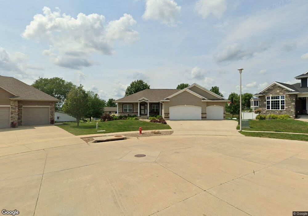
719 Adams Ct Center Point, IA 52213
Estimated Value: $447,000 - $505,000
5
Beds
3
Baths
3,039
Sq Ft
$156/Sq Ft
Est. Value
About This Home
This home is located at 719 Adams Ct, Center Point, IA 52213 and is currently estimated at $473,747, approximately $155 per square foot. 719 Adams Ct is a home located in Linn County with nearby schools including Center Point-Urbana Primary School, Center Point-Urbana Intermediate School, and Center Point-Urbana Middle School.
Ownership History
Date
Name
Owned For
Owner Type
Purchase Details
Closed on
Nov 14, 2019
Sold by
Wilkerson Doug and Wilkerson Carrie
Bought by
Leedom David and Leedom Lorinda
Current Estimated Value
Home Financials for this Owner
Home Financials are based on the most recent Mortgage that was taken out on this home.
Original Mortgage
$353,280
Outstanding Balance
$311,104
Interest Rate
3.65%
Mortgage Type
VA
Estimated Equity
$162,643
Purchase Details
Closed on
Jun 16, 2009
Sold by
Junge Labs Development Llc
Bought by
Wilkerson Doug and Wilkerson Carrie
Home Financials for this Owner
Home Financials are based on the most recent Mortgage that was taken out on this home.
Original Mortgage
$205,300
Interest Rate
4.92%
Mortgage Type
Construction
Create a Home Valuation Report for This Property
The Home Valuation Report is an in-depth analysis detailing your home's value as well as a comparison with similar homes in the area
Home Values in the Area
Average Home Value in this Area
Purchase History
| Date | Buyer | Sale Price | Title Company |
|---|---|---|---|
| Leedom David | $350,000 | None Available | |
| Wilkerson Doug | $46,000 | None Available |
Source: Public Records
Mortgage History
| Date | Status | Borrower | Loan Amount |
|---|---|---|---|
| Open | Leedom David | $353,280 | |
| Previous Owner | Wilkerson Doug | $205,300 |
Source: Public Records
Tax History Compared to Growth
Tax History
| Year | Tax Paid | Tax Assessment Tax Assessment Total Assessment is a certain percentage of the fair market value that is determined by local assessors to be the total taxable value of land and additions on the property. | Land | Improvement |
|---|---|---|---|---|
| 2025 | $8,138 | $485,200 | $47,400 | $437,800 |
| 2024 | $7,646 | $458,400 | $47,400 | $411,000 |
| 2023 | $7,646 | $458,400 | $47,400 | $411,000 |
| 2022 | $7,496 | $364,000 | $47,400 | $316,600 |
| 2021 | $7,074 | $357,700 | $45,000 | $312,700 |
| 2020 | $7,074 | $321,100 | $45,000 | $276,100 |
| 2019 | $5,958 | $278,700 | $45,000 | $233,700 |
| 2018 | $5,820 | $278,700 | $45,000 | $233,700 |
| 2017 | $6,186 | $287,100 | $45,000 | $242,100 |
| 2016 | $6,153 | $287,100 | $45,000 | $242,100 |
| 2015 | $6,159 | $287,100 | $45,000 | $242,100 |
| 2014 | $5,972 | $282,800 | $45,000 | $237,800 |
| 2013 | $5,838 | $282,800 | $45,000 | $237,800 |
Source: Public Records
Map
Nearby Homes
- 829 Main St S
- 523 E Terrace Dr
- 529 Jefferson Ct
- 318 Crestview Dr
- 0 Palo Rd
- 31 Acres N Center Point Rd
- 115 Main St
- 0 Grain Ln
- 4299 Lewis Access Rd
- 0 Iowa St
- 809 Iowa St
- 507 Maplewood Dr
- 601 Maplewood Dr
- 717 Pointer Cir
- 718 Pointer Cir
- 316 E Washington St
- 702 Central Ave
- 120 Green St
- 132 Green St
- 508 Vine St
- 713 Adams Ct
- 712 E Terrace Dr
- 706 E Terrace Dr
- 724 Adams Ct
- 718 E Terrace Dr
- 624 E Terrace Dr
- 624 Lincoln Ct
- 730 Adams Ct
- LOT 2 Adams Ct
- 724 E Terrace Dr
- 707 Adams Ct
- 618 E Terrace Dr
- 617 Main St S
- 736 Adams Ct
- 806 E Terrace Dr
- 411 Valley Dr
- 817 Main St S
- 817 Main St S Unit Lot 1
- 0 Lot 11 Lincoln Ct Unit 1505082
- Lot 8 Lincoln Ct