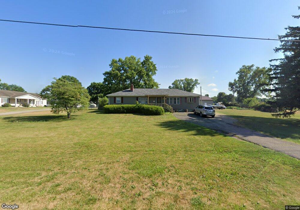
719 Anderson Station Rd Chillicothe, OH 45601
Estimated Value: $198,318 - $322,000
3
Beds
1
Bath
1,400
Sq Ft
$195/Sq Ft
Est. Value
About This Home
This home is located at 719 Anderson Station Rd, Chillicothe, OH 45601 and is currently estimated at $272,330, approximately $194 per square foot. 719 Anderson Station Rd is a home located in Ross County with nearby schools including Unioto Elementary School, Unioto Middle School, and Unioto High School.
Ownership History
Date
Name
Owned For
Owner Type
Purchase Details
Closed on
Dec 10, 2013
Sold by
Carroll Janelle and Carroll Lemuel
Bought by
Knox James
Current Estimated Value
Home Financials for this Owner
Home Financials are based on the most recent Mortgage that was taken out on this home.
Original Mortgage
$128,571
Outstanding Balance
$96,739
Interest Rate
4.38%
Mortgage Type
New Conventional
Estimated Equity
$175,591
Create a Home Valuation Report for This Property
The Home Valuation Report is an in-depth analysis detailing your home's value as well as a comparison with similar homes in the area
Home Values in the Area
Average Home Value in this Area
Purchase History
| Date | Buyer | Sale Price | Title Company |
|---|---|---|---|
| Knox James | $126,000 | Title First Agency Inc |
Source: Public Records
Mortgage History
| Date | Status | Borrower | Loan Amount |
|---|---|---|---|
| Open | Knox James | $128,571 |
Source: Public Records
Tax History Compared to Growth
Tax History
| Year | Tax Paid | Tax Assessment Tax Assessment Total Assessment is a certain percentage of the fair market value that is determined by local assessors to be the total taxable value of land and additions on the property. | Land | Improvement |
|---|---|---|---|---|
| 2024 | $996 | $28,860 | $4,410 | $24,450 |
| 2023 | $996 | $28,860 | $4,410 | $24,450 |
| 2022 | $1,017 | $28,860 | $4,410 | $24,450 |
| 2021 | $897 | $23,800 | $3,680 | $20,120 |
| 2020 | $902 | $23,800 | $3,680 | $20,120 |
| 2019 | $902 | $23,800 | $3,680 | $20,120 |
| 2018 | $903 | $23,370 | $2,940 | $20,430 |
| 2017 | $905 | $23,370 | $2,940 | $20,430 |
| 2016 | $882 | $23,370 | $2,940 | $20,430 |
| 2015 | $867 | $22,780 | $2,940 | $19,840 |
| 2014 | $846 | $22,780 | $2,940 | $19,840 |
| 2013 | $850 | $22,780 | $2,940 | $19,840 |
Source: Public Records
Map
Nearby Homes
- 313 Goodale Dr
- 365 Golfview Dr
- 54 Moccasin Dr
- 559 Golfview Dr
- 102 Franklin Cir
- 11303 County Road 550
- 18 Sarah Ct
- 2083 Anderson Station Rd
- 435 Mount Carmel Rd
- 10217 County Road 550
- 12690 Pleasant Valley Rd
- 1036 Clinton Rd
- 320 Summerhill Dr
- 420 Steiner Rd
- 13223 Pleasant Valley Rd
- 265 Brookside Dr
- 2153 Egypt Pike
- 2719 Sulphur Lick Rd
- 88 Fruit Hill Dr
- 45 Custer Dr
- 747 Anderson Station Rd
- 714 Anderson Station Rd
- 734 Anderson Station Rd
- 52 Goodale Dr
- 683 Anderson Station Rd
- 752 Anderson Station Rd
- 696 Anderson Station Rd
- 348 Goodale Dr
- 53 Goodale Dr
- 768 Anderson Station Rd
- 668 Anderson Station Rd
- 76 Goodale Dr
- 787 Anderson Station Rd
- 334 Goodale Dr
- 71 Goodale Dr
- 361 Goodale Dr
- 782 Anderson Station Rd
- 658 Anderson Station Rd
- 658 Anderson Station Rd
- 663 Anderson Station Rd