
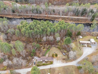
72 Ayers Rd Newport, NH 03773
Estimated payment $2,729/month
Highlights
- Hot Property
- 4.3 Acre Lot
- Contemporary Architecture
- River Front
- Deck
- Wetlands on Lot
About This Home
Discover the potential at 72 Ayers Road with over 700 feet of frontage on the beautiful Sugar River, this property offers a rare opportunity to enjoy the sights and sounds of nature right in your backyard. The Rail Trail runs on the other side of the river, perfect for biking, walking, and snowmobiling in winter or ATV adventures in summer.
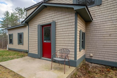
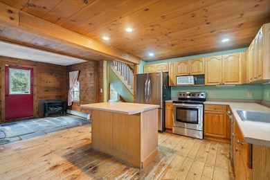
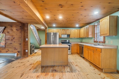
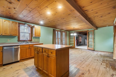
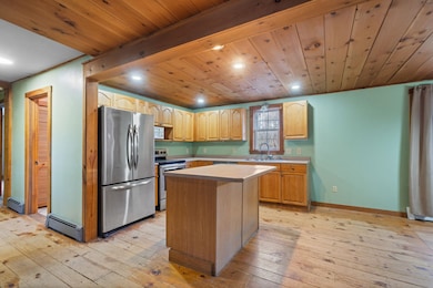
A balcony, decks and covered porch invite you to enjoy your 4.3 acres of outdoor space. Partial fenced in backyard and garden beds. Walk inside from your covered porch and you will discover pine floors( that need a bit of love) throughout. Great room with its vaulted ceiling has that cozy cabin feel but spacious. Open kitchen/dining area with oak cabinets and kitchen island has space for everyone to gather for meals. Flexible floor plan makes it possible for single floor living. The home is ready for your personal touch—a little sweat equity will go a long way in bringing back its original charm and value. Set on a peaceful country road just minutes from downtown Newport and less than 10 minutes to Claremont, this property combines privacy, recreation, and convenience.
Whether you’re looking for a year-round home, a getaway spot, or an investment project, this location delivers the best of rural New Hampshire living.
Listing Agent
EXP Realty Brokerage Phone: 603-325-5909 License #069048 Listed on: 11/08/2025

Home Details
Home Type
- Single Family
Est. Annual Taxes
- $7,509
Year Built
- Built in 1930
Lot Details
- 4.3 Acre Lot
- River Front
- Wooded Lot
- Garden
- Property is zoned R40 R
Parking
- Gravel Driveway
Home Design
- Contemporary Architecture
- Concrete Foundation
- Stone Foundation
- Metal Roof
- Shake Siding
Interior Spaces
- Property has 2 Levels
- Woodwork
- Vaulted Ceiling
- Natural Light
- Great Room
- Combination Kitchen and Dining Room
- Washer
Kitchen
- Dishwasher
- Kitchen Island
Flooring
- Softwood
- Carpet
- Vinyl
Bedrooms and Bathrooms
- 2 Bedrooms
- En-Suite Bathroom
Basement
- Basement Fills Entire Space Under The House
- Walk-Up Access
Outdoor Features
- Wetlands on Lot
- Deck
- Shed
Schools
- Richards Elementary School
- Newport Middle And High School
- Newport Middle High School
Utilities
- Baseboard Heating
- Spring water is a source of water for the property
- Shared Water Source
- Dug Well
- Cable TV Available
Community Details
- Trails
Listing and Financial Details
- Tax Lot 49
- Assessor Parcel Number 234
Map
Home Values in the Area
Average Home Value in this Area
Tax History
| Year | Tax Paid | Tax Assessment Tax Assessment Total Assessment is a certain percentage of the fair market value that is determined by local assessors to be the total taxable value of land and additions on the property. | Land | Improvement |
|---|---|---|---|---|
| 2024 | $7,509 | $308,900 | $107,400 | $201,500 |
| 2023 | $7,284 | $308,900 | $107,400 | $201,500 |
| 2022 | $6,456 | $308,900 | $107,400 | $201,500 |
| 2021 | $5,323 | $161,300 | $56,000 | $105,300 |
| 2020 | $5,697 | $172,100 | $56,000 | $116,100 |
| 2019 | $5,598 | $172,100 | $56,000 | $116,100 |
| 2018 | $5,232 | $172,100 | $56,000 | $116,100 |
| 2017 | $5,170 | $172,100 | $56,000 | $116,100 |
| 2016 | $5,036 | $175,300 | $52,000 | $123,300 |
| 2015 | $5,128 | $175,300 | $52,000 | $123,300 |
| 2014 | $5,546 | $175,300 | $52,000 | $123,300 |
| 2013 | $5,257 | $175,300 | $52,000 | $123,300 |
Property History
| Date | Event | Price | List to Sale | Price per Sq Ft |
|---|---|---|---|---|
| 11/08/2025 11/08/25 | For Sale | $399,000 | -- | $205 / Sq Ft |
Purchase History
| Date | Type | Sale Price | Title Company |
|---|---|---|---|
| Warranty Deed | $135,000 | -- |
Mortgage History
| Date | Status | Loan Amount | Loan Type |
|---|---|---|---|
| Open | $108,000 | No Value Available |
Source: PrimeMLS
MLS Number: 5068984
APN: NWPT-000234-049000
Disclaimer: Certain information contained herein is derived from information provided by parties other than Homes.com. All information provided is deemed reliable, but is not guaranteed to be accurate and should be independently verified.
![]() Copyright 2025 PrimeMLS, Inc. All rights reserved. This information is deemed reliable, but not guaranteed. The data relating to real estate displayed on this display comes in part from the IDX Program of PrimeMLS. The information being provided is for consumers’ personal, non-commercial use and may not be used for any purpose other than to identify prospective properties consumers may be interested in purchasing.
Copyright 2025 PrimeMLS, Inc. All rights reserved. This information is deemed reliable, but not guaranteed. The data relating to real estate displayed on this display comes in part from the IDX Program of PrimeMLS. The information being provided is for consumers’ personal, non-commercial use and may not be used for any purpose other than to identify prospective properties consumers may be interested in purchasing.
- 680-2 John Stark Hwy
- 430 John Stark Hwy
- 12 Brown Rd
- 163 Elm St
- 23 Fletcher Rd
- 146 Elm St
- 12 4th St
- 2 Croydon Brook Rd
- 13 Fairbanks Rd
- 11 Putnam Rd
- 39 Myrtle St
- 29-31 Myrtle St
- 140 and 146 N Main St
- 151 Cheney St
- 37 Park St
- 8 Prospect St
- 38 River St
- 300 E Green Mountain Rd
- 150 S Main St
- 214 S Main St
- 40 Unity Rd
- 17 Sullivan St
- 169 Sunapee St
- 264 Chestnut St
- 27 Route 103
- 42 Chestnut St Unit 2
- 8 Spofford St Unit 1
- 2 Winter St
- 115 North St
- 1 Pleasant St Unit 301
- 1 Pleasant St Unit 217
- 57 Pleasant St
- 5 School St Unit Studio Apt 11
- 109 Pleasant St Unit 3rd Floor
- 109 Pleasant St Unit 203
- 109 Pleasant St Unit 202
- 109 Pleasant St Unit 201
- 109 Pleasant St Unit Multiple
- 30 Sullivan St Unit 5
- 10 Spruce Ave Unit 2