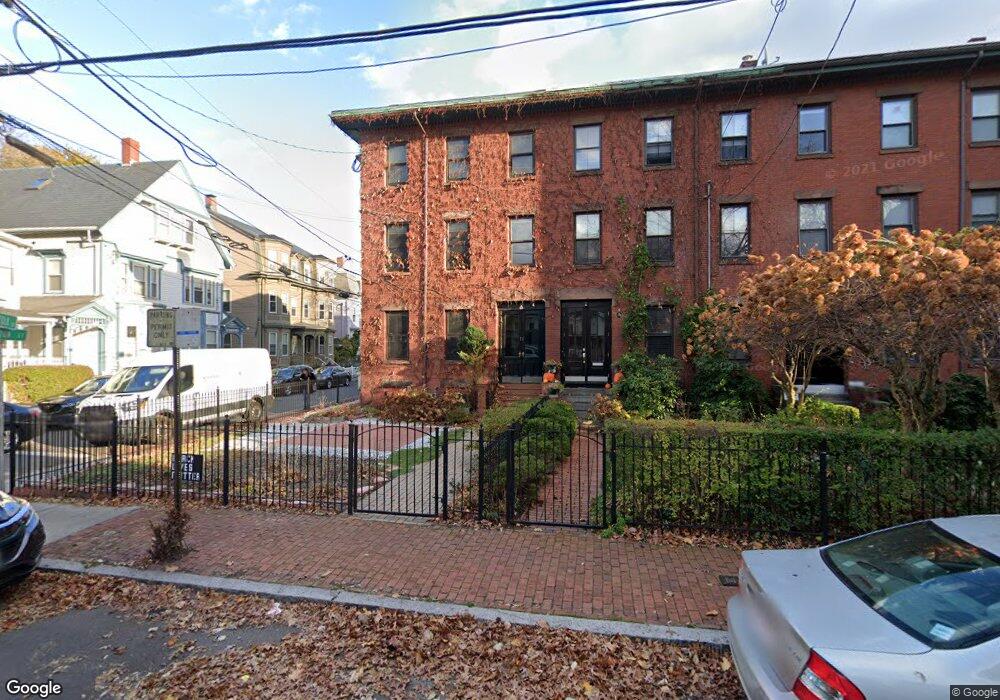
72 Norfolk St Cambridge, MA 02139
The Port NeighborhoodEstimated Value: $1,694,000 - $2,620,000
4
Beds
2
Baths
2,398
Sq Ft
$923/Sq Ft
Est. Value
About This Home
This home is located at 72 Norfolk St, Cambridge, MA 02139 and is currently estimated at $2,212,830, approximately $922 per square foot. 72 Norfolk St is a home located in Middlesex County with nearby schools including Prospect Hill Academy Charter School and Community Charter School of Cambridge.
Ownership History
Date
Name
Owned For
Owner Type
Purchase Details
Closed on
Jul 13, 2016
Sold by
Vu Sonny X and Xuan-Vu Sonny
Bought by
Caribou Llc
Current Estimated Value
Purchase Details
Closed on
May 12, 2008
Sold by
Duane Despina H
Bought by
Vu Sonny X
Home Financials for this Owner
Home Financials are based on the most recent Mortgage that was taken out on this home.
Original Mortgage
$417,000
Interest Rate
5.93%
Mortgage Type
Purchase Money Mortgage
Create a Home Valuation Report for This Property
The Home Valuation Report is an in-depth analysis detailing your home's value as well as a comparison with similar homes in the area
Home Values in the Area
Average Home Value in this Area
Purchase History
| Date | Buyer | Sale Price | Title Company |
|---|---|---|---|
| Caribou Llc | -- | -- | |
| Vu Sonny X | -- | -- | |
| Vu Sonny X | $715,000 | -- |
Source: Public Records
Mortgage History
| Date | Status | Borrower | Loan Amount |
|---|---|---|---|
| Previous Owner | Vu Sonny X | $417,000 |
Source: Public Records
Tax History
| Year | Tax Paid | Tax Assessment Tax Assessment Total Assessment is a certain percentage of the fair market value that is determined by local assessors to be the total taxable value of land and additions on the property. | Land | Improvement |
|---|---|---|---|---|
| 2025 | $12,723 | $2,003,600 | $760,100 | $1,243,500 |
| 2024 | $11,012 | $1,860,100 | $799,300 | $1,060,800 |
| 2023 | $11,023 | $1,881,100 | $812,700 | $1,068,400 |
| 2022 | $10,247 | $1,730,900 | $808,600 | $922,300 |
| 2021 | $9,540 | $1,630,800 | $793,000 | $837,800 |
| 2020 | $9,282 | $1,614,200 | $791,900 | $822,300 |
| 2019 | $8,579 | $1,444,300 | $695,000 | $749,300 |
| 2018 | $8,315 | $1,322,000 | $598,100 | $723,900 |
| 2017 | $7,922 | $1,220,700 | $534,600 | $686,100 |
| 2016 | $7,555 | $1,080,900 | $447,700 | $633,200 |
| 2015 | $7,334 | $937,900 | $374,200 | $563,700 |
| 2014 | $7,178 | $856,600 | $300,700 | $555,900 |
Source: Public Records
Map
Nearby Homes
- 7 Marvin Place
- 310 Broadway Unit 310
- 280 Green St
- 149A Bishop Allen Unit A
- 62 Pearl St
- 129 Auburn St
- 127 Auburn St
- 280 Harvard St Unit 2D
- 51 Market St Unit 2
- 196 Prospect St
- 199 Prospect St Unit 1
- 300 Franklin St Unit 5
- 300 Franklin St Unit 1
- 114 Elm St
- 172-174 Auburn St Unit 3
- 22 Magazine
- 104-106 Auburn St
- 31 Tremont St
- 67 Inman St
- 6 Watson St Unit 1
- 72 Norfolk St Unit 7
- 72 Norfolk St Unit 8
- 72 Norfolk St Unit 2
- 72 Norfolk St
- 72 Norfolk St Unit 1
- 70 Norfolk St
- 70 Norfolk St Unit 8
- 68 Norfolk St
- 400 Washington St
- 400 Washington St Unit PH3
- 2 Norfolk St Unit 2
- 409 Washington St
- 407 Washington St
- 413 Washington St
- 413 Washington St
- 413 Washington St Unit 3
- 413 Washington St Unit 2
- 413 Washington St Unit 1
- 401 Washington St Unit 6
- 401 Washington St Unit 5
Your Personal Tour Guide
Ask me questions while you tour the home.