Estimated Value: $142,000 - $208,000
Studio
1
Bath
1,448
Sq Ft
$123/Sq Ft
Est. Value
About This Home
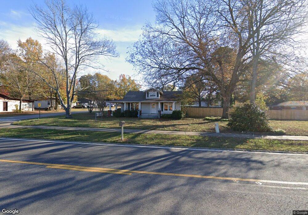
This home is located at 72 S Pine St, Cabot, AR 72023 and is currently estimated at $178,333, approximately $123 per square foot. 72 S Pine St is a home located in Lonoke County with nearby schools including Central Elementary School, Cabot Junior High North, and Cabot Middle School North.
Ownership History
Date
Name
Owned For
Owner Type
Purchase Details
Closed on
Jan 22, 2015
Sold by
Macwell Jerrel
Bought by
Robert M Schelle And Bettye A Schelle Re
Current Estimated Value
Home Financials for this Owner
Home Financials are based on the most recent Mortgage that was taken out on this home.
Original Mortgage
$157,600
Outstanding Balance
$120,937
Interest Rate
3.89%
Mortgage Type
New Conventional
Estimated Equity
$57,396
Purchase Details
Closed on
Dec 6, 2004
Bought by
Jr Maxwell
Purchase Details
Closed on
May 9, 2003
Bought by
Maxwell and Maxwell Wf
Purchase Details
Closed on
Jun 27, 2000
Bought by
Maxwells
Purchase Details
Closed on
Jul 13, 1984
Bought by
Holland and Wife Mary
Create a Home Valuation Report for This Property
The Home Valuation Report is an in-depth analysis detailing your home's value as well as a comparison with similar homes in the area
Purchase History
| Date | Buyer | Sale Price | Title Company |
|---|---|---|---|
| Robert M Schelle And Bettye A Schelle Re | $197,000 | Attorney | |
| Jr Maxwell | $90,000 | -- | |
| Maxwell | -- | -- | |
| Maxwells | $30,000 | -- | |
| Holland | $16,000 | -- |
Source: Public Records
Mortgage History
| Date | Status | Borrower | Loan Amount |
|---|---|---|---|
| Open | Robert M Schelle And Bettye A Schelle Re | $157,600 |
Source: Public Records
Tax History
| Year | Tax Paid | Tax Assessment Tax Assessment Total Assessment is a certain percentage of the fair market value that is determined by local assessors to be the total taxable value of land and additions on the property. | Land | Improvement |
|---|---|---|---|---|
| 2025 | $1,064 | $21,220 | $2,400 | $18,820 |
| 2024 | $1,064 | $21,220 | $2,400 | $18,820 |
| 2023 | $1,064 | $21,220 | $2,400 | $18,820 |
| 2022 | $982 | $21,220 | $2,400 | $18,820 |
| 2021 | $900 | $21,220 | $2,400 | $18,820 |
| 2020 | $818 | $16,080 | $2,400 | $13,680 |
| 2019 | $818 | $16,080 | $2,400 | $13,680 |
| 2018 | $794 | $16,080 | $2,400 | $13,680 |
| 2017 | $738 | $16,080 | $2,400 | $13,680 |
| 2016 | $794 | $16,080 | $2,400 | $13,680 |
| 2015 | $705 | $15,350 | $2,400 | $12,950 |
| 2014 | $758 | $15,350 | $2,400 | $12,950 |
Source: Public Records
Map
Nearby Homes
- 113 Walnut St
- 110 N Monroe St
- 211 N Jackson St
- 509 E Myrtle St
- 907 N Lincoln St
- 0 Adams St Unit 1314912
- Lots 5 & 6 N Adams St
- 109 Pin Oak Dr
- 16 Meadowlark Dr
- 23 Robinson St
- 51 Meadowlark Dr
- 406 N 3rd St
- 00 Kerr Station Rd
- 23 Blueberry Ln
- 12 Blueberry Ln
- 10 Blueberry Ln
- 19 Sycamore St
- 210 W Cherry St
- 613 N 4th St
- 49 Oak Meadows Dr
- 304 N Monroe St
- 68 S Pine St
- 68 S Pine St
- 307 N Monroe St
- 305 N Madison St
- 300 N Monroe St
- 210-210.5 N Monroe St
- 301 N Madison St
- 305 N Monroe St
- 301 N Monroe St
- 301 N Monroe St
- 211 N Monroe St
- 210 N Monroe St
- 209 N Monroe St
- 213 N Madison St
- 300 N Madison St
- 306 N Madison St
- 211 N Madison St
- 209 Madison
- 207 N Monroe St
Your Personal Tour Guide
Ask me questions while you tour the home.