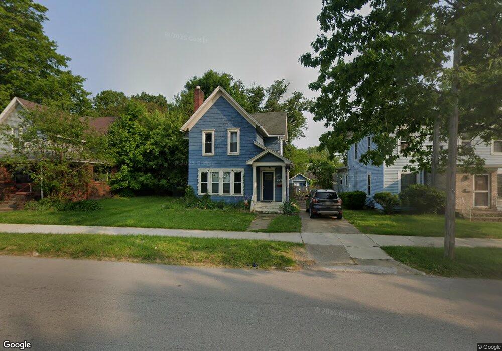
720 Main St Conneaut, OH 44030
Estimated Value: $80,000 - $125,000
3
Beds
1
Bath
1,686
Sq Ft
$58/Sq Ft
Est. Value
About This Home
This home is located at 720 Main St, Conneaut, OH 44030 and is currently estimated at $97,365, approximately $57 per square foot. 720 Main St is a home located in Ashtabula County with nearby schools including Lakeshore Primary Elementary School, Gateway Elementary School, and Conneaut Middle School.
Ownership History
Date
Name
Owned For
Owner Type
Purchase Details
Closed on
May 24, 2011
Sold by
Peterson Thomas F
Bought by
Sabo Ronald J and Sabo Janet C
Current Estimated Value
Home Financials for this Owner
Home Financials are based on the most recent Mortgage that was taken out on this home.
Original Mortgage
$28,000
Interest Rate
4.96%
Mortgage Type
New Conventional
Purchase Details
Closed on
Nov 11, 2008
Sold by
Peterson Thomas F
Bought by
Peterson Thomas F and Declaration Of Trust Of Thomas F Peterso
Purchase Details
Closed on
Nov 3, 2004
Sold by
Manufacturers & Traders Trust Co
Bought by
Peterson Thomas F
Purchase Details
Closed on
Jun 21, 2004
Sold by
Butts Ronnie R and Butts Pamela S
Bought by
Manufacturers & Traders Trust Co
Create a Home Valuation Report for This Property
The Home Valuation Report is an in-depth analysis detailing your home's value as well as a comparison with similar homes in the area
Home Values in the Area
Average Home Value in this Area
Purchase History
| Date | Buyer | Sale Price | Title Company |
|---|---|---|---|
| Sabo Ronald J | $35,000 | Chicago Title | |
| Peterson Thomas F | -- | Attorney | |
| Peterson Thomas F | $47,900 | Sovereign Title Agency Llc | |
| Manufacturers & Traders Trust Co | $44,000 | -- |
Source: Public Records
Mortgage History
| Date | Status | Borrower | Loan Amount |
|---|---|---|---|
| Previous Owner | Sabo Ronald J | $28,000 |
Source: Public Records
Tax History
| Year | Tax Paid | Tax Assessment Tax Assessment Total Assessment is a certain percentage of the fair market value that is determined by local assessors to be the total taxable value of land and additions on the property. | Land | Improvement |
|---|---|---|---|---|
| 2024 | $1,206 | $16,490 | $2,770 | $13,720 |
| 2023 | $785 | $16,490 | $2,770 | $13,720 |
| 2022 | $687 | $12,680 | $2,140 | $10,540 |
| 2021 | $698 | $12,680 | $2,140 | $10,540 |
| 2020 | $698 | $12,680 | $2,140 | $10,540 |
| 2019 | $559 | $9,940 | $1,470 | $8,470 |
| 2018 | $534 | $9,940 | $1,470 | $8,470 |
| 2017 | $625 | $9,940 | $1,470 | $8,470 |
| 2016 | $711 | $14,530 | $2,140 | $12,390 |
| 2015 | $718 | $14,530 | $2,140 | $12,390 |
| 2014 | $636 | $14,530 | $2,140 | $12,390 |
| 2013 | $677 | $15,930 | $2,350 | $13,580 |
Source: Public Records
Map
Nearby Homes
- 745 Maple Ave
- 681 Madison St
- 238 Whitney St
- 855 Spring St Unit S9
- 536 Madison St
- 475 State St
- 474 Sherman St
- 110 Edgewood Dr
- 18 Hillcrest Ct
- 375 Bliss Ave
- 555 Wrights Ave
- 450 Buffalo St
- 386 Washington St
- 179 Marshall St
- 166 Welton Rd
- 284 Clay St
- 716 Chestnut St
- 404 Viaduct St
- 146 Nickle Plate Ave
- 210 W Main Rd
Your Personal Tour Guide
Ask me questions while you tour the home.