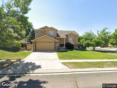
720 Piros Dr Colorado Springs, CO 80922
Springs Ranch NeighborhoodEstimated Value: $441,934 - $486,000
3
Beds
3
Baths
1,802
Sq Ft
$260/Sq Ft
Est. Value
About This Home
This home is located at 720 Piros Dr, Colorado Springs, CO 80922 and is currently estimated at $468,484, approximately $259 per square foot. 720 Piros Dr is a home located in El Paso County with nearby schools including Remington Elementary School, Horizon Middle School, and Sand Creek High School.
Ownership History
Date
Name
Owned For
Owner Type
Purchase Details
Closed on
Aug 4, 2000
Sold by
Coats Robert V and Coats Patricia A
Bought by
Wales Gregory S and Wales Maricon B
Current Estimated Value
Home Financials for this Owner
Home Financials are based on the most recent Mortgage that was taken out on this home.
Original Mortgage
$178,398
Interest Rate
8.15%
Mortgage Type
VA
Purchase Details
Closed on
Oct 24, 1996
Sold by
Watt Residential Partners
Bought by
Coats Robert Vaughn and Coats Patricia Annette
Home Financials for this Owner
Home Financials are based on the most recent Mortgage that was taken out on this home.
Original Mortgage
$145,250
Interest Rate
8.15%
Purchase Details
Closed on
Nov 21, 1990
Bought by
Wales Maricon B
Create a Home Valuation Report for This Property
The Home Valuation Report is an in-depth analysis detailing your home's value as well as a comparison with similar homes in the area
Home Values in the Area
Average Home Value in this Area
Purchase History
| Date | Buyer | Sale Price | Title Company |
|---|---|---|---|
| Wales Gregory S | $174,900 | -- | |
| Coats Robert Vaughn | $152,913 | Security Title | |
| Wales Maricon B | -- | -- |
Source: Public Records
Mortgage History
| Date | Status | Borrower | Loan Amount |
|---|---|---|---|
| Open | Wales Gregory S | $180,850 | |
| Closed | Wales Gregory S | $180,850 | |
| Closed | Wales Gregory S | $178,398 | |
| Previous Owner | Coats Robert Vaughn | $145,250 |
Source: Public Records
Tax History Compared to Growth
Tax History
| Year | Tax Paid | Tax Assessment Tax Assessment Total Assessment is a certain percentage of the fair market value that is determined by local assessors to be the total taxable value of land and additions on the property. | Land | Improvement |
|---|---|---|---|---|
| 2024 | $1,582 | $32,150 | $4,620 | $27,530 |
| 2023 | $1,582 | $32,150 | $4,620 | $27,530 |
| 2022 | $1,306 | $22,410 | $4,170 | $18,240 |
| 2021 | $1,362 | $23,060 | $4,290 | $18,770 |
| 2020 | $1,214 | $20,300 | $3,580 | $16,720 |
| 2019 | $1,200 | $20,300 | $3,580 | $16,720 |
| 2018 | $988 | $16,370 | $3,020 | $13,350 |
| 2017 | $993 | $16,370 | $3,020 | $13,350 |
| 2016 | $1,028 | $16,710 | $2,950 | $13,760 |
| 2015 | $1,029 | $16,710 | $2,950 | $13,760 |
| 2014 | $982 | $15,640 | $2,790 | $12,850 |
Source: Public Records
Map
Nearby Homes
- 660 Piros Dr
- 3130 Haystack Dr
- 3062 Pony Tracks Dr
- 6555 Turkey Tracks Rd
- 3510 Pony Tracks Dr
- 3064 Curly Grove
- 3052 Curly Grove
- 3077 Curly Grove
- 3065 Curly Grove
- 3071 Curly Grove
- 3323 Evening Breeze Dr
- 3327 Evening Breeze Dr
- 3351 Evening Breeze Dr
- 3355 Evening Breeze Dr
- 3511 Greenways Main Blvd
- 3523 Greenways Main Blvd
- 3529 Greenways Main Blvd
- 3359 Evening Breeze Dr
- 3535 Greenways Main Blvd
- 3541 Greenways Main Blvd
- 720 Piros Dr
- 710 Piros Dr
- 3185 Ox Cart Dr
- 680 Piros Dr
- 3175 Ox Cart Dr
- 3190 Ox Cart Dr
- 3180 Ox Cart Dr
- 725 Piros Dr
- 715 Piros Dr
- 6520 Campfire Ct
- 735 Piros Dr
- 3170 Ox Cart Dr
- 670 Piros Dr
- 6530 Campfire Ct
- 3165 Ox Cart Dr
- 685 Piros Dr
- 745 Piros Dr
- 3160 Ox Cart Dr
- 3245 Pony Tracks Dr
- 3235 Pony Tracks Dr