
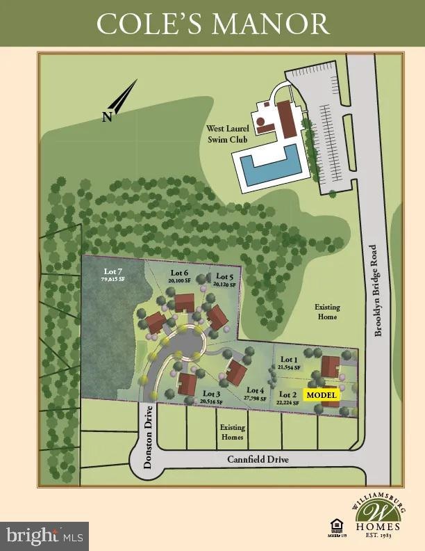

7209 Brooklyn Bridge Rd Laurel, MD 20707
West Laurel NeighborhoodEstimated payment $5,803/month
Highlights
- New Construction
- Colonial Architecture
- Forced Air Heating and Cooling System
- 0.47 Acre Lot
- 2 Car Attached Garage
- Property is in excellent condition
About This Home
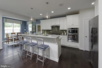
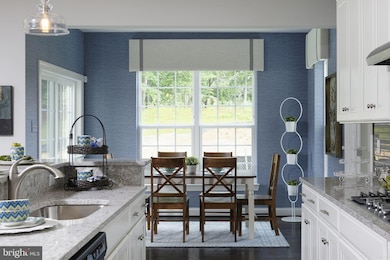
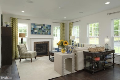
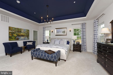
PRE Construction Pricing- $50,000 in FREE OPTIONS and $10K in Closing help by the builder using their preferred title and lender . Discover the charm of this stunning new construction home, set to be completed in 2026, nestled in a serene neighborhood that offers a perfect blend of comfort and community. This Colonial-style residence boasts a spacious layout with 4 bedrooms and 3.5 bathrooms, ideal for creating lasting memories. Step inside to find a beautifully designed interior featuring a fully finished basement with walkout stairs, providing ample space for entertainment or relaxation. The heart of the home is the inviting kitchen, equipped with modern appliances including a cooktop, built-in microwave, dishwasher, and a single oven, making meal preparation a delight. Cozy up by the gas fireplace, perfect for those chilly evenings. The property sits on a generous 0.47-acre lot, offering plenty of outdoor space for gardening or play. With an attached front-entry garage accommodating two vehicles, convenience is at your fingertips. Located in a vibrant community, residents enjoy easy access to local parks, schools, and public services, fostering a sense of belonging. Explore nearby recreational areas, perfect for weekend outings,. This home is not just a place to live; it’s a gateway to a lifestyle filled with warmth, connection, and endless possibilities. Embrace the opportunity to make this beautiful residence your own and become part of a welcoming community.
Listing Agent
(443) 250-6395 cindy@northropteam.com Northrop Realty License #523434 Listed on: 10/17/2025

Home Details
Home Type
- Single Family
Est. Annual Taxes
- $5,214
Year Built
- New Construction
Lot Details
- 0.47 Acre Lot
- Property is in excellent condition
HOA Fees
- $125 Monthly HOA Fees
Parking
- 2 Car Attached Garage
- Front Facing Garage
Home Design
- Colonial Architecture
- Vinyl Siding
- Passive Radon Mitigation
- Rough-In Plumbing
Interior Spaces
- 2,774 Sq Ft Home
- Property has 3 Levels
- Heatilator
- Gas Fireplace
Kitchen
- Oven
- Cooktop with Range Hood
- Built-In Microwave
- Dishwasher
Bedrooms and Bathrooms
- 4 Main Level Bedrooms
Finished Basement
- Walk-Out Basement
- Basement Fills Entire Space Under The House
- Interior Basement Entry
Schools
- Laurel High School
Utilities
- Forced Air Heating and Cooling System
- Heating System Uses Natural Gas
- Heat Pump System
- Electric Water Heater
Community Details
- $104 Other Monthly Fees
- Built by Williamsburg
- Adrienne's Honnuer
Map
Home Values in the Area
Average Home Value in this Area
Tax History
| Year | Tax Paid | Tax Assessment Tax Assessment Total Assessment is a certain percentage of the fair market value that is determined by local assessors to be the total taxable value of land and additions on the property. | Land | Improvement |
|---|---|---|---|---|
| 2025 | $5,214 | $128,600 | $128,600 | -- |
| 2024 | $5,214 | $324,000 | $0 | $0 |
| 2023 | $4,158 | $305,200 | $0 | $0 |
| 2022 | $3,958 | $286,400 | $108,000 | $178,400 |
| 2021 | $3,822 | $279,533 | $0 | $0 |
| 2020 | $3,768 | $272,667 | $0 | $0 |
| 2019 | $3,694 | $265,800 | $108,000 | $157,800 |
| 2018 | $3,563 | $250,867 | $0 | $0 |
| 2017 | $3,453 | $235,933 | $0 | $0 |
| 2016 | -- | $221,000 | $0 | $0 |
| 2015 | $3,095 | $221,000 | $0 | $0 |
| 2014 | $3,095 | $221,000 | $0 | $0 |
Property History
| Date | Event | Price | List to Sale | Price per Sq Ft |
|---|---|---|---|---|
| 10/17/2025 10/17/25 | For Sale | $994,836 | -- | $359 / Sq Ft |
Purchase History
| Date | Type | Sale Price | Title Company |
|---|---|---|---|
| Personal Reps Deed | $825,000 | Lakeside Title | |
| Personal Reps Deed | $825,000 | Lakeside Title |
Mortgage History
| Date | Status | Loan Amount | Loan Type |
|---|---|---|---|
| Previous Owner | $1,387,500 | New Conventional |
Source: Bright MLS
MLS Number: MDPG2180088
APN: 10-1010545
Disclaimer: Certain information contained herein is derived from information provided by parties other than Homes.com. All information provided is deemed reliable, but is not guaranteed to be accurate and should be independently verified.
![]() The data relating to real estate for sale on this website appears in part through the BRIGHT Internet Data Exchange program, a voluntary cooperative exchange of property listing data between licensed real estate brokerage firms, and is provided by BRIGHT through a licensing agreement.
The data relating to real estate for sale on this website appears in part through the BRIGHT Internet Data Exchange program, a voluntary cooperative exchange of property listing data between licensed real estate brokerage firms, and is provided by BRIGHT through a licensing agreement.
Listing information is from various brokers who participate in the Bright MLS IDX program and not all listings may be visible on the site.
The property information being provided on or through the website is for the personal, non-commercial use of consumers and such information may not be used for any purpose other than to identify prospective properties consumers may be interested in purchasing.
Some properties which appear for sale on the website may no longer be available because they are for instance, under contract, sold or are no longer being offered for sale.
Property information displayed is deemed reliable but is not guaranteed.
Copyright 2025 Bright MLS, Inc.
- Dorchester IV Plan at Cole's Manor
- Tidewater Plan at Cole's Manor
- Stratton Plan at Cole's Manor
- Adrienne's Honneur II Plan at Cole's Manor
- Mount Vernon IV Villa 2 Plan at Cole's Manor
- Federal Hill II Plan at Cole's Manor
- 16140 Kenny Rd
- 7019 Redmiles Rd
- 7019 Fitzpatrick Dr
- 7011 Fitzpatrick Dr
- 7619 Woodbine Dr
- 7323 Split Rail Ln
- 15712 Dorset Rd Unit T3
- 15708 Dorset Rd Unit 203
- 15708 Dorset Rd Unit 304
- 16035 Dorset Rd
- 7709 Brooklyn Bridge Rd
- 6901 Fitzpatrick Dr
- 6942 Scotch Dr
- 6802 Niles Dr
- 7307 Brooklyn Bridge Rd
- 15839 Millbrook Ln
- 15808 Haynes Rd
- 7723 Haines Ct
- 7643 Arbory Ct
- 7607 E Arbory Ct
- 7664 E Arbory Ct
- 9887 Deer Run
- 9210 Deer Village Dr
- 214 10th St
- 8916 Pembrook Woods
- 14903 Rockcastle St
- 902 7th St Unit .5
- 926 West St
- 14910 Cherrywood Dr
- 8607 Woods End Dr
- 8297 Londonderry Ct
- 9232 Pinenut Ct
- 607 7th St Unit 100,201
- 8301 Ashford Blvd