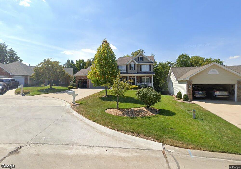
721 Jamesport Dr O Fallon, MO 63366
Estimated Value: $522,000 - $563,000
4
Beds
4
Baths
3,435
Sq Ft
$158/Sq Ft
Est. Value
About This Home
This home is located at 721 Jamesport Dr, O Fallon, MO 63366 and is currently estimated at $542,690, approximately $157 per square foot. 721 Jamesport Dr is a home located in St. Charles County with nearby schools including Westhoff Elementary School, Fort Zumwalt North Middle School, and Fort Zumwalt North High School.
Ownership History
Date
Name
Owned For
Owner Type
Purchase Details
Closed on
Jun 12, 2015
Sold by
Corr Shane P and Corr Kendra L
Bought by
The Corr Family Revocable Living Trust
Current Estimated Value
Purchase Details
Closed on
Aug 31, 2007
Sold by
T R Hughes Inc
Bought by
Corr Shane and Corr Kendra
Home Financials for this Owner
Home Financials are based on the most recent Mortgage that was taken out on this home.
Original Mortgage
$45,000
Interest Rate
6.7%
Mortgage Type
Credit Line Revolving
Create a Home Valuation Report for This Property
The Home Valuation Report is an in-depth analysis detailing your home's value as well as a comparison with similar homes in the area
Home Values in the Area
Average Home Value in this Area
Purchase History
| Date | Buyer | Sale Price | Title Company |
|---|---|---|---|
| The Corr Family Revocable Living Trust | -- | None Available | |
| Corr Shane | -- | Grt | |
| Tr Hughes Inc | -- | Grt |
Source: Public Records
Mortgage History
| Date | Status | Borrower | Loan Amount |
|---|---|---|---|
| Previous Owner | Tr Hughes Inc | $45,000 | |
| Previous Owner | Corr Shane | $265,000 |
Source: Public Records
Tax History Compared to Growth
Tax History
| Year | Tax Paid | Tax Assessment Tax Assessment Total Assessment is a certain percentage of the fair market value that is determined by local assessors to be the total taxable value of land and additions on the property. | Land | Improvement |
|---|---|---|---|---|
| 2025 | $5,952 | $98,391 | -- | -- |
| 2023 | $5,954 | $90,304 | $0 | $0 |
| 2022 | $5,354 | $75,546 | $0 | $0 |
| 2021 | $5,359 | $75,546 | $0 | $0 |
| 2020 | $4,608 | $62,815 | $0 | $0 |
| 2019 | $4,618 | $62,815 | $0 | $0 |
| 2018 | $4,492 | $58,335 | $0 | $0 |
| 2017 | $4,444 | $58,335 | $0 | $0 |
| 2016 | $4,132 | $54,023 | $0 | $0 |
| 2015 | $3,841 | $54,023 | $0 | $0 |
| 2014 | $3,912 | $54,082 | $0 | $0 |
Source: Public Records
Map
Nearby Homes
- 1401 Noyack Dr
- 12 Warshire Ct Unit 67A
- 1113 Renfrew Ln S
- 166 Maryland Dr
- 2 England Cir
- 306 Estate Dr
- 223 England Dr
- 320 Camilla Dr
- 107 Roxbury Dr
- 8 Dugout Ct
- 103 Roxbury Dr
- 1384 Deerfield Estates Dr
- 992 Tilestone Dr
- 419 Dames Park Dr
- 409 Dames Park Dr
- 18 Homefield Gardens Dr Unit 21N
- 18 W Homefield Point Ct
- Lot 2 Homefield Blvd
- 2024 Homefield Ridge Dr
- 117.76 Acres Missouri 79
- 723 Jamesport Dr
- 719 Jamesport Dr
- 717 Jamesport Dr
- 722 Jamesport Dr
- 715 Jamesport Dr
- 716 Jamesport Dr
- 727 Jamesport Dr
- 724 Jamesport Dr
- 713 Jamesport Dr
- 712 Jamesport Dr
- 728 Jamesport Dr
- 726 Jamesport Dr
- 711 Jamesport Dr
- 1627 Wainscott Ct
- 710 Jamesport Dr
- 1631 Wainscott Ct
- 2021 Old Highway 79
- 1623 Wainscott Ct
- 709 Jamesport Dr
- 1635 Wainscott Ct