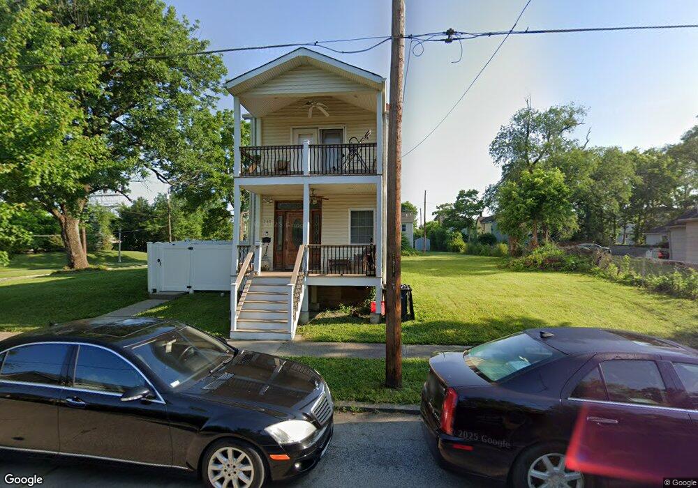
722 Maple St Wyoming, OH 45215
Estimated Value: $168,000 - $207,000
4
Beds
2
Baths
1,924
Sq Ft
$100/Sq Ft
Est. Value
About This Home
This home is located at 722 Maple St, Wyoming, OH 45215 and is currently estimated at $192,638, approximately $100 per square foot. 722 Maple St is a home located in Hamilton County with nearby schools including Lockland Elementary School, Lockland Middle School, and Lockland High School.
Ownership History
Date
Name
Owned For
Owner Type
Purchase Details
Closed on
Apr 13, 2005
Sold by
Abn Amro Mortgage Group Inc
Bought by
Baxter Construction Inc
Current Estimated Value
Purchase Details
Closed on
Jun 30, 2004
Sold by
Howard Monica
Bought by
Abn Amro Mortgage Group Inc
Purchase Details
Closed on
Jan 11, 2002
Sold by
Moody Charles T and Moody Stephanie B
Bought by
Howard Monica
Home Financials for this Owner
Home Financials are based on the most recent Mortgage that was taken out on this home.
Original Mortgage
$80,000
Interest Rate
6.92%
Purchase Details
Closed on
Jan 22, 1998
Sold by
Moody Georgia Mae
Bought by
Moody Charles T
Purchase Details
Closed on
Oct 16, 1996
Sold by
Dillingham Scott
Bought by
Moody Georgia Mae
Create a Home Valuation Report for This Property
The Home Valuation Report is an in-depth analysis detailing your home's value as well as a comparison with similar homes in the area
Home Values in the Area
Average Home Value in this Area
Purchase History
| Date | Buyer | Sale Price | Title Company |
|---|---|---|---|
| Baxter Construction Inc | $5,000 | Resource Title Agency Inc | |
| Abn Amro Mortgage Group Inc | $6,000 | -- | |
| Howard Monica | $100,000 | Jets Title Agency Llc | |
| Moody Charles T | -- | -- | |
| Moody Georgia Mae | $20,000 | -- |
Source: Public Records
Mortgage History
| Date | Status | Borrower | Loan Amount |
|---|---|---|---|
| Previous Owner | Howard Monica | $80,000 |
Source: Public Records
Tax History
| Year | Tax Paid | Tax Assessment Tax Assessment Total Assessment is a certain percentage of the fair market value that is determined by local assessors to be the total taxable value of land and additions on the property. | Land | Improvement |
|---|---|---|---|---|
| 2025 | $2,655 | $47,139 | $3,322 | $43,817 |
| 2023 | $2,681 | $47,139 | $3,322 | $43,817 |
| 2022 | $2,852 | $40,261 | $2,356 | $37,905 |
| 2021 | $2,887 | $40,261 | $2,356 | $37,905 |
| 2020 | $2,473 | $40,261 | $2,356 | $37,905 |
| 2019 | $2,656 | $40,261 | $2,356 | $37,905 |
| 2018 | $2,615 | $40,261 | $2,356 | $37,905 |
| 2017 | $2,492 | $40,261 | $2,356 | $37,905 |
| 2016 | $1,843 | $29,866 | $2,513 | $27,353 |
| 2015 | $1,712 | $29,866 | $2,513 | $27,353 |
| 2014 | $1,707 | $29,866 | $2,513 | $27,353 |
| 2013 | $1,633 | $29,281 | $2,464 | $26,817 |
Source: Public Records
Map
Nearby Homes
- 127 Locust St
- 701 W Wyoming Ave
- 454 Hillside Ave
- 221 Crescent Ave
- 217 W Wyoming Ave
- 405 Home Ave
- 177 Burns Ave
- 313 Pershing Ave
- 324 Beech Ave
- 414 Jonte Ave
- 401 Jonte Ave
- 519 Westview Ave
- 1076 Schumard Ave
- 29 Forest Ave
- 857 Steffen Ave
- 1239 Springfield Pike
- 320 Reily Rd
- 26 W Mills Ave
- 1282 Steffen Ave
- 1012 Mary Ln
Your Personal Tour Guide
Ask me questions while you tour the home.