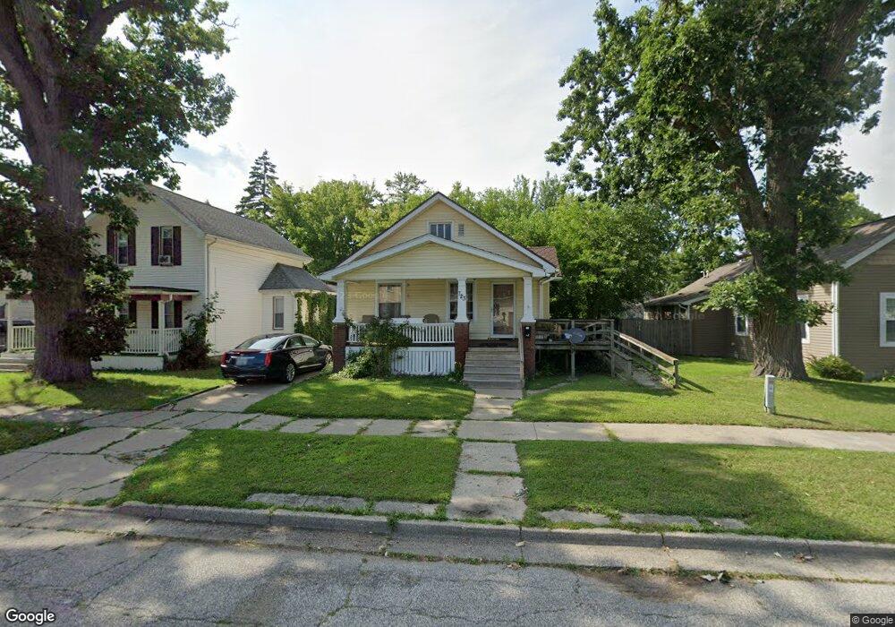
723 N Porter St Saginaw, MI 48602
Covenant NeighborhoodEstimated Value: $60,000 - $75,000
3
Beds
1
Bath
1,078
Sq Ft
$64/Sq Ft
Est. Value
About This Home
This home is located at 723 N Porter St, Saginaw, MI 48602 and is currently estimated at $68,862, approximately $63 per square foot. 723 N Porter St is a home located in Saginaw County with nearby schools including Herig Elementary School, Thompson Middle School, and Arthur Hill High School.
Ownership History
Date
Name
Owned For
Owner Type
Purchase Details
Closed on
Nov 30, 2001
Sold by
Delgado Juan and Delgado Jesusa
Bought by
Henton Anquish L
Current Estimated Value
Purchase Details
Closed on
Jan 26, 1993
Sold by
Strunk Doris M
Bought by
Delgado Juan and Delgado Jesusa
Purchase Details
Closed on
Nov 28, 1990
Sold by
Bauer Theresa
Bought by
Bauer Theresa and Strunk Doris M
Purchase Details
Closed on
Aug 13, 1983
Sold by
Bauer Theresa and Bauer Orrin
Bought by
Bauer Theresa and Bauer Gale R
Create a Home Valuation Report for This Property
The Home Valuation Report is an in-depth analysis detailing your home's value as well as a comparison with similar homes in the area
Home Values in the Area
Average Home Value in this Area
Purchase History
| Date | Buyer | Sale Price | Title Company |
|---|---|---|---|
| Henton Anquish L | $43,500 | -- | |
| Henton Anquish Lashon | $43,500 | Metropolitan Title Company | |
| Delgado Juan | $26,800 | -- | |
| Bauer Theresa | -- | -- | |
| Bauer Theresa | -- | -- |
Source: Public Records
Tax History Compared to Growth
Tax History
| Year | Tax Paid | Tax Assessment Tax Assessment Total Assessment is a certain percentage of the fair market value that is determined by local assessors to be the total taxable value of land and additions on the property. | Land | Improvement |
|---|---|---|---|---|
| 2025 | $1,292 | $26,400 | $0 | $0 |
| 2024 | $1,045 | $24,600 | $0 | $0 |
| 2023 | $1,016 | $21,100 | $0 | $0 |
| 2022 | $1,246 | $18,000 | $0 | $0 |
| 2021 | $1,173 | $16,800 | $0 | $0 |
| 2020 | $1,002 | $15,900 | $0 | $0 |
| 2019 | $1,000 | $15,500 | $900 | $14,600 |
| 2018 | $778 | $15,523 | $0 | $0 |
| 2017 | $907 | $14,750 | $0 | $0 |
| 2016 | $874 | $14,665 | $0 | $0 |
| 2014 | -- | $16,001 | $0 | $14,919 |
| 2013 | -- | $16,028 | $0 | $0 |
Source: Public Records
Map
Nearby Homes
- 717 N Porter St
- 709 N Granger St
- 1121 Throop St
- 516 N Granger St
- 513 N Webster St
- 513 N Oakley St
- 902 N Mason St
- 413 N Bond St
- 412 N Oakley St
- 401 N Porter St
- 620 Madison St
- 800 W Remington St
- 1509 Monroe St
- 1014 Hancock St
- 203 N Webster St
- 1603 Cooper Ave
- 211 N Woodbridge St
- 2016 Houghton Ave
- 1610 Cleveland St
- 129 N Mason St
- 729 N Porter St
- 713 N Porter St
- 1015 Throop St
- 707 N Porter St Unit 1
- 707 N Porter #1 St
- 707 N Porter #1 St Unit 1 Main
- 707 N Porter #2 St Unit Upper
- 707 N Porter #2 St
- 722 N Porter St
- 716 N Porter St
- 718 N Bond St
- 1021 Throop St
- 712 N Bond St
- 712 N Porter St
- 921 Throop St
- 803 N Porter St
- 1008 Throop St
- 703 N Porter St
- 915 Throop St
- 706 N Porter St