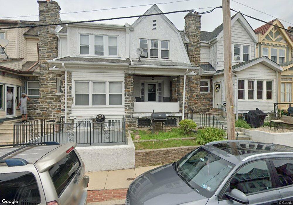
7235 Calvin Rd Upper Darby, PA 19082
Estimated Value: $166,000 - $220,022
3
Beds
2
Baths
1,528
Sq Ft
$128/Sq Ft
Est. Value
About This Home
This home is located at 7235 Calvin Rd, Upper Darby, PA 19082 and is currently estimated at $195,256, approximately $127 per square foot. 7235 Calvin Rd is a home located in Delaware County with nearby schools including Bywood Elementary School, Upper Darby Kdg Center, and Upper Darby High School.
Ownership History
Date
Name
Owned For
Owner Type
Purchase Details
Closed on
Sep 13, 2004
Sold by
Noldy Walter D and Noldy Sandra T
Bought by
Seya Roger I
Current Estimated Value
Home Financials for this Owner
Home Financials are based on the most recent Mortgage that was taken out on this home.
Original Mortgage
$85,400
Outstanding Balance
$42,704
Interest Rate
6.02%
Mortgage Type
Fannie Mae Freddie Mac
Estimated Equity
$152,552
Create a Home Valuation Report for This Property
The Home Valuation Report is an in-depth analysis detailing your home's value as well as a comparison with similar homes in the area
Home Values in the Area
Average Home Value in this Area
Purchase History
| Date | Buyer | Sale Price | Title Company |
|---|---|---|---|
| Seya Roger I | $89,900 | -- |
Source: Public Records
Mortgage History
| Date | Status | Borrower | Loan Amount |
|---|---|---|---|
| Open | Seya Roger I | $85,400 |
Source: Public Records
Tax History Compared to Growth
Tax History
| Year | Tax Paid | Tax Assessment Tax Assessment Total Assessment is a certain percentage of the fair market value that is determined by local assessors to be the total taxable value of land and additions on the property. | Land | Improvement |
|---|---|---|---|---|
| 2025 | $4,310 | $101,920 | $26,340 | $75,580 |
| 2024 | $4,310 | $101,920 | $26,340 | $75,580 |
| 2023 | $4,270 | $101,920 | $26,340 | $75,580 |
| 2022 | $4,155 | $101,920 | $26,340 | $75,580 |
| 2021 | $5,602 | $101,920 | $26,340 | $75,580 |
| 2020 | $3,878 | $59,950 | $15,580 | $44,370 |
| 2019 | $3,810 | $59,950 | $15,580 | $44,370 |
| 2018 | $3,766 | $59,950 | $0 | $0 |
| 2017 | $3,668 | $59,950 | $0 | $0 |
| 2016 | $329 | $59,950 | $0 | $0 |
| 2015 | $329 | $59,950 | $0 | $0 |
| 2014 | $329 | $59,950 | $0 | $0 |
Source: Public Records
Map
Nearby Homes
- 212 Huntley Rd
- 228 Long Ln
- 234 Long Ln
- 253 Shirley Rd
- 512 Fairfield Ave
- 240 Glendale Rd
- 101 Copley Rd
- 275 Glendale Rd
- 513 Spruce Ave
- 268 Hampden Rd
- 262 Bayard Rd
- 324 Kingston Rd
- 62 Richfield Rd
- 7251 Bradford Rd
- 7114 Locust St
- 107 S Keystone Ave
- 27 Glendale Rd
- 367 Margate Rd
- 351 Long Ln
- 318 Margate Rd