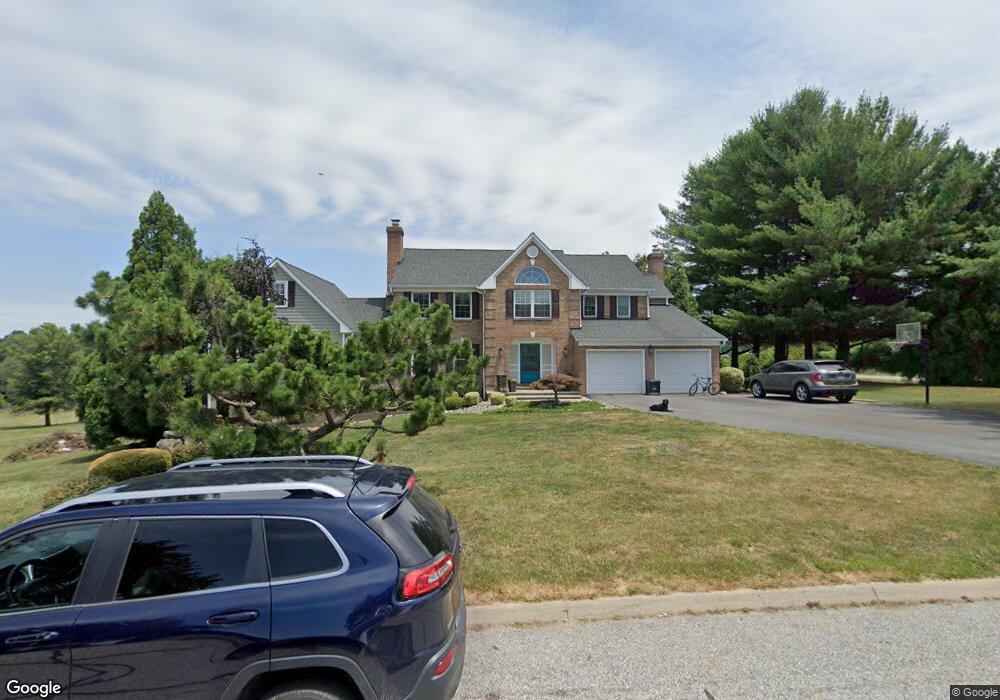
724 Pheasant Dr Forest Hill, MD 21050
Estimated Value: $602,000 - $847,000
Studio
3
Baths
3,123
Sq Ft
$242/Sq Ft
Est. Value
About This Home
This home is located at 724 Pheasant Dr, Forest Hill, MD 21050 and is currently estimated at $755,424, approximately $241 per square foot. 724 Pheasant Dr is a home located in Harford County with nearby schools including Forest Hill Elementary School, North Harford Middle School, and North Harford High School.
Ownership History
Date
Name
Owned For
Owner Type
Purchase Details
Closed on
Oct 24, 2013
Sold by
Schrof Peter F W and Schrof Jennifer S
Bought by
Schrof Jennifer S
Current Estimated Value
Purchase Details
Closed on
Apr 14, 1999
Sold by
Minor Brian D
Bought by
Schrof Peter F W and Schrof Jennifer S
Purchase Details
Closed on
Dec 24, 1998
Sold by
Minor Brian D
Bought by
Minor Brian D and Minor Elizabeth J
Purchase Details
Closed on
Nov 6, 1996
Sold by
Mahon John Keith
Bought by
Minor Brian D and Minor Elizabeth J
Create a Home Valuation Report for This Property
The Home Valuation Report is an in-depth analysis detailing your home's value as well as a comparison with similar homes in the area
Purchase History
| Date | Buyer | Sale Price | Title Company |
|---|---|---|---|
| Schrof Jennifer S | -- | None Available | |
| Schrof Peter F W | $248,000 | -- | |
| Minor Brian D | -- | -- | |
| Minor Brian D | $240,000 | -- |
Source: Public Records
Mortgage History
| Date | Status | Borrower | Loan Amount |
|---|---|---|---|
| Closed | Minor Brian D | -- |
Source: Public Records
Tax History
| Year | Tax Paid | Tax Assessment Tax Assessment Total Assessment is a certain percentage of the fair market value that is determined by local assessors to be the total taxable value of land and additions on the property. | Land | Improvement |
|---|---|---|---|---|
| 2025 | $6,094 | $585,200 | $136,100 | $449,100 |
| 2024 | $6,094 | $553,633 | $0 | $0 |
| 2023 | $5,750 | $522,067 | $0 | $0 |
| 2022 | $5,406 | $490,500 | $136,100 | $354,400 |
| 2021 | $10,932 | $475,633 | $0 | $0 |
| 2020 | $5,377 | $460,767 | $0 | $0 |
| 2019 | $5,206 | $445,900 | $141,100 | $304,800 |
| 2018 | $4,828 | $416,900 | $0 | $0 |
| 2017 | $4,496 | $445,900 | $0 | $0 |
| 2016 | -- | $358,900 | $0 | $0 |
| 2015 | $4,442 | $358,900 | $0 | $0 |
| 2014 | $4,442 | $358,900 | $0 | $0 |
Source: Public Records
Map
Nearby Homes
- 2948 Grier Nursery Rd
- 520 Walters Mill Rd
- 106 Bower Ln
- 209 Christopher Rd
- 2433 Maxa Meadows Ln
- 2419 Edwards Manor Dr
- 2804 Rocks Rd
- 2605 Ady Rd
- 2322 Rock Spring Rd
- 2229-A Ady Rd
- 332 Ponfield Rd E
- 407 Shellbark Ct
- 408 Cherry Hill Rd
- 1986 Esther Ct
- 2033 Mardic Dr
- 2027 Mardic Dr
- 310 Willrich Cir
- 2647 Hoopes Rd
- 2026 Mardic Dr
- 313 Willrich Cir Unit E
- 405 Chestnut Hill Rd
- 721 Pheasant Dr
- 722 Pheasant Dr
- 420 Chestnut Hill Rd
- 403 Chestnut Hill Rd
- 715 Pheasant Dr
- 720 Pheasant Dr
- 719 Pheasant Dr
- 401 Chestnut Hill Rd
- 341 Chestnut Hill Rd
- 717 Pheasant Dr
- 713 Pheasant Dr
- 718 Pheasant Dr
- 729 Pyle Rd
- 710 Pheasant Dr
- 802 Kensington Farm Ct
- 707 Pheasant Dr
- 727 Pyle Rd
- 801 Kensington Farm Ct
- 711 Pheasant Dr
Your Personal Tour Guide
Ask me questions while you tour the home.