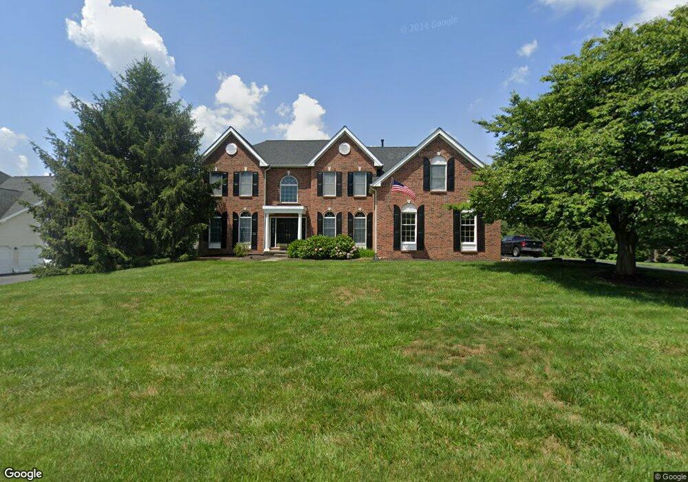
725 Meadowbank Rd Kennett Square, PA 19348
East Marlborough Township NeighborhoodEstimated Value: $1,018,207 - $1,187,000
4
Beds
5
Baths
4,431
Sq Ft
$248/Sq Ft
Est. Value
About This Home
This home is located at 725 Meadowbank Rd, Kennett Square, PA 19348 and is currently estimated at $1,098,302, approximately $247 per square foot. 725 Meadowbank Rd is a home located in Chester County with nearby schools including Unionville Elementary School, Charles F. Patton Middle School, and Unionville High School.
Ownership History
Date
Name
Owned For
Owner Type
Purchase Details
Closed on
Jul 30, 1999
Sold by
Willowdale Crossing Lp
Bought by
Maggitti Michael E and Maggitti Michele A
Current Estimated Value
Home Financials for this Owner
Home Financials are based on the most recent Mortgage that was taken out on this home.
Original Mortgage
$240,000
Outstanding Balance
$68,375
Interest Rate
7.54%
Estimated Equity
$1,029,927
Create a Home Valuation Report for This Property
The Home Valuation Report is an in-depth analysis detailing your home's value as well as a comparison with similar homes in the area
Home Values in the Area
Average Home Value in this Area
Purchase History
| Date | Buyer | Sale Price | Title Company |
|---|---|---|---|
| Maggitti Michael E | $400,771 | -- |
Source: Public Records
Mortgage History
| Date | Status | Borrower | Loan Amount |
|---|---|---|---|
| Open | Maggitti Michael E | $240,000 |
Source: Public Records
Tax History Compared to Growth
Tax History
| Year | Tax Paid | Tax Assessment Tax Assessment Total Assessment is a certain percentage of the fair market value that is determined by local assessors to be the total taxable value of land and additions on the property. | Land | Improvement |
|---|---|---|---|---|
| 2025 | $2,250 | $334,110 | $66,970 | $267,140 |
| 2024 | $2,250 | $334,110 | $66,970 | $267,140 |
| 2023 | $2,250 | $334,110 | $66,970 | $267,140 |
| 2022 | $1,871 | $334,110 | $66,970 | $267,140 |
| 2021 | $2,250 | $334,110 | $66,970 | $267,140 |
| 2020 | $1,811 | $334,110 | $66,970 | $267,140 |
| 2019 | $2,189 | $334,110 | $66,970 | $267,140 |
| 2018 | $2,189 | $334,110 | $66,970 | $267,140 |
| 2017 | $2,189 | $334,110 | $66,970 | $267,140 |
| 2016 | $1,520 | $334,110 | $66,970 | $267,140 |
| 2015 | $1,520 | $334,110 | $66,970 | $267,140 |
| 2014 | $1,520 | $334,110 | $66,970 | $267,140 |
Source: Public Records
Map
Nearby Homes
- 804 Waverly Rd
- 312 Riverbirch Cir Unit 802
- 191 W Street Rd
- 102 Manor Dr
- 347 Astilbe Dr
- 617 Unionville Rd
- 113 Lantana Dr
- 213 Katsura Dr
- 1776 W Doe Run Rd
- 505 Wisteria Dr
- 454 Larkspur Dr
- 217 Kirkbrae Rd
- 711 Potter Dr
- 705 Potter Dr
- 326 Redbud Ln
- 380 Upland Rd
- 907 Mitchell Farm Ln
- 24 Radnor Ln
- 491 N Mill Rd
- 736 Cascade Way
- 723 Meadowbank Rd
- 727 Meadowbank Rd
- 284 Avonwood Rd
- 302 Rose Glen Ln
- 607 Monticello Ln
- 282 Avonwood Rd
- 729 Meadowbank Rd
- 605 Monticello Ln
- 603 Monticello Ln
- 303 Rose Glen Ln
- 609 Monticello Ln
- 280 Avonwood Rd
- 283 Avonwood Rd
- 281 Avonwood Rd
- 402 Brentford Rd
- 279 Avonwood Rd
- 733 Meadowbank Rd
- 304 Rose Glen Ln
- 203 Avonwood Rd
- 305 Rose Glen Ln