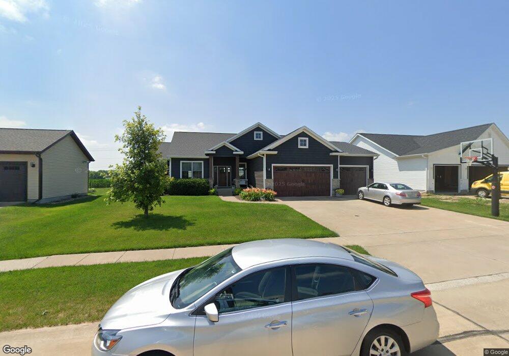
725 St Andrews Cir Eldridge, IA 52748
Estimated Value: $471,000 - $579,000
4
Beds
6
Baths
1,796
Sq Ft
$294/Sq Ft
Est. Value
About This Home
This home is located at 725 St Andrews Cir, Eldridge, IA 52748 and is currently estimated at $527,738, approximately $293 per square foot. 725 St Andrews Cir is a home located in Scott County with nearby schools including Alan Shepard Elementary School, North Scott Junior High School, and North Scott Senior High School.
Ownership History
Date
Name
Owned For
Owner Type
Purchase Details
Closed on
Apr 9, 2021
Sold by
Hanna Kerri M and Hurning Kerri M
Bought by
Hurning Kerri M and Hurning James I
Current Estimated Value
Home Financials for this Owner
Home Financials are based on the most recent Mortgage that was taken out on this home.
Original Mortgage
$266,300
Outstanding Balance
$188,903
Interest Rate
2.3%
Mortgage Type
New Conventional
Estimated Equity
$338,835
Purchase Details
Closed on
Nov 23, 2016
Sold by
Oetzmann Builders Llc
Bought by
Hanna Kerri M
Create a Home Valuation Report for This Property
The Home Valuation Report is an in-depth analysis detailing your home's value as well as a comparison with similar homes in the area
Home Values in the Area
Average Home Value in this Area
Purchase History
| Date | Buyer | Sale Price | Title Company |
|---|---|---|---|
| Hurning Kerri M | -- | None Listed On Document | |
| Hanna Kerri M | $350,000 | None Available |
Source: Public Records
Mortgage History
| Date | Status | Borrower | Loan Amount |
|---|---|---|---|
| Open | Hurning Kerri M | $266,300 |
Source: Public Records
Tax History
| Year | Tax Paid | Tax Assessment Tax Assessment Total Assessment is a certain percentage of the fair market value that is determined by local assessors to be the total taxable value of land and additions on the property. | Land | Improvement |
|---|---|---|---|---|
| 2025 | $5,238 | $438,800 | $85,800 | $353,000 |
| 2024 | $5,102 | $418,900 | $85,800 | $333,100 |
| 2023 | $5,744 | $418,900 | $85,800 | $333,100 |
| 2022 | $5,566 | $403,830 | $77,600 | $326,230 |
| 2021 | $5,566 | $403,830 | $77,600 | $326,230 |
| 2020 | $5,612 | $398,500 | $77,600 | $320,900 |
| 2019 | $5,862 | $398,500 | $77,600 | $320,900 |
| 2018 | $5,984 | $398,500 | $77,600 | $320,900 |
| 2017 | $2,216 | $398,500 | $77,600 | $320,900 |
| 2016 | $116 | $7,500 | $0 | $0 |
| 2015 | -- | $0 | $0 | $0 |
| 2014 | -- | $0 | $0 | $0 |
Source: Public Records
Map
Nearby Homes
- 790 Muirfield Cir
- 1207 Colonial Ct
- 1218 S 2nd St
- 1821 Redbud Cir
- 1867 Redbud Cir Unit 103
- 1832 Redbud Cir
- 1867 Redbud Cir Unit 102
- 1867 Redbud Cir Unit 101
- 1875 Redbud Cir Unit 102
- 1875 Redbud Cir Unit 103
- 125 W Pinehurst Dr
- 1704 Redbud Cir Unit 101
- 1704 Redbud Cir Unit 103
- 1704 Redbud Cir Unit 102
- 1719 S 5th St
- 1719 5th St
- 1831 S 5th St
- 101 W Sheridan Dr
- 318 W Oak St
- 407 W Oak St
- 721 St Andrews Cir
- 721 Saint Andrews Cir
- 1660 Fox Ridge Rd
- 708 St Andrews Cir
- 1600 Fox Ridge Rd
- 717 St Andrews Cir
- 880 Fox Ridge Rd
- 850 Fox Ridge Rd
- 713 St Andrews Cir
- 704 St Andrews Cir
- 0 230th Unit 4178627
- 1570 Fox Ridge Rd
- 709 St Andrews Cir
- 700 St Andrews Cir
- 1540 Fox Ridge Rd
- 705 St Andrews Cir
- 890 E Lincoln Rd
- 701 St Andrews Cir
- 609 St Andrews Cir
- 1510 Fox Ridge Rd
Your Personal Tour Guide
Ask me questions while you tour the home.