
Seller's Agent in 2025
Matt Kapusta
EXP Realty, LLC
(215) 431-8412
10 in this area
81 Total Sales
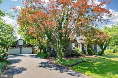
PLEASE NOTE: The primary residence features 4BR and 3BA and showcases all the exceptional amenities outlined in the listing. As an added bonus, a separate apartment—connected to the garage—offers its own kitchen, full bath, living room, loft-style bedroom, private patio, and dedicated entrance—perfect for guests, extended family, a home office, or private studio.
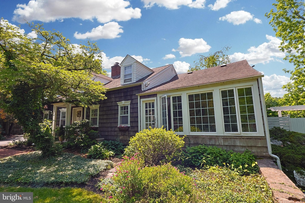
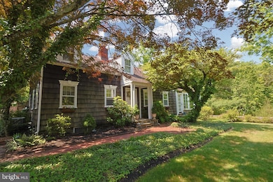
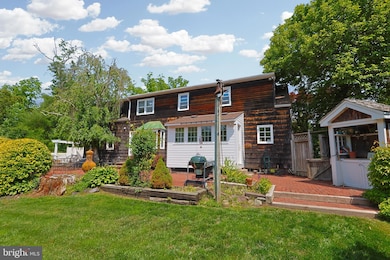
Welcome to this beautifully updated 4-bedroom, 3-bathroom Cape Cod home nestled on the tranquil banks of Mill Creek. Set on a large, private lot, this charming home offers the perfect blend of peaceful living and modern convenience.
Inside, the main living areas feature hardwood floors, abundant natural light, a stone fireplace, and stylish updates throughout... all set within a thoughtful flowing layout. The heart of the home is the modern kitchen, offering quartz countertops, stainless steel appliances, and views of the expansive backyard and creek beyond. The first floor is capped off with a private bedroom and full bathroom providing flexibility for guests or convenient one-level living.
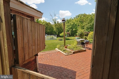
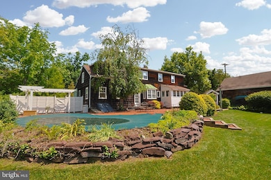
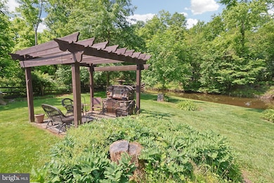
Step outside to your backyard oasis overlooking Mill Creek with lush landscaping, a sparkling in-ground pool, and an expansive patio space that creates a true backyard haven ideal for entertaining, gardening, or simply relaxing by the water.
Tucked away in a quiet, creekside setting, yet close to local amenities, this one-of-a-kind property is a rare find. Schedule your private tour today and discover the lifestyle you’ve been dreaming of!
Last Agent to Sell the Property
(215) 431-8412 matt@buysellsimply.com EXP Realty, LLC License #RS347850 Listed on: 06/25/2025
| Date | Type | Sale Price | Title Company |
|---|---|---|---|
| Deed | $755,000 | National Integrity | |
| Deed | $655,000 | -- | |
| Quit Claim Deed | -- | -- |
| Date | Status | Loan Amount | Loan Type |
|---|---|---|---|
| Open | $679,500 | New Conventional | |
| Previous Owner | $482,000 | Fannie Mae Freddie Mac |
| Date | Event | Price | List to Sale | Price per Sq Ft |
|---|---|---|---|---|
| 09/11/2025 09/11/25 | Sold | $755,000 | +0.8% | $324 / Sq Ft |
| 07/14/2025 07/14/25 | Price Changed | $749,000 | -6.3% | $322 / Sq Ft |
| 06/25/2025 06/25/25 | For Sale | $799,000 | -- | $343 / Sq Ft |
| Year | Tax Paid | Tax Assessment Tax Assessment Total Assessment is a certain percentage of the fair market value that is determined by local assessors to be the total taxable value of land and additions on the property. | Land | Improvement |
|---|---|---|---|---|
| 2025 | $3,973 | $24,400 | $6,880 | $17,520 |
| 2024 | $3,973 | $24,400 | $6,880 | $17,520 |
| 2023 | $3,838 | $24,400 | $6,880 | $17,520 |
| 2022 | $3,792 | $24,400 | $6,880 | $17,520 |
| 2021 | $3,747 | $24,400 | $6,880 | $17,520 |
| 2020 | $3,747 | $24,400 | $6,880 | $17,520 |
| 2019 | $3,722 | $24,400 | $6,880 | $17,520 |
| 2018 | $3,722 | $24,400 | $6,880 | $17,520 |
| 2017 | $3,692 | $24,400 | $6,880 | $17,520 |
| 2016 | $3,728 | $24,400 | $6,880 | $17,520 |
| 2015 | -- | $24,400 | $6,880 | $17,520 |
| 2014 | -- | $24,400 | $6,880 | $17,520 |
Seller's Agent in 2025
Matt Kapusta
EXP Realty, LLC
(215) 431-8412
10 in this area
81 Total Sales
Buyer's Agent in 2025
Kelly Guida-Patrizio
Coldwell Banker Realty
(856) 316-9459
1 in this area
226 Total Sales
Source: Bright MLS
MLS Number: PABU2097486
APN: 06-023-019-001
Disclaimer: Certain information contained herein is derived from information provided by parties other than Homes.com. All information provided is deemed reliable, but is not guaranteed to be accurate and should be independently verified.
![]() The data relating to real estate for sale on this website appears in part through the BRIGHT Internet Data Exchange program, a voluntary cooperative exchange of property listing data between licensed real estate brokerage firms, and is provided by BRIGHT through a licensing agreement.
The data relating to real estate for sale on this website appears in part through the BRIGHT Internet Data Exchange program, a voluntary cooperative exchange of property listing data between licensed real estate brokerage firms, and is provided by BRIGHT through a licensing agreement.
Listing information is from various brokers who participate in the Bright MLS IDX program and not all listings may be visible on the site.
The property information being provided on or through the website is for the personal, non-commercial use of consumers and such information may not be used for any purpose other than to identify prospective properties consumers may be interested in purchasing.
Some properties which appear for sale on the website may no longer be available because they are for instance, under contract, sold or are no longer being offered for sale.
Property information displayed is deemed reliable but is not guaranteed.
Copyright 2025 Bright MLS, Inc.