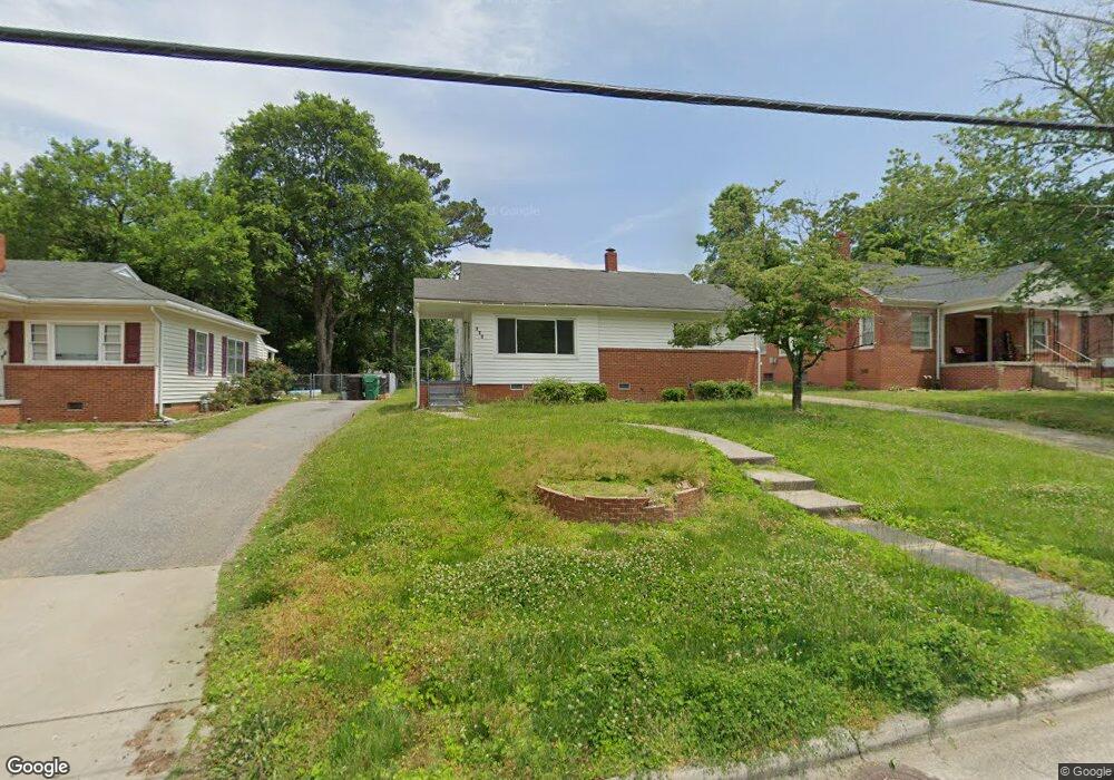
728 Forrest St High Point, NC 27262
Greater High Point NeighborhoodEstimated Value: $131,000 - $163,000
2
Beds
1
Bath
912
Sq Ft
$165/Sq Ft
Est. Value
About This Home
This home is located at 728 Forrest St, High Point, NC 27262 and is currently estimated at $150,667, approximately $165 per square foot. 728 Forrest St is a home located in Guilford County with nearby schools including Kirkman Park Elementary School, Penn-Griffin School for the Arts, and T.W. Andrews High School.
Ownership History
Date
Name
Owned For
Owner Type
Purchase Details
Closed on
Feb 11, 2021
Sold by
Hill Dexter J and Triad Quality Homes Llc
Bought by
Bms Investment Properties Llc
Current Estimated Value
Purchase Details
Closed on
Aug 9, 2011
Sold by
Roberson Jonathon E
Bought by
Triad Quality Homes Llc
Purchase Details
Closed on
Jun 25, 2003
Sold by
Mcconnell Hardison G and Mcconnell Robbie Lynn
Bought by
Roberson Jonathon E
Home Financials for this Owner
Home Financials are based on the most recent Mortgage that was taken out on this home.
Original Mortgage
$59,000
Interest Rate
5.43%
Mortgage Type
Purchase Money Mortgage
Create a Home Valuation Report for This Property
The Home Valuation Report is an in-depth analysis detailing your home's value as well as a comparison with similar homes in the area
Home Values in the Area
Average Home Value in this Area
Purchase History
| Date | Buyer | Sale Price | Title Company |
|---|---|---|---|
| Bms Investment Properties Llc | $127,500 | None Available | |
| Triad Quality Homes Llc | $26,775 | None Available | |
| Roberson Jonathon E | $60,000 | -- |
Source: Public Records
Mortgage History
| Date | Status | Borrower | Loan Amount |
|---|---|---|---|
| Previous Owner | Roberson Jonathon E | $59,000 |
Source: Public Records
Tax History Compared to Growth
Tax History
| Year | Tax Paid | Tax Assessment Tax Assessment Total Assessment is a certain percentage of the fair market value that is determined by local assessors to be the total taxable value of land and additions on the property. | Land | Improvement |
|---|---|---|---|---|
| 2025 | $870 | $63,100 | $14,000 | $49,100 |
| 2024 | $870 | $63,100 | $14,000 | $49,100 |
| 2023 | $870 | $63,100 | $14,000 | $49,100 |
| 2022 | $851 | $63,100 | $14,000 | $49,100 |
| 2021 | $781 | $56,700 | $14,000 | $42,700 |
| 2020 | $781 | $56,700 | $14,000 | $42,700 |
| 2019 | $781 | $56,700 | $0 | $0 |
| 2018 | $777 | $56,700 | $0 | $0 |
| 2017 | $781 | $56,700 | $0 | $0 |
| 2016 | $760 | $54,200 | $0 | $0 |
| 2015 | $764 | $54,200 | $0 | $0 |
| 2014 | $777 | $54,200 | $0 | $0 |
Source: Public Records
Map
Nearby Homes
- 719 Forrest St
- 509 Woodrow Ave
- 313 Woodrow Ave
- 910 E Dayton Ave
- 326 Louise Ave
- 907 E Dayton Ave
- 1108 Forrest St
- 1110 Forrest St
- 506 Denny St
- 410 4th St
- 828 Willow Place
- 837 Willow Place
- 504 Avalon Place
- 905 Mint Ave
- 505 Forrest St
- 1428 Futrelle Dr
- 1013 Johnson St
- 1207 N Main St
- 1507 Larkin St
- 901 Circle Dr
- 726 Forrest St
- 730 Forrest St
- 724 Forrest St
- 600 E Farriss Ave
- 913 Denny St
- 911 Denny St
- 915 Denny St
- 722 Forrest St
- 602 E Farriss Ave
- 917 Denny St
- 909 Denny St
- 727 Forrest St
- 720 Forrest St
- 604 E Farriss Ave
- 606 E Farriss Ave
- 907 Denny St
- 723 Forrest St
- 718 Forrest St
- 546 E Farriss Ave
- 912 Denny St